Localised Adaptive Spatial-Temporal Graph Neural Network
This paper introduces the Localised Adaptive Spatial-Temporal Graph Neural Network model, focusing on the importance of spatial-temporal data modeling in graph structures. The challenges of balancing spatial and temporal dependencies for accurate inference are addressed, along with the use of distri
3 views • 19 slides
Understanding Neo4j Graph Database Fundamentals
This comprehensive presentation delves into the fundamentals of Neo4j graph database, covering topics such as the definition of graph databases, reasons for their usage, insights into Neo4j and Cypher, practical applications like data flow analysis, and hands-on instructions on creating and querying
0 views • 20 slides
Introduction to Spatial Data Mining: Discovering Patterns in Large Datasets
Spatial data mining involves uncovering valuable patterns from extensive spatial datasets, offering insights into historical events, environmental phenomena, and predictive analytics. Examples range from analyzing disease outbreaks to predicting habitat suitability for endangered species. The applic
1 views • 20 slides
Understanding Spatial Database Systems: An Overview
This presentation by Xiaozhi Yu introduces the fundamentals of spatial database systems, covering topics such as spatial data types, relationships, system architecture, modeling, and organizing underlying spaces. It delves into the importance of integrating geometry into DBMS data models, spatial in
1 views • 30 slides
National Database of Cooperatives: Ministry of Cooperation Initiatives
The Ministry of Cooperation is developing a National Database of Cooperatives to enhance transparency, governance, and policymaking in the cooperative sector. The database aims to provide comprehensive information on cooperatives across sectors, improve coordination among stakeholders, and facilitat
0 views • 22 slides
Database Design Principles and Management Overview
This document presents an overview of database design principles, including structured, semi-structured, and unstructured data types. It delves into the role of Database Management Systems (DBMS) in defining, constructing, manipulating, and sharing databases effectively. It also covers various types
0 views • 47 slides
Introduction to Database Management System Explained
This presentation covers the basics of database management systems, including definitions of data, types of data, structured and unstructured data, storing data in computers using file systems and database systems, and issues with file systems like data redundancy, inconsistency, difficult data acce
1 views • 18 slides
Understanding Spatial Analysis in GIS for Effective Decision-Making
Spatial analysis in GIS involves modeling geographic problems, processing data, and exploring results to understand spatial relationships, patterns, and suitability for various purposes. GIS tools offer unique capabilities for handling geographically referenced data, data entry, storage, manipulatio
2 views • 21 slides
Understanding Database Normalization and Functional Dependencies
Database normalization is a crucial process that aims to improve database design by organizing data into higher forms of normality. This helps in reducing redundancy and ensuring data integrity. Functional dependencies play a key role in defining relationships between attributes in a database. By un
0 views • 33 slides
Oracle 19c Standard Edition: RAC Migration and Database Solutions Overview
Explore the implications of Oracle Database 19c Standard Edition no longer supporting RAC, and learn about disaster recovery and high availability options for users. Delve into the differences between HA and DR, along with the significance of workload isolation and scalability in database management
3 views • 22 slides
Understanding Database Management Systems (DBMS)
A Database Management System (DBMS) is a crucial tool for organizing, storing, and managing data efficiently. It allows users to create, update, retrieve, and delete data effectively, ensuring data consistency and security. DBMS software like MySQL and Oracle provide interfaces for various database
0 views • 21 slides
Costs and Risks of Implementing a Database Approach
Implementing a database approach involves additional costs and risks that need to be managed effectively. From hiring specialized personnel to dealing with conversion costs and organizational conflicts, organizations must carefully consider the implications of transitioning to a database system. The
0 views • 10 slides
Understanding Spatial Referencing Systems for Mapping
Spatial reference systems play a crucial role in defining geographic parameters and coordinate systems for mapping. They consist of components like orientation, latitude, longitude, and elevation, which help in representing spatial properties on maps. Reference surfaces such as the Geoid and ellipso
3 views • 13 slides
Database Design Process and Concepts
This lecture on designing databases covers the database design process, normalization, transforming E-R diagrams, physical database design concepts, and steps in logical database modeling. It highlights the importance of logical and physical database design in system development, providing insights
0 views • 64 slides
Understanding Entity-Relationship Model in Database Systems
This article explores the Entity-Relationship (ER) model in database systems, covering topics like database design, ER model components, entities, attributes, key attributes, composite attributes, and multivalued attributes. The ER model provides a high-level data model to define data elements and r
0 views • 25 slides
Understanding Database Systems in IT
Database systems play a crucial role in managing and organizing data efficiently. They provide a structured environment for storing and accessing information, enabling various applications in sectors like banking, airlines, universities, sales, and more. The transition from traditional file systems
3 views • 38 slides
Spatial Analysis & Modeling for Spatial Planning Training in Maputo, Mozambique
Explore spatial analysis techniques for efficient route planning, site selection, pattern identification, and value prediction in the context of spatial planning. Learn about surface modeling, relationships among features, and the importance of spatial modeling in addressing geographical problems.
0 views • 27 slides
Understanding Entity-Relationship Diagrams (ERD) for Database Design
Entity-Relationship Diagrams (ERD) are vital in database design, illustrating entities and their relationships. They help in conceptualizing data models and laying the groundwork for database structures. The process involves identifying entities, defining relationships, and analyzing interactions to
0 views • 40 slides
Performers and Programs Database Webinar - Overview and Features
Learn about the Performers and Programs Database Webinar happening on October 22, 2021. This webinar, presented by Peter Kowalski and introduced by Sharon B. Phillips, offers valuable information about the database's features, including how performers advertise programs, categorization, virtual prog
0 views • 25 slides
GIS Data Models for Spatial Planning Training in Maputo, Mozambique
Explore the concepts of GIS data models including vector vs. raster, spatial relationships, spatial operations, and representation of real-world entities in a spatial database. Understand how spatial data models are used to manipulate spatially-referenced information and define the spatial location
1 views • 32 slides
Introduction to Database Systems and SQL Programming
Understanding database systems is crucial in today's digital world. Explore the basics of database systems, SQL statements, and Java Database Connectivity (JDBC) in this comprehensive overview. Learn about DBMS, SQL querying, JDBC API, and more to enhance your understanding of managing and interacti
8 views • 24 slides
Understanding Spatial Autocorrelation in Geostatistical Analysis
Explore the concept of spatial autocorrelation, its implications in geostatistical analysis, and the importance of detecting and interpreting it correctly. Learn about auto-correlation, signal components, correlation significance, and measuring autocorrelation using tools like Moran's I. Gain insigh
0 views • 12 slides
Overview of Database Systems Architecture and Languages
A database system is essential for storing and managing an organization's data. The architecture includes components like file manager, database manager, and query processor. Additionally, DML and DDL compilers play crucial roles in handling data manipulation and definition tasks. Various data struc
2 views • 28 slides
Enhancing Coastal Spatial Systems and Database Management for R2R Investments
This presentation delves into the enhancement and training of national GIS/Data Practitioners on R2R coastal spatial systems, governance, and socioeconomic baseline assessments. It explores the use of EGS and DPSIR approaches, along with the integration of existing databases for future R2R investmen
0 views • 4 slides
Spatial Relation Switching Requirements in 3GPP NR RAN Plenary Meeting
The document discusses various spatial relation switching requirements for uplink scenarios in the 3GPP NR RAN Plenary Meeting. It covers agreement points related to UL SRS, PUCCH, P-SRS, and DL-RS, defining delay requirements and known conditions for spatial relation switching. The agreements provi
0 views • 11 slides
Contrasting Operational Database Systems and Data Warehouses: Key Variances Explained
Understanding the disparities between operational database systems (OLTP) and data warehouses (OLAP) is crucial. OLTP systems focus on transaction processing for daily operations, while OLAP systems cater to data analysis and decision-making needs. Variances include user orientation, data content, d
0 views • 12 slides
Understanding Database Management Systems and Concepts
Explore the world of databases with topics ranging from Database Creation and Management to Basic Database Terms. Learn about the significance of data, information, and metadata in decision-making processes. Discover the purpose of database systems and the role of Database Management Systems (DBMS)
0 views • 25 slides
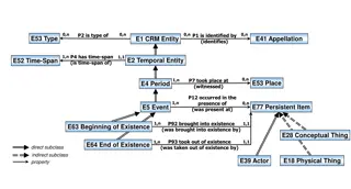
Understanding Temporal and Spatial Information Models
This content delves into the intricacies of temporal and spatial information models, covering concepts such as existence, presence, and spatiotemporal relationships. It explores how entities are identified, events are witnessed, and durations are defined within these models. The interplay between ti
3 views • 9 slides
Database Implementation Issues in Programming Studio
Key topics covered in the slides include database implementation issues, storing data efficiently, and strategies for handling variable length fields in tuple storage. The presentation delves into specialized algorithms for database efficiency and reliability, terminology related to database impleme
0 views • 32 slides
Understanding Spatial Extremes: Complex Time Methods in Hydro-Atmospheric Dynamics
This study explores the use of complex time methods and chameleon scalar fields in understanding and modeling spatial extremes in hydrological and atmospheric systems. By transforming Lagrangian processes and introducing chameleon scalar fields, the research unveils new insights into the mechanism g
0 views • 9 slides
Coordinated Spatial Nulling (C-SN) Simulations in IEEE 802.11-24/0012r0
The document discusses the concept of Coordinated Spatial Nulling (C-SN) in IEEE 802.11-24/0012r0, focusing on spatial nulling feedback, synchronization needs, advantages of partial nulling, and comparison of half-coordinated versus fully coordinated scenarios. Simulation results are presented, anal
0 views • 19 slides
The World of Azure Database Offerings
Exploring Azure's database offerings including Azure Cosmos DB and Azure SQL Database. Azure Cosmos DB provides a globally scalable document database solution, while Azure SQL Database is a great option for SQL Server workloads. Both platforms offer unique features such as low latency, scalability,
0 views • 15 slides
Enhancing Spatial Data Analysis in QGIS
Explore the integration of relational databases with QGIS to facilitate efficient spatial data analysis. Discover the importance of recognizing spatial relationships within data sets and the solutions to enhance QGIS for relational datasets. Overcome challenges and delve into the intersection and su
0 views • 25 slides
Overview of Databases and Recent Developments in Database Systems
Explore the fundamentals of databases, including types, applications, users, and advantages. Learn about traditional and recent database applications, such as social networks, search engines, and emerging technologies like Big Data systems and NOSQL. Understand the concept of databases as a collecti
0 views • 30 slides
Understanding Database Management Systems (DBMS): A Comprehensive Overview
This comprehensive overview of Database Management Systems (DBMS) covers the definition, environment, advantages, limitations, and characteristics of data in a database. It delves into the hardware and software components, user roles, and benefits of using a DBMS. The content highlights the control
0 views • 25 slides
Analysis of MIMO for IMMW Transmission in IEEE 802.11-24
Proposal discusses the suitability of MIMO for IMMW transmission under different scenarios. The analysis focuses on the number of spatial streams based on channel rank and quality, recommending dual-polarization for LOS paths supporting 2 spatial streams and spatial separation for larger devices sup
0 views • 16 slides
Spatial Multi-Attribute Decision Analysis with Incomplete Preference Information
In this study by Mikko Harju, Juuso Liesi, and Kai Virtanen from Aalto University, the focus is on spatial decision analysis for scenarios where decision alternatives have varying consequences across a geographical region. The research delves into the significance of spatial value functions in repre
0 views • 19 slides
ICAR KRISHI Geo-Portal: Spatial Agricultural Research Information
ICAR KRISHI Geo-Portal is a digital platform aiming to facilitate spatial agricultural data generation, compilation, visualization, and analysis. It hosts spatial databases, provides map services, and allows data sharing across platforms. The portal, developed using open-source technologies, offers
1 views • 32 slides
Understanding Relational Database Design Fundamentals
This content delves into the crucial aspects of relational database design, including normalization, pitfalls, RDBMS design issues, and the overall database design process. It emphasizes the need for well-structured relation schemas to minimize redundancy, ensure data integrity, and facilitate effic
1 views • 53 slides
Understanding Database Normalization and BCNF in Database Systems
Learn about the process of database development, including E-R diagrams, converting to relations, developing database operations, normalization, and BCNF. Explore algorithms for achieving BCNF and example scenarios to understand key concepts in database systems.
0 views • 43 slides
