Guidelines and Recommendations for Hydrographic Offices CATZOC Allocation
The report highlights guidelines for Hydrographic Offices to allocate CATZOC values based on minimum bathymetry standards, ZOC categories, and best practices from various national methodologies. It covers position accuracy, depth accuracy, and seafloor coverage criteria. The allocation is primarily
6 views • 18 slides

Coastal Monitoring and Lessons Learned in Southwest England
Southwest England's coastal monitoring efforts, including the South West Coastal Monitoring program and lessons learned from the destruction of Hallsands in 1917 due to lack of understanding of coastal processes. The monitoring involves data collection on beach profiles, bathymetry, wave patterns, a
4 views • 15 slides

Multibeam Data Analysis for Seabed Characterization at Deception Island, Antarctic
This work explores the morphological and sedimentary characterization of the seabed at Deception Island, Antarctic, through the analysis of multibeam bathymetric data and geological samples. The study identifies ravines, depressions, and volcanic structures as key features, revealing a seabed predom
0 views • 7 slides
IRCC10 Meeting Outcomes and Initiatives
IRCC10, held in Goa, India, reviewed reports from subordinate bodies, emphasized regional coordination, and agreed on revisions to IHO Resolution 2/1997. The meeting also highlighted achievements in Capacity Building and addressed issues related to Crowd-Sourced Bathymetry and the Worldwide ENC Data
0 views • 11 slides
Collaboration Team for Seabed 2030 in Denpasar, Bali - Proposal for Enhanced Coordination
Proposal for establishing a Seabed 2030/CSB Coordinator Collaboration Team to enhance communication between RHC Coordinators. The team aims to discuss progress, challenges, and successes semiannually, fostering support for the Seabed 2030 Project and Crowdsourced Bathymetry Initiative. Key recommend
0 views • 7 slides
Romanian-Norwegian Strategic Cooperation in Maritime Higher Education - MARINTECH Project
Romanian-Norwegian strategic cooperation in maritime higher education through the MARINTECH Project aims to enhance human capital and knowledge base in marine intelligent technologies. The project includes intensive programs like the Bathymetry and Oceanography Summer School to develop innovative le
0 views • 8 slides
Tsunamis in the POLA and POLB: Wave Interactions and Considerations
Tsunamis' impact on harbors like POLA and POLB, including wave interactions with moored ships and land-side facilities. Explore the response of harbors to wave-induced oscillations, velocity considerations, and tsunami sources. Insights into historic far-field tsunamis and Southern California bathym
0 views • 13 slides

High-Resolution 3D Seafloor Topography Enhancement Using Kalman Filtering
Proposing a Kalman Filter approach to refine seafloor topography estimation by integrating various geophysical data types. The method allows for producing regional bathymetry with higher resolution, truncating unnecessary observations, and reducing the matrix dimensions in the inverse problem. Inclu
0 views • 9 slides

Bathymetry Trackline Fitting Techniques at ACM SIGSPATIAL GIS 2009
Tsz-Yam Lau, You Li, Zhongyi Xie, and W. Randolph Franklin presented various ship trackline fitting techniques at the ACM SIGSPATIAL GIS 2009 conference in Seattle. The study explored methods such as Inverse Distance Weighting, Kriging, Voronoi, Linear Spline, Quadratic Spline, and more for bathymet
0 views • 12 slides
Overview of Nordic Hydrographic Commission Activities
The Nordic Hydrographic Commission (NHC) has been actively involved in various initiatives and projects related to hydrography and maritime safety. Their recent meetings have focused on topics such as digital products for the leisure market, S-100 product developments, and new ship route systems in
0 views • 12 slides
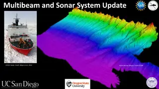
Update on Multibeam and Sonar Systems for USCGC Healy
The update for USCGC Healy includes recommendations for multibeam and sonar systems, such as utilizing either Kongsberg EM124 or EM304 with additions like shallow water mapping and EK80 Fisheries Sonar capability. Two high-resolution multibeam options are detailed: Option 1 pairs Kongsberg EM712 wit
0 views • 16 slides
South West Pacific Hydrographic Commission Country Report for Kiribati
Kiribati's country report highlights achievements such as receiving satellite-derived bathymetry datasets, hosting awareness workshops, and pursuing funding for LIDAR surveys. Challenges include limitations in meeting mapping authority standards and a lack of legislative support for hydrographic act
0 views • 13 slides
IHO ENC Maintenance Working Group Report 2019
Report from the International Hydrographic Organization's ENC Maintenance Working Group meeting in Monaco, covering tasks, membership, S-4 updates, clarifications, and discussions on encoding floodlighting colors in S-57 charts. Topics include submarine cables and bathymetry.
0 views • 13 slides
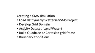
Creating a CMS Simulation: Grid Domain Activity Dataset Development
Developing a CMS simulation involves loading bathymetry data, setting boundary conditions, creating grid domains (land/water), and choosing between Quadtree or Cartesian grid structures. Learn how to manage survey datasets, add new coverages, define grid frames, and set up the land/water interface f
0 views • 14 slides

Draft Initial Communications Plan for IHO CSB WG 14/xx
This draft communication plan outlines the objectives, goals, infrastructure, target audience, messages, spokespersons, channels, budget, deliverables, schedule, success metrics, and elements for effectively managing communications related to the Crowdsourced Bathymetry project and its stakeholders.
0 views • 17 slides
Highlights from 15th Conference of EAtHC, Lagos, Nigeria, 17-19 October 2018
Items discussed at the 2nd meeting of the IHO Council during the 15th Eastern Atlantic Hydrographic Commission Conference included ensuring use of the IHO Fund for Special Projects, coordination between RHCs, approval of IHO publication B-12 on Crowdsourced Bathymetry, elimination of overlapping ENC
0 views • 7 slides
Understanding Benthic Substrate Characterization Through Multibeam Bathymetry
Utilizing multibeam bathymetry and backscatter data, this project focuses on mapping potential benthic substrates in marine environments. The history, procedures, and possible classification schemes are discussed, highlighting the importance of analyzing backscatter data for sediment classification.
0 views • 28 slides
International Reports and Proposals on Capacity Building and Maritime Safety
Explore reports on capacity building sub-committee's resource needs, investigating electronic navigation services, challenges in maritime safety information infrastructure in Africa, progress on GEBCO Project Seabed 2030, crowdsourced bathymetry initiatives, and advancements in marine spatial data i
0 views • 14 slides