Progress Update and Activities of PGSC Working Group
The PGSC Working Group has been actively supporting the implementation of Goal 2 of the PGSC Strategy by advancing a modern Geodetic Reference Frame in the Pacific region. Key activities include capacity mapping, legal framework reviews, strategic planning, and stakeholder engagement efforts. The gr
1 views • 10 slides
Geodetic Surveying and Triangulation System Overview
Geodetic surveying involves determining precise positions on the Earth's surface, while triangulation is a method that uses interconnected triangles for accurate measurements. The principles of the triangulation system aim to establish horizontal points for various surveys and assist in determining
2 views • 23 slides
Spatial Referencing Systems for Mapping
Spatial reference systems play a crucial role in defining geographic parameters and coordinate systems for mapping. They consist of components like orientation, latitude, longitude, and elevation, which help in representing spatial properties on maps. Reference surfaces such as the Geoid and ellipso
5 views • 13 slides
Cadastral Mapping Components and Data Sources
Cadastral mapping involves geodetic control networks, parcel identification, and various overlays like zoning and floodplains. City maps are categorized into base, derived, and thematic maps. Data sources include spatial and non-spatial data for property assessment. Layers in cadastral maps cover to
1 views • 16 slides
Geospatial Summit Feedback and Transition Needs for US Army Corps of Engineers
Feedback and preparation for the new datums discussed at the 2015 Geospatial Summit by US Army Corps of Engineers, highlighting advantages, challenges, and transition tools and outreach needs for the organization. Emphasis is placed on the importance of vertical datums consistency, relationship impr
1 views • 4 slides
Tropospheric Delays in Geodetic Techniques
Explore the fundamentals of troposphere delays in geodetic measurements, including refractivity, modeling techniques, and impact on positioning accuracy. Discover the complexities of radio signal delays and bending effects due to atmospheric interactions. Gain insights into the Vienna troposphere mo
0 views • 80 slides
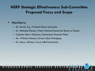
Strategies for Enhancing PORTS System Effectiveness and Resilience
Proposed by the HSRP Strategic Effectiveness Sub-Committee, this focuses on improving the PORTS system, addressing water level changes, enhancing NOAA's products and services, and strengthening outreach and branding. Key issues identified include inconsistent funding for PORTS systems, inadequate co
0 views • 10 slides
National Geodetic Survey Modernization Overview
The National Geodetic Survey (NGS) is modernizing the National Spatial Reference System (NSRS) to enhance accuracy, accessibility, and efficiency. This involves updating coordinates, replacing datums, simplifying services, and ensuring compatibility with time changes. The goal is to provide a reliab
0 views • 31 slides

Geodetic Datums - A Comprehensive Overview
Delve into the world of geodetic datums with a detailed exploration of concepts, historical developments, and future perspectives. Learn about NAD 83, WGS 84, terminology shifts, and the significance of geodetic datums in modern mapping and Earth measurements.
0 views • 22 slides
Geodetic Datums and WGS-84 Coordinates
Geodetic datums define the earth's shape and size, serving as reference points on coordinate systems. Vertical datums establish zero surface elevation, while horizontal datums form the basis for horizontal coordinates. The World Geodetic System 1984 (WGS-84) is the reference system used by GPS and l
0 views • 29 slides
Coordinate Systems, Map Projections, and GIS Applications
Explore the intricacies of Geographic Coordinate Systems, Projected Coordinate Systems, and different types of map projections as part of the Remote Sensing and GIS Application course taught by Lecturer Ruba Yousif Hussain in the third year. Dive into the properties of map projections like conforman
0 views • 13 slides
Advancements in Geodetic Reference Systems and CORS Networks at XXV FIG Congress
Explore the latest updates from the XXV FIG Congress regarding the role of National Mapping Organisations in providing Positioning Infrastructure and ensuring Precision Navigation and Timing Integrity. Key highlights include NAD 83 replacement, CORS enhancements, alignment strategies, transformation
0 views • 17 slides
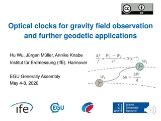
Optical Clocks for Gravity Field Observation and Geodetic Applications
Optical clocks play a crucial role in observing gravity fields and have various geodetic applications. From comparing space-to-ground and space-to-space clocks to detecting mass loss in Greenland, these clocks offer high-frequency sampling data for precise measurements. They also aid in unifying hei
0 views • 10 slides
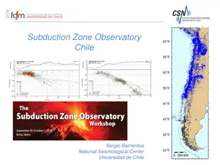
Monitoring Chile's Geological and Volcanic Activity: Subduction Zone Observatory and IPOC Network
Chile's Subduction Zone Observatory, led by Sergio Barrientos at the National Seismological Center, University of Chile, focuses on observing seismic and geological events with cutting-edge technology and networks. The IPOC Chile Volcanological Network monitors around 40 volcanoes, utilizing various
0 views • 4 slides
Geodetic Survey and Reference Frames in Canada
The Canadian Geodetic Survey plays a crucial role in the publication of coordinates, utilizing frames like NAD83(CSRS) and CGVD2013. The adoption of geoid-based vertical datums reflects advancements in technology and the need to maintain accurate reference systems. The transition from older referenc
0 views • 15 slides
HYPACK 2022 Training Event: Water Quality Data Processing Overview
In the HYPACK 2022 Training Event, participants will learn about processing water quality sensor data, ADCP in-situ data, and geodetic parameters. The session covers tools included in HYPACK, changes to streamline workflows, and the Environmental Editor program for loading and processing data. Atten
0 views • 12 slides