
Impact of North America's Physical Characteristics on Settlement Patterns
Physical characteristics such as landforms, bodies of water, climate, and natural resources in North America play a significant role in shaping settlement patterns. Major features like the Mississippi River System, Appalachian Mountains, Rocky Mountains, and Canadian Shield have influenced how and w
5 views • 13 slides

Understanding Alluvial Fans: Formation, Characteristics, and Morphology
Alluvial fans are cone-shaped landforms formed by streams carrying sediments from mountains onto plains. They are prominent in arid to semi-arid regions and vary in size from a few meters to over 150 kilometers. The different zones of an alluvial fan, including the fan apex and distal fan, display d
5 views • 9 slides
Southwest Asia: Landforms and Resources
Southwest Asia, particularly the Arabian Peninsula, is rich in diverse landforms and resources. The region is characterized by major mountain ranges like the Hindu Kush and Zagros Mountains, important bodies of water such as the Tigris and Euphrates Rivers, and natural features like wadis and the Jo
0 views • 12 slides
A River from Source to Sea
Explore the transformation of rivers and surrounding landscapes from the source to the sea. Discover how natural and man-made processes shape river channels, create diverse landforms, and influence the flow dynamics. Follow the evolution of a river from its hilly beginnings to the wide expanses at i
0 views • 22 slides
Understanding the Pace of Landform Changes
Exploring how landforms transform over time, this lesson delves into the speed at which geological features evolve. By comparing examples like the Grand Canyon and the Mississippi River delta, students learn how scientists collect data to determine the rate of change through measurements and photogr
5 views • 18 slides
Glacial Landforms: Rock Steps, Truncated Spurs, Hanging Valleys, and Crag & Tail
Explore the formation of unique glacial landforms such as rock steps, truncated spurs, hanging valleys, and crag & tail. Discover how glaciers sculpt these distinct features through processes like erosion and deposition, leaving behind stunning geological formations exemplified in locations like Ble
7 views • 43 slides

Aeolian Landforms: Shaping Earth's Surface Through Wind Action
Geomorphic processes, including aeolian processes, play a significant role in modifying the earth's surface. This article delves into how wind erosion and deposition create unique landforms such as ventifacts and yardangs. Understanding the transportation methods and topographic effects of wind eros
0 views • 22 slides
Understanding Volcanic Eruptions: Key Terminology and Processes
Volcanic eruptions are caused by the release of pressure inside the Earth, leading to the expulsion of magma through volcanic vents. This process results in the formation of cone-shaped mountains or hills known as volcanoes. The magma, which originates from the asthenosphere, rises through cracks in
1 views • 24 slides
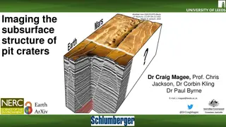
Exploring Subsurface Structures of Pit Craters Through Seismic Reflection
Discover the technique of seismic reflection imaging to unveil the subsurface structures of pit craters on Earth and Mars. Follow the analysis of seismic data to map pit craters and their connections to geological features like dykes and fault jogs, shedding light on the formation processes of these
0 views • 11 slides
Understanding Penck's Cycle of Erosion in Geomorphology
Walther Penck introduced an alternative model to Davisian cycle, emphasizing the interplay between upliftment and erosion rates in landscape formation. Penck's concept focuses on relative intensity of degradation processes, phase of upliftment, and rates of erosion, rejecting the idea of stages in l
2 views • 32 slides
Understanding Slope Development Theories by Walther Penck in Geomorphology
Explore the Slope Development Theories by Walther Penck in Geomorphology, focusing on concepts like Pendiplanation, Pedimentation, and the relation between endogenic and exogenic forces in shaping landscapes. Learn about the evolution of landforms and the criticism of the Davisian theory of Erosion
1 views • 28 slides
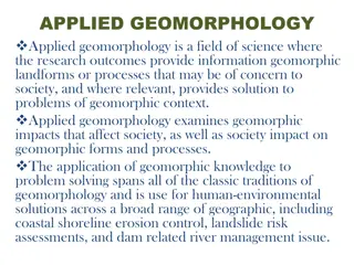
Understanding Applied Geomorphology and Its Importance in Society
Applied Geomorphology is a vital field of science focusing on how geomorphic landforms and processes impact society and vice versa. It provides solutions to problems such as coastal erosion, landslides, and river management. By applying geomorphic knowledge, scientists, engineers, and decision-maker
1 views • 7 slides
Understanding Regions in Geography
Regions in geography are defined by common features such as climate, landscape, language, or religion. They serve as basic units of geography, with the Middle East being a notable example encompassing political, environmental, and religious characteristics. Regions can be classified based on physica
0 views • 10 slides
Understanding Geography: Earth's Description and Study
Geography, coined by Greek scholar Eratosthenes, encompasses the description and explanation of Earth's surface differentiation. It involves physical and human aspects, with branches like geomorphology, climatology, and economic geography. Physical geography studies the lithosphere, atmosphere, hydr
0 views • 6 slides
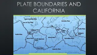
Plate Boundaries and Geological Events in California
California is located on a plate boundary experiencing major geologic events. The state's landforms are shaped by plate tectonic activity. Understanding stress types at plate boundaries can help prevent damage and save lives. The interaction at plate boundaries plays a crucial role in shaping Earth'
0 views • 14 slides
Aeolian Landforms and Processes: A Geographical Study by Ms. Annu
Geomorphic processes are crucial in shaping the Earth's surface, with Aeolian processes driven by wind erosion, transportation, and deposition. This study explores the topographic effects of wind erosion, transportation methods, and the formation of Aeolian landforms like ventifacts and yardangs. Th
0 views • 22 slides
Understanding Earth's Landforms: Erosion, Deposition, and Weathering
Explore the processes of erosion, deposition, and weathering that shape Earth's landforms over time. From the breakdown of rock through weathering to the movement of eroded material by erosion and the settling of sediments by deposition, witness the continuous transformation of Earth's surface. Disc
1 views • 14 slides

Exploring Kamloops: Landforms, Climate, Vegetation, and Environmental Issues
Discover the diverse landscape of Kamloops with its mountains, lakes, and unique vegetation. Learn about the hot summers and cold winters, ideal for activities like golfing and snowshoeing. However, forest fires pose a significant environmental issue, impacting animals, humans, and habitats. Explore
0 views • 9 slides
Exploring Earth's Changing Surface - Lesson 1A
Delve into the surface of Earth with Lesson 1A, questioning its appearance, changes, and characteristics. Learn about surfaces, landforms, and the natural features that shape our world through engaging visual aids and thought-provoking central questions.
0 views • 16 slides

Geological Structures and Landscapes: A Detailed Overview
The illustrations and descriptions in the content depict various geological structures, including faults, folds, anticlines, and their effects on the landscape. The formation processes, such as folding, faulting, weathering, and erosion, are explained, highlighting how these natural phenomena shape
0 views • 9 slides
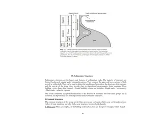
Sedimentary Structures: Types and Significance
Sedimentary structures are features found in sedimentary rocks that provide valuable information about the conditions of deposition, current directions, and depositional environments. They can be erosional, depositional, post-depositional, or biogenic in nature, with examples including flute casts,
0 views • 6 slides

Exploring Australia's Unique Physical Environments in Year 9 Geography
Dive into Year 9 Geography with a focus on Australia's physical landscapes and how people adapt to the challenges they present. Discover the continent's origins, major landforms, natural resources, and vegetation patterns. Uncover the perspectives on Australia's formation and explore the diverse ada
0 views • 35 slides
Understanding Coastal Landforms: Formation and Characteristics
Coastal landforms are features shaped by erosion and sedimentation processes along coastlines. These landforms, including headlands, cliffs, bays, spits, salt marshes, and beaches, are predominantly influenced by factors such as wave action, longshore currents, tides, and climatic elements like wind
0 views • 35 slides
Explore the Mountains and Basins Region of Texas
Discover the unique Mountains and Basins Region of Texas, located in the far west with the Rio Grande as its southern border and New Mexico to the north. This region features diverse landforms including mountains, plateaus, basins, deserts, and rivers like the Pecos and Rio Grande. Important cities
0 views • 19 slides

Understanding National Patriotic Holidays in Kindergarten Social Studies
In Kindergarten Social Studies, children learn about national patriotic holidays such as Presidents' Day, Veterans Day, and Independence Day. They explore the reasons behind these holidays, customs associated with them like parades and fireworks on Independence Day, contributions of historical figur
0 views • 30 slides

Geography Skills Practice for Year 9 Students
Engage in interactive geography skill-building exercises for Year 9 students. Analyze topographic maps, design town layouts, and learn to read scales on graphs. Enhance your knowledge of landforms, vegetation types, distance calculations, and urban planning concepts.
0 views • 31 slides
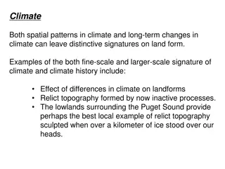
Distinctive Signatures of Climate on Land Form
Climate can leave unique imprints on land forms, both at fine and large scales. Examples include relict topography shaped by past climates and the influence of climate zonation on the Andes' shape. Erosional processes and glacial activities also play significant roles in shaping Earth's surface feat
0 views • 40 slides
Overview of Central America: Landforms, Climates, People, and Cultures
Central America, an isthmus connecting North and South America, comprises seven countries with diverse landforms and climates. The region features mountainous cores, Caribbean lowlands, and Pacific coastal plains, each with unique characteristics. The population is a mix of indigenous peoples, Europ
0 views • 10 slides
Exploring Rivers: Forming Landscapes and Oxbow Lakes
Delve into the fascinating world of rivers and their impact on landscapes. Learn about the creation of landforms by rivers, such as meanders and oxbow lakes. Understand how oxbow lakes form through a series of erosional processes and changes over time. Explore captivating images capturing the beauty
0 views • 9 slides
Forces Shaping Landforms: Inside and Outside the Earth
Explore how landforms change due to forces inside the Earth, like plate boundary activity forming fold mountains, and forces outside the Earth, such as the creation of oceanic trenches. Discover the formation of fold mountains like the Alps and Rockies, as well as deep oceanic trenches like the Mari
0 views • 10 slides

Understanding Earth's Landforms and Features
A detailed overview of Earth's landforms and features, including mountains, hills, plateaus, plains, peninsulas, archipelagos, and continents. Explore the characteristics and classifications of these natural phenomena through informative images and descriptions.
0 views • 21 slides
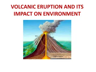
Understanding the Impact of Volcanic Eruptions on the Environment
Explore the causes of volcanic eruptions, including pressure changes, radioactive minerals, plate tectonics, hot spots, earth movement, thermal contraction, and water's role. Learn about different types of volcanicity and the landforms created by both extrusive and intrusive volcanic activity, from
0 views • 20 slides
Understanding Landforms and Topography: An Illustrated Guide
Explore the world of landforms and topography with detailed descriptions and images. Learn about key concepts such as relief, plains, mountain ranges, and plateaus. Understand how elevation, relief, and landforms shape the landscape around us.
0 views • 10 slides

Understanding Landform Changes Over Time
Explore the speed at which landforms change and how scientists gather data to track these transformations. Learn about examples like the Grand Canyon and the Mississippi River delta, and understand the role of flowing water in shaping landforms. Engage in activities to analyze the pace of change in
0 views • 13 slides

Exploring Europe's Diverse Physical Features and Landforms
Discover the intriguing physical features and landforms of Europe, from fjords to polders, dikes, and navigable waterways. Learn about major islands, peninsulas, and distinctive regions like the Northwest Highlands and Alpine mountain system. Explore the water surrounding Europe, including the Medit
0 views • 7 slides
Understanding Aeolian Processes and Erosional Landforms
Aeolian processes, driven by wind, shape landscapes through erosion and deposition. This presentation by Pranati Manna explores wind erosion methods like deflation, corrasion, and attrition, as well as transportation and deposition mechanisms. Aeolian landforms, including deflation basins, mushroom
0 views • 19 slides
Exploring Earth's Changing Surface: Landforms and Geography
Delve into the diverse landscape of Earth as we investigate how the surface varies in different regions. From identifying different landforms to understanding the reasons behind Earth's changing surface, embark on a journey to uncover the mysteries of our planet's geography.
0 views • 14 slides
Exploring India's Drainage System: A Detailed Study
Delve into the intricate drainage system of India with Guest Lecturer S. Maheswari. Learn about the Eastward and Westward flowing rivers, including major ones like Mahanathi, Brahmani, Narmadha, and Tapti. Discover the distinct characteristics of Himalayan and Peninsular rivers, comparing their orig
0 views • 13 slides
Understanding Aeolian Processes and Landforms
Aeolian processes are crucial in arid and semi-arid regions, involving erosion, transportation, and deposition by wind. Factors like wind velocity, grain size, rock composition, and vegetation influence erosion. Different types of wind erosion include deflation, abrasion, and attrition. The transpor
0 views • 18 slides
Understanding Earth's Changing Crust: Landforms, Rocks, and Minerals
The Earth's crust is in constant motion due to plate tectonics, which results in various landforms, rocks, and minerals. This movement is driven by forces such as tension, compression, and shear, causing earthquakes, mountains, and volcanic activity. Through processes like weathering and erosion, th
0 views • 26 slides