Bedrock Geology of Western New Hampshire: Northey Hill Line and Geological Features
The Northey Hill Line in Western New Hampshire is a sinistral shear zone resulting from Late Paleozoic tectonic activities. The area showcases a complex geological history with Acadian thrust nappes, Oliverian domes, and Mesozoic faults, providing insights into the region's structural evolution. This summary highlights the significant geological features and research contributions related to the Northey Hill Line.

Download Presentation

Please find below an Image/Link to download the presentation.
The content on the website is provided AS IS for your information and personal use only. It may not be sold, licensed, or shared on other websites without obtaining consent from the author. Download presentation by click this link. If you encounter any issues during the download, it is possible that the publisher has removed the file from their server.
E N D
Presentation Transcript
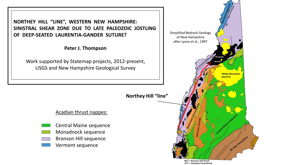
NORTHEY HILL LINE, WESTERN NEW HAMPSHIRE: SINISTRAL SHEAR ZONE DUE TO LATE PALEOZOIC JOSTLING OF DEEP-SEATED LAURENTIA-GANDER SUTURE? Simplified Bedrock Geology of New Hampshire after Lyons et al., 1997 Peter J. Thompson Work supported by Statemap projects, 2012-present, USGS and New Hampshire Geological Survey Northey Hill line Acadian thrust nappes: Central Maine sequence Monadnock sequence Bronson Hill sequence Vermont sequence
Context for the Northey Hill line: 1. Acadian thrust nappes set up conditions for inverted metamorphic isograds. Central Maine sequence and Kinsman granite Monadnock sequence and Bethlehem gneiss Bronson Hill sequence and Oliverian domes Vermont sequence Chesham Pond thrust Brennan Hill thrust/Fall Mtn. nappe Monroe thrust
2. Oliverian domes rose in the latest Acadian, deforming the overlying thrust nappes and isograds. Central Maine sequence and Kinsman granite Monadnock sequence and Bethlehem gneiss Bronson Hill sequence and Oliverian domes Vermont sequence Chesham Pond thrust Brennan Hill thrust/Fall Mtn. nappe Monroe thrust
3. Mesozoic normal faults further disrupted the map pattern. Ammonoosuc fault Grantham fault
What about the Northey Hill line? Younger than the domes, older than the Mesozoic faults. First proposed in Moosilauke 15 Quad (Billings, 1937) Quads (Hadley, 1938 and Chapman, 1939) Followed south through Mt. Cube and Mascoma 15 Shown continuing SW on the state map (Billings, 1955)
What about the Northey Hill line? Younger than the domes, older than the Mesozoic faults. First proposed in Moosilauke 15 Quad (Billings, 1937) Quads (Hadley, 1938 and Chapman, 1939) Followed south through Mt. Cube and Mascoma 15 Shown continuing SW on the state map (Billings, 1955) Lyons et al. (1997) Shown only at Northey Hill on the state map by
Littleton Monroe Northey Hill Woodsville Lyons et al., 1997
Northey Hill Billings, 1935
Billings XC Billings, 1935
Dl Dbg Oam Oam Dl Sc Oo Sf Billings, 1935
Staurolite schist Littleton Formation Northey Hill, NH (coin diameter 25mm)
Dkqm Dl sillimanite Dbg (+/- Fall Mountain thrust nappe) Dl staurolite staurolite Dbg Oam Oam Sc Dl Oo Sf
East-verging D1 folds (Baker, 1954). West-verging D1 folds (this lecture).
Woodsville Sunday Mountain cleavage belt (Rumble, 1969) Piermont allochthon 3 miles Sunday Mountain Lyons et al., 1997
Piermont allochthon Orfordville Sunday Mountain 3 miles Lyons et al., 1997
Orfordville After Orange, 1985 After Orange, 1985 After Orange, 1985
Northey Hill line Orfordville, NH (after Orange, 1985)
Garnet Orange, 1985
Cornish nappe BHA Orange, 1985
Fall Mountain thrust nappe Piermont allochthon Cornish nappe BHA
Post Pond Smarts Mtn Hardy Hill
Post Pond Smarts Mtn
67 48
Post Pond Smarts Mtn NW Sc SE Dl Sc Dl NW SE
What age? Is it a continuation of the Westminster West fault system? ~300 Ma (McWilliams et al., 2014) Ratcliffe et al., 2011
Western limit of Gondwanan detrital zircons (Ryan-Davis et al., 2013) N VT NH 10 Km
Laurentian basement Gander Avalon Poster by Jonathon Wells www.earthexposure.net
Red Indian Line ? Laurentia Gander Avalon


.")