Enhanced Flood and Tax Map Tools in West Virginia

Explore the upgraded WV Flood Tool, offering 3D flood visualizations, building-specific risk assessments, and improved data layers. Additionally, access individual finished tax maps with detailed parcel information and contextual data for 30 counties statewide. The tools provide dynamic web maps, aerial photos, and various formats for viewing and downloading essential information for property assessment and flood risk analysis.

Download Presentation

Please find below an Image/Link to download the presentation.
The content on the website is provided AS IS for your information and personal use only. It may not be sold, licensed, or shared on other websites without obtaining consent from the author. Download presentation by click this link. If you encounter any issues during the download, it is possible that the publisher has removed the file from their server.
E N D
Presentation Transcript
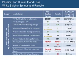
WV Flood Tool Upgrades www.mapWV.gov/Flood Flood Query Results Panel External Links Shared Links Building-Specific Risk Assessments 3D Flood Visualizations Improved Data Layers o Flood Layers o Advisory Floodplains o Mitigated/Buyout Properties o Local Data (parcels, addresses, imagery, elevation) Parcel Search Other Enhancements Future Enhancements 24 April 2017
Tax Map Products Individual Finished Tax Maps Web Digital Parcel File (subset of Digital Tax Map) Finished Tax Maps Map Content Parcel Boundary Parcel Identifier Parcel Dimensions Lot Boundaries Contextual Information Parcel Boundary Parcel Identifier Parcel Dimensions (most viewers) Lot Boundaries (most viewers) Parcel Boundary Parcel Identifier Coverage Statewide* 30 Counties with Web Viewers 95% State Coverage** Current Yes Yes Varies by County Source County Assessors County Assessors Assessors, E-911, MLMP Map System Digital/Manual (80%/20%) Digital (GIS) Digital (GIS) Static or Dynamic Static - viewed as paper map or fixed image Dynamic - interactive web maps with online tools Dynamic - interactive web maps with online tools Linkable to IAS No Yes Yes Seamless No Yes Yes Aerial Photos No Yes Yes Formats Paper or Digital (PDF, JPEG) Print-Ready images Web Map Services Shapefiles, Geodatabase, CAD Files, Web Map Services * All paper tax maps are scanned to a digital image-file format by the Tax Department for statewide coverage ** Varying source years when created
Tax Map Products Individual Finished Tax Maps Web Digital Parcel File (subset of Digital Tax Map) Finished Tax Maps Map Content Parcel Boundary Parcel Identifier Parcel Dimensions Lot Boundaries Contextual Information Parcel Boundary Parcel Identifier Parcel Dimensions (most viewers) Lot Boundaries (most viewers) Parcel Boundary Parcel Identifier Coverage Statewide* 30 Counties with Web Viewers 95% State Coverage** Current Yes Yes Varies by County Source County Assessors County Assessors Assessors, E-911, MLMP Map System Digital/Manual (80%/20%) Digital (GIS) Digital (GIS) Static or Dynamic Static - viewed as paper map or fixed image Dynamic - interactive web maps with online tools Dynamic - interactive web maps with online tools Linkable to IAS No Yes Yes Seamless No Yes Yes Aerial Photos No Yes Yes Formats Paper or Digital (PDF, JPEG) Print-Ready images Web Map Services Shapefiles, Geodatabase, CAD Files, Web Map Services * All paper tax maps are scanned to a digital image-file format by the Tax Department for statewide coverage ** Varying source years when created
WV Flood Tool Upgrades 189-3 Statewide Procedures for the Maintenance and Publishing of Surface Tax Maps www.mapWV.gov/Flood 24 April 2017
WV Flood Tool Upgrades 189-3 Statewide Procedures for the Maintenance and Publishing of Surface Tax Maps www.mapWV.gov/Flood 24 April 2017
Multi-County Parcel & IAS Requests 55 C State Agencies 55 Non Profits Private Sector Counties Public 24 April 2017