Location and Topography of Pakistan: A Comprehensive Overview
Pakistan's geographical location in South Asia, surrounded by China, India, Afghanistan, and Iran, with diverse landforms and physical features. Detailed information on its latitude, longitude, area, coastline, highest and lowest points, and importance as the "Gate Way To Central Asia."

Download Presentation

Please find below an Image/Link to download the presentation.
The content on the website is provided AS IS for your information and personal use only. It may not be sold, licensed, or shared on other websites without obtaining consent from the author. Download presentation by click this link. If you encounter any issues during the download, it is possible that the publisher has removed the file from their server.
E N D
Presentation Transcript
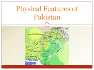
Location And Topography Of Pakistan Chapter:1 Environment of Pakistan 2059/2
CONTENTS INTRODUCTION LOCATION OF PAKISTAN Basic mapping tools NEIGHBOURING COUNTRIES OF PAKISTAN China Iran Afghanistan India GEOGRAPHY OF PAKISTAN LANDFORMS OF PAKISTAN IMPORTANCE OF PAKISTAN PHYSICAL FEATURES OF PAKISTAN
INTRODUCTION Ali Pakistan was created on 14 AUGUST,1947 by "Quaid-e-Azam Muhammad Jinnah". The boundary of Pakistan was demarcated by "Sir Cyril Radcliffe , on AUGUST 1947. 17 It was created on the basis of Islam and in order to protect the rights Muslim. of Pakistan is "Gate Way To Central Asia". Islamabad is the capital of Pakistan. Largest city of Pakistan is Karachi. Neighboring countries are China, India, Afghanistan, and Iran.
Location of Pakistan LOCATION: Continent: Asia Region: SouthAsia Latitude: 24`N-37`N Longitude: 61`E-78`E AREA: Total area: 796,096 km.sq Area : Ranked 36th Water:3.1% Land: 96.9% COASTLINE: Coastline: 1000km Highest point: K-2 (8,611m) Lowest point: Arabian sea(0 m)
Latitude and Longitude Lines of Latitude and Longitude are imaginary lines that encircle the Earth in either an East- West direction or in a North-South direction Together they form a grid which can be used to identify locations on the Earth s surface
Latitude and Longitude When using these lines to find a location the coordinates are always given latitude first and then longitude
Latitude and Longitude Using longitude and latitude to find a location you simply need to follow the lines until they meet at the point you arelooking for.
Neighbouring Countries Of Pakistan Following are the neighboring countries of Pakistan: China 1. Afghanistan 2. India 3. Iran 4.
China Border : 600km. i. China is located in the north of Pakistan. ii. iii. The name of the border is Khunjerab Pass. iv. Pakistan helped China to build a relation with world. the Muslim
Afghanistan Border: 2250 i. It is located in the west of Pakistan. ii. iii. The border of Pakistan and Afghanistan Durand Line. is named as iv. These two Asian states have deep historical and cultural links.
India Border: 1600km. i. ii. It is located in the East. iii. The name border is Border . of the named Pak-India as Wagah iv. India and Pakistan immediate countries Asia. are two South
Iran Border: 950 km. i. ii. It is located in the South-West. iii. The name of the border of Iran- Pakistan is Taftan border. iv. Pakistan and Iran is in bilateral relationship.
Geography Of Pakistan Pakistan is located in the region of South Asia, Subcontinent. The geography of Pakistan is a profound blend of landscapes, plains, deserts, forests etc. There are four provinces and two districtsof Pakistan; Punjab, Sindh, Baluchistan, Khyber Pakhtunkhwa and Gilgit, Baltistan. The capital of Pakistan is Islamabad.
Administration Division Punjab Baluchistan Khyber Pakhtunkhwa Sindh Gilgit Baltistan
END OF SLIDES. THANK YOU FOR YOUR ATTENTION