Understanding Ocean Salinity and Freezing Points

Explore the world of ocean salinity and freezing points, from the formation of polar ice to the unique characteristics of the Arctic and Antarctica. Discover the composition of ocean water, the concept of salinity, measurement methods, average ocean salinity levels, and how both saltwater and freshwater freeze. Dive into the intriguing process of freezing sea water and the formation of brine pockets within ice. Gain insights into the delicate balance of salt and fresh water in our oceans.

Download Presentation

Please find below an Image/Link to download the presentation.
The content on the website is provided AS IS for your information and personal use only. It may not be sold, licensed, or shared on other websites without obtaining consent from the author. Download presentation by click this link. If you encounter any issues during the download, it is possible that the publisher has removed the file from their server.
E N D
Presentation Transcript
Polar Ice Jeanine Gelhaus 8thgrade science unit Source: http://nsidc.org/cryosphere/seaice/c haracteristics/formation.html
Arctic or Antarctic Antarctica- "land surrounded by water Arctic - "water surrounded by land" Antarctica has penguins, no mosquitoes Arctic has polar bears, has mosquitoes But they both have something to do with oceans!
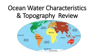
What does ocean water consist of? Salt and fresh water
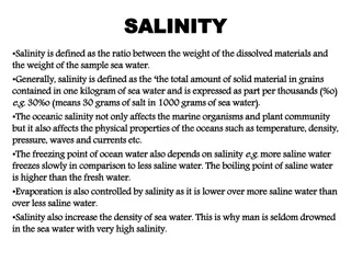
What is salinity? Salinity is a measure of the concentration of dissolved salts in water.
How do we measure salinity? A common way to define salinity values has been parts per thousand (ppt), or kilograms of salt in 1,000 kilograms of water. Today, salinity is usually described in practical salinity units (psu), a more accurate but more complex definition. Nonetheless, values of salinity in ppt and psu are nearly equivalent.
What is the average salinity of the ocean? The average salinity of the ocean typically varies from 32 to 37 psu, but in polar regions, it may be less than 30 psu. Sodium chloride (table salt) is the most abundant of the many salts found in the ocean
Does fresh water and salt water freeze at the same temperature? Fresh water freezes at 0 degrees Celsius (32 degrees Fahrenheit The freezing point of sea water varies. For every 5 ppt increase in salinity, the freezing point decreases by 0.28 degrees Celsius (0.5 degrees Fahrenheit) Thus, in polar regions with an ocean salinity of 35 ppt, the water begins to freeze at -1.8 degrees Celsius (28.8 degrees Fahrenheit).
The process of freezing sea water When frazil ice forms, salt accumulates into droplets called BRINE. The part of the ocean water that is FRESH WATER DOES FREEZE! When it does, tiny pockets of salt water are entrapped in the ice. As the water in these trapped pockets freezes, the dissolved salt resides in an increasingly smaller volume of water resulting in extremely salty water.
Brine Rejection Process The crystals begin to expel salt into the water. These BRINE pockets, under the influence of gravity, melt their way downward through the sea ice until they reach sea water. (Real world application: Just like when you put rock salt on your icy sidewalk) What remains is called FRAZIL crystals (consisting of nearly pure, FRESH WATER!) We will talk about this in the near future.
Brine Pockets A photograph in natural light showing elongated tubes that form as brine pockets trapped between the ice crystals. The image is 5 millimeters in width. Photo courtesy of Ted Maksym, United States Naval Academy.
Salt plays an important role in ocean circulation In cold, polar regions, changes in salinity affect ocean density more than changes in temperature. When salt is ejected into the ocean as sea ice forms, the water's salinity increases. Because salt water is heavier, the density of the water increases and the water sinks. The exchange of salt between sea ice and the ocean influences ocean circulation across hundreds of kilometers.
Brine Rejection Process These brine drops, being much saltier and, therefore, much denser than the surrounding sea water sink.
Brine Expelled http://www.bbc.co.uk/nature/15835017
Mystery Salinity Lab get supplies and lab sheet from teacher
What does Frazil Look Like? Small needle-like crystals are named frazil. Frazil is formed when ocean water begins to freeze. How small are these crystals? These crystals are typically 3 to 4 millimeters (0.12 to 0.16 inches) in diameter.
How do sheets of sea ice form? Frazil crystals float to the surface, accumulate and bond together.
Name two kinds of sheet ice GREASE or CONGELATION ICE PANCAKE ICE
Grease Ice Grease ice forms in calm waters. It develops into a continuous, thin sheet called nilas. Early in the freeze up season, the ice is somewhat mobile. As a result, they might fracture into smaller sheets. The nila ice might then flow or slide over other nilas due to currents and light winds. This process is called rafting.
Grease Ice At first, grease ice looks DARK, but it becomes lighter in color as it thickens. An overlapping blend of nila and smooth, snow-covered ice, with breakage around the edges, and fracturing on the surface. Credit: Ted Scambos, NSIDC
Congelation Ice When the grease ice thickens and becomes a stable sheet, it is then called congelation ice. The ice crystals in congelation ice are long and vertical because they grow slower than frazil ice. The ice has a smooth bottom surface.
Pancake Ice Pancake ice forms in rough, ocean water. These slushy, circular disks resemble pancakes. The perimeter has ridges or raised edges due to the pancakes bumping into each other in the rough water. Rafting can occur if the water is rough enough. If the ice is thick enough, it can pile on top of itself. This forms lines on the surface called ridges. The lines on the bottom of the ice are called Keel
WOW Moment In the Arctic, ridges up to 20 meters (60 feet) thick can form when thick ice deforms.
Cementing of the Ice After awhile, the pancakes cement together and consolidate into a coherent ice sheet. This ice has a very rough bottom.
Lets Contrast the Ice Sheets http://nsidc.org/cryosphere/seaice/characteristics/formation.html
Freezing Salt Water Lab- http://www.studyofplace.info/Activities/Activity.cfm?ActivityId=3&ActivityItemId=31
Research on Sea Ice Models (skillful numerical circulation model) Satellite Imagery
What kind of observations can scientists make concerning the ice http://www.oc.nps.edu/NAME/name.html This is a skillful numerical circulation model It provides context for interpreting limited observational data The model is able to reasonably reproduce observed conditions (such as ocean temperature, salinity, current speed and direction) at those locations where observations (measurements) exist. A utility of skillful numerical circulation models is that they provide context for interpreting limited observational data. If the model is skillful, then scientists and researchers have a measure of confidence that the model can reasonably represent conditions at locations where measurements do not exist.
Scientists use satellite images to study the ice This is the full mosaic of the arctic region (updated daily) http://rapidfire.sci.gsfc.nasa.gov/imagery/sub sets/?mosaic=Arctic.2013287.terra.4km
Lets compare two different dates: October 14, 2013 March 21st, 2012
Satellite image Oct. 14th, 2013 http://rapidfire.sci.gsfc.nasa.gov/imagery/subsets /?subset=Arctic_r04c02.2013287.terra Oct. 14, 2013 (you can see many large ice flows in this image) You can see open water in the fjords because it is early in the freeze up season. The ice is mobile and can easily be moved by wind/currents. As a result, the ice sheet fractures into smaller, unconsolidated flows.
Satellite image- March 31, 2012 http://rapidfire.sci.gsfc.nasa.gov/imagery/sub sets/?mosaic=Arctic.2012090.terra.4km March 31, 2012 Notice that there are still fractures in the sea ice cover, but the floes are much larger than those evident in the Oct. 14th, 2013 image
Cycle of sea ice Once sea ice forms into sheet ice, it continues to grow through the winter. When temperatures increase in spring and summer, the first-year ice begins to melt. If the ice does not grow thick enough over the winter, it will completely melt during the summer.
Ice Re-Freezing If a volume of sea ice grows enough during the winter and thins during the summer- but does not COMPLETELY melt during the summer and survives to re-freeze in subsequent winters, the resulting sea ice is termed multi-year (MY) sea ice.
Multi-Year Ice Multiyear ice. Image courtesy of Ted Maksym, United States Naval Academy.
Remote Sensing Remote sensing-means viewing something from a distance rather than by direct contact. Satellites can detect electromagnetic radiation from the multi-year ice. First-year and multiyear ice have different electromagnetic properties that satellite sensors can detect, allowing scientists to distinguish the two
Critical Thinking Because brine rejection in multi-year sea ice has occurred over multiple years, do you think the salinity of that ice would be more or less than first year (seasonal) sea ice?
Answer Because brine rejection in MY sea ice has occurred over multiple years, the bulk salinity of MY sea ice is less than that of first year (seasonal) sea ice. In fact, the salinity of older MY ice is sufficiently low that one can melt MY ice and drink the melt water. This is common practice for acquiring fresh water. MY sea ice looks similar to fresh water ice and is structurally much stronger than seasonal sea ice.
Critical Thinking What might be the consequence of our planet s warming and the volume of MY ice in the Arctic?
Answer A consequence of our warming planet is that the volume of MY ice in the Arctic is much less than it was a few decades ago.
Critical Thinking Why might Multiyear ice be much more common in the Arctic than in the Antarctic?
Answer Multiyear ice is much more common in the Arctic than in the Antarctic because ocean currents and atmospheric circulation move sea ice around Antarctica, causing most of the ice to melt in the summer as it moves into warmer waters, or as the upper ocean heats up due to absorption of solar heat by open water areas. Most of the multiyear ice that does occur in the Antarctic persists because of a circulating current in the Weddell Sea, on the eastern side of the Antarctic Peninsula. The Arctic Ocean, in contrast, is relatively land-locked, allowing extensive multiyear ice to form.
Environment and Climate Melting: The sun's rays strike the polar regions at a more grazing angle than over equatorial regions, where the rays strike at a more direct angle. The sun's angle is the primary reason why the polar regions are cold and the equatorial regions are warm.