Understanding Air Masses in Meteorology
Air masses play a significant role in meteorology, covering vast areas with uniform physical properties. They are classified based on temperature, moisture content, and source regions, which can be continental or maritime. Air masses form in regions with little wind and can sit over an area for an extended period, acquiring the characteristics of the surface below. Various processes like thermodynamic and dynamic modifications impact the properties of air masses, influencing weather patterns. Understanding the origin and characteristics of air masses is crucial for meteorological forecasting.
Download Presentation

Please find below an Image/Link to download the presentation.
The content on the website is provided AS IS for your information and personal use only. It may not be sold, licensed, or shared on other websites without obtaining consent from the author. Download presentation by click this link. If you encounter any issues during the download, it is possible that the publisher has removed the file from their server.
E N D
Presentation Transcript
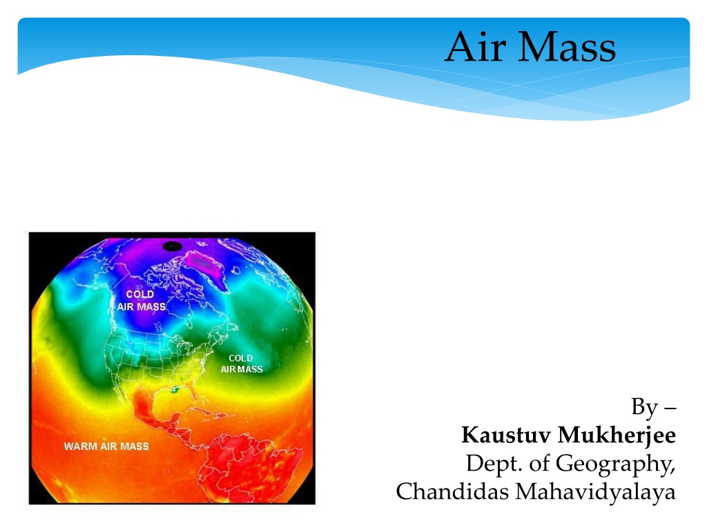
Air Mass By Kaustuv Mukherjee Dept. of Geography, Chandidas Mahavidyalaya
In its temperature and water vapor content. Air masses cover many hundreds or thousands of square miles, and adapt to the characteristics of the surface below them. They are classified according to latitude and their continental or maritime source regions. meteorology, an air mass is a volume of air defined by
Air Masses A body of air with more-or-less uniform physical properties over horizontal distances of hundreds of kilometres Temperature Moisture content lapse rate Input of heat and moisture to atmosphere is non-uniform. Creation of a uniform air mass achieved via: Mixing Radiative processes Time (3 7 days) Properties and degree of uniformity depend on: Source of the air History air mass modification Age of air mass
Source Regions If a large body of air sits over an area of land or water for a long period of time, it will take on the characteristics of the land or water beneath it this land or water area where air masses originate is called as Source Regions. *Air masses tend to form in areas with little wind. *Remember, they sit over an area for a long period of time without moving.
Source Regions Source Regions: areas of extensive uniform surface conditions situated below quasi-stationary high pressure systems.
Air Mass Modification Processes Thermodynamic Surface heating/cooling Change of temperature of surface, or advection over different surface Addition of moisture Surface evaporation Evaporation of precipitation falling from higher level Loss of moisture Condensation, precipitation Radiative heating/cooling slow compared to surface heat exchange (up to 2 weeks) Dynamic Turbulent mixing Increases uniformity of air mass. Very efficient close to surface. Large-scale lifting/descent Causes adiabatic changes of temperature May result in formation or evaporation of clouds 6
Location Air masses over the equator will have high temperatures. Air masses over polar regions will have low temperatures. Air masses over water (maritime) will have high humidity (moisture content). Air masses over land (continental) will have low humidity (moisture content).
Air Mass Classification Air masses are classified according to how they compare to the properties of the underlying surface and of adjacent air masses. 4 (sometimes 5) basic classifications combine source region and surface type: Maritime/marine (m) high moisture content Continental (c) typically low moisture Tropical (T) warm Polar (P) cold Also: Arctic (A) very cold Frequently indistinguishable from polar air masses in lower levels Originates over polar icecaps rather than high latitude land masses. Some classification schemes include indication of whether air is warmer (w) or cooler (k) than underlying surface after air mass modification has taken place; e.g. cPk, mPw. 8
Continental Polar (cP) Origin: continental anticyclones over Siberia and northern Canada during winter; Arctic basin (cA) when high pressure dominant. No sources of cP in southern hemisphere. Antarctica is a source of cA all year round. Snow covered surface of surface layers, equilibrium vapour pressure is low moisture content (0.1 to 0.5 g/kg). Cooling at surface stratification, limited mixing; allows further cooling by radiation resulting in very low temperatures. Subsidence of air aloft (and associated adiabatic warming) combined with radiative cooling at low levels pronounced inversion from surface to about 850 mb (~1 km). Low humidity results in generally low cloud amounts. cooling low Solar heating of land surface in summer removes source of cold air. stable
H Continental Polar (cP) Source: Siberia, very cold in winter, hot and dry in summer. Summer: Warm & dry, cloud free, except perhaps at east coast where cool & showery. Track: overland, short track over North Sea Winter: Snow near east coast; occasional snow showers in west. Very cold & strong easterly winds
Maritime Polar (mP) Origin: In northern hemisphere mP results primarily from modification of cP by flow over oceans: Siberia flowing over north Pacific, northern Canada & Greenland flowing over north Atlantic. In summer the Arctic icecap significant areas of melt water, and open leads in ice, provide effective water surface. In southern hemisphere: oceans surrounding Antarctica. In winter modified cA provides colder mP than modified cP. Cool and moist, extensive cloud cover. During initial flow over water, cP is warmed and moistened. High surface heat and moisture fluxes instability and strong convection; flow is very turbulent, increasing amounts of cumulus form, often in streets aligned with wind. Downwind, large cumulus organised in first closed, then open cells. Air mass now cool, moist mP, extensive cloud cover.
Maritime Polar (mP) Source: North Canada & Greenland. Very cold. L Summer: Heavy showers, thunderstorms over high ground. Winter: Heavy showers in north-west; clear skies in east at night giving frost. Dry in lee of mountains. Track: cool, moist, unstable
Returning Polar Maritime Source: North Canada. Very cold and dry Summer: Very warm, stratus clouds in southwest, squally showers & storms inland. L Winter: stratus cloud, showers over high ground, particularly in west. Track: warmer & wetter than mP ENVI 1400 : Meteorology and Forecasting : lecture 5 16
Arctic Maritime (mA) L Track: short; warm & moist at surface, cold aloft; unstable Source: Arctic seas / ice- cap. Very cold. Summer: Cold, frequent heavy showers. Winter: Very cold; strong winds from north and north- west. Heavy snow showers, particularly in north and coastal areas. Cold & bright in lake district and South Wales in lee of mountains to north.
Maritime Tropical (mT) Origin: Oceanic subtropical high pressure cells mid Atlantic (Azores High), much of pacific. 50% of southern hemisphere is a source of mT. High temperatures, and high humidity in lower layers. Stable or near neutral stratification. Modification of warm air is usually slow. Cooling from surface as air moves to higher latitudes results in formation of advection fog. If wind speed is high, mechanical mixing produces a deeper boundary layer (few hundred metres) and low stratiform cloud forms stratus or stratocumulus. Forced ascent at land can result in thick cloud and heavy rain. Advection fog, Golden Gate Bridge
Maritime Tropical (mT) L Source: warm tropical oceans Summer: Southwest winds; warm & sunny inland. Low stratus clouds round west coast. Winter: Stratus clouds/hill fog/drizzle clearing to the northeast. Warm, muggy, with prolonged rainfall in westerly mountains. Track: moist at surface H
Continental Tropical (cT) Origin: Continental parts of subtropical high pressure cells (e.g. north Africa) or regions of generally light, variable winds & subsidence in upper troposphere over major landmasses during summer (e.g. central Asia). Strong solar heating of land mass results in unstable stratification and strong convection. Low humidity coupled with subsidence means limits cloud development and preciptitation. In the northern hemisphere winter, north Africa is the only source of cT. Modification during transit over water (e.g. from N. Africa moving over Mediterranean into Europe): picks up lots of water vapour, lowering the density of humidified air and triggering strong convection. Large cumulus and thunderstorms form.
Continental Tropical (cT) Source: North Africa hot and dry. Summer only: Heatwave weather, hazy with occasional thunderstorm. H Track: overland with short sea track L
Summary Air masses are large regions of air with distinct properties Originate in high-pressure regions, and move towards low pressure Modified by changes in surface properties, and radiative warming/cooling
