Understanding Air Masses and Fronts in Weather Systems
Air masses play a crucial role in weather patterns, characterized by temperature and moisture content. They form over specific regions and influence weather conditions when they interact at fronts. Fronts are boundaries between air masses, such as cold fronts, warm fronts, occluded fronts, and stationary fronts, each bringing distinct weather phenomena. Understanding these concepts is essential for predicting and interpreting weather changes.
Download Presentation

Please find below an Image/Link to download the presentation.
The content on the website is provided AS IS for your information and personal use only. It may not be sold, licensed, or shared on other websites without obtaining consent from the author. Download presentation by click this link. If you encounter any issues during the download, it is possible that the publisher has removed the file from their server.
E N D
Presentation Transcript
AIR MASSES AND FRONTS 1
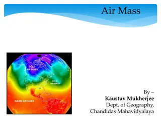
Air Masses Air masses take on the characteristics of the area where they form. Air mass temperature and moisture are consistent throughout. Warm air forms over tropical regions near the equator. T- Tropical Cold air forms over polar regions. P- Polar Wet air masses form over water m- maritime Dry air masses from over land. c- continental 2
Air masses Moisture content is noted by the first letter. m maritime wet c continental dry Temperature is noted by the second letter. P polar cool T tropical - warm 3
mP- maritime polar air mass cP continental polar air mass mT maritime tropical air mass cT continental tropical air mass 7
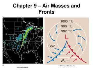
Fronts A front is a boundary between air masses. Four types of fronts and map symbols 1. Cold front 2. Warm front 3. Occluded front 4. Stationary front 8
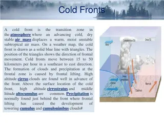
COLD FRONT Cold air mass meets a warm air mass and pushes the warm air mass out of its way. Bring thunderstorms, rain or snow. Most tornadoes develop from thunderstorms on the edge of a cold front. Cold front followed by cooler drier air. 9
WARM FRONT Warm air mass meets a cold air mass and pushes the cold air mass out of the way. Brings drizzly precipitation. Followed by clear warm weather. 10
STATIONARY FRONT Cold air meets warm air. Not enough force to move either front. Many days of cloudy, wet weather. 11
OCCLUDED FRONT Warm air caught between two cold air masses. Brings cool temperatures with large amounts of rain or snow 12
Cold Front, Warm Front and Occluded Front Animation http://www.3villagecsd.k12.ny.us/Murphy/me dina/weather.html http://www.classzone.com/books/earth_scien ce/terc/content/visualizations/es2002/es2002 page01.cfm?chapter_no=visualization Click on the above links. 13
Cyclone Area with lower pressure than surrounding area. Winds spiral toward the center. Rising air causes stormy weather. Hurricanes that from over the Indian Ocean are called cyclones. 15
Anticyclone Rotation of air around high pressure center. Dry, clear weather 16
Quiz: Take this on the paper provided. 1. Describe a maritime polar (mP) air mass, in terms of moisture and temperature. 2. What is the name of an air mass that forms over water? 3. What is the name of an air mass that forms over land? 4. What is the name of an air mass that forms in a cold region? 5. What is the name of an air mass that forms in a warm region? 6. Describe a continental tropical (cT) air mass, Moisture and temperature. 7. The boundary between two air masses is called a ______________________. 8. A cold air mass meets and pushes a warm air mass out of the way. What type of front am I? 9. A warm air mass is trapped between to cold air masses. What type of front am I? 10. A warm air mass meets and pushes a cold air mass out of the way. What type of front am I? 11. I am a front that brings drizzly rain and am followed by warm clear weather. Name me 12. A cold air mass meets a warm air but neither is very strong. They are separated and many days of wet , cloudy weather occur. 17
