Understanding REC and SEC Coordinates in Geodesy
Geodesist Boris Kanazir and NSRS Modernization Manager Dru Smith delve into the definitions, differences, and purposes of Reference Epoch Coordinates (RECs) and Survey Epoch Coordinates (SECs) at the 2021 Geospatial Summit. OPUS coordinates, SEC computation by NGS every four weeks, REC re-computation every 5 or 10 years, and the use of GNSS data in creating new coordinates are highlighted. The presentation emphasizes the importance of following OPUS recommendations for receiving coordinates tied to the NSRS.

Download Presentation

Please find below an Image/Link to download the presentation.
The content on the website is provided AS IS for your information and personal use only. It may not be sold, licensed, or shared on other websites without obtaining consent from the author. Download presentation by click this link. If you encounter any issues during the download, it is possible that the publisher has removed the file from their server.
E N D
Presentation Transcript
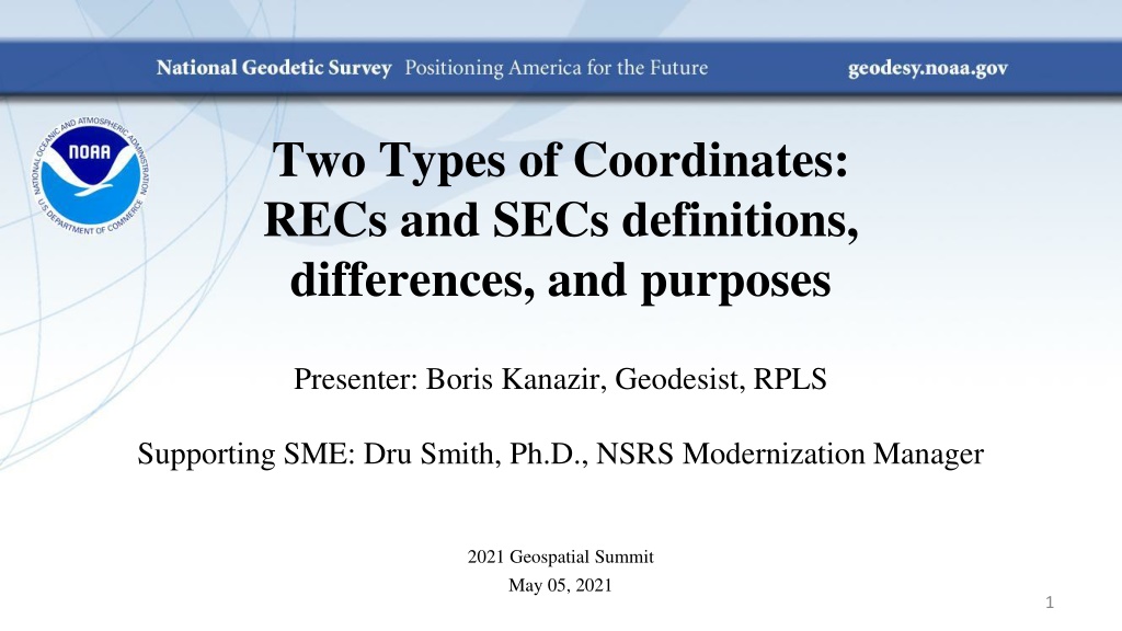
Two Types of Coordinates: RECs and SECs definitions, differences, and purposes Presenter: Boris Kanazir, Geodesist, RPLS Supporting SME: Dru Smith, Ph.D., NSRS Modernization Manager 2021 Geospatial Summit May 05, 2021 1
Outline 1. OPUS Coordinates 2. Survey Epoch Coordinates (SECs) 3. Reference Epoch Coordinates (RECs) Users in OPUS NGS 2
OPUS Coordinates Computed by users in OPUS Will not go into the NSRS, but the data behind them will Will be used by NGS to compute RECs and SECs If users follow OPUS recommendations, they will receive OPUS coordinates with the descriptor tied to the NSRS 3
Survey Epoch Coordinates (SECs) Computed by NGS every 4 weeks (tentative) Represent best estimate NGS has of the time- dependent coordinates at any mark They will be adjusted to a specific epoch near the survey They will show time dependency at marks 4
Reference Epoch Coordinates (RECs) They will be re-computed by NGS every 5 or 10 years Combining the same observations that were used to create SECs with IFVM2022 will allow NGS to estimate RECs Users are familiar with them as they work in a similar way to currently used NAD 83(2011) coordinates. 5
SEC = Survey Epoch Coordinates REC = Reference Epoch Coordinates IFVM = Intra-Frame Velocity Model SEC 2.250 SEC SEC 2.200 SEC REC REC REC h 2.150 2.100 IFVM 2.050 2.000 00 15 20 25 10 95 05 30 time 6
GNSS occupation data and its use in creating new coordinates 7
2030.00 AW n AW n+1 . . . . . . File 1, pt A File 2, pt B File 3, pt C File 4, pt A File 5, pt B File 6, pt C Survey Project X File 7, pt D File 8, pt B File 9, pt C File 10, pt D File 11, pt B File 12, pt C File 13, pt D File 14, pt B Survey Project Y Consider 2 different GNSS surveys: Survey X includes multiple 2-24 hour occupations on points A, B and C Survey Y includes multiple 2-24 hour occupations on points B, C and D Both surveys have data in Geometric Adjustment Window n and Geometric Adjustment Window n+1 8
2030.00 AW n AW n+1 . . . . . . File 1, pt A File 2, pt B File 3, pt C File 4, pt A File 5, pt B File 6, pt C Survey Project X Chosen epoch by manager of this survey project, at which the user will receive OPUS coordinates for points A, B and C With OPUS: - User defines their own adjustment epoch - User blends their data however they like File 7, pt D File 8, pt B File 9, pt C File 10, pt D File 11, pt B File 12, pt C File 13, pt D File 14, pt B Survey Project Y Chosen epoch by manager of this survey project, at which the user will receive OPUS coordinates for points B, C and D 10
2020.00 AW n AW n+1 . . . . . . File 1, pt A File 2, pt B File 3, pt C File 4, pt A File 5, pt B File 6, pt C Survey Project X File 7, pt D File 8, pt B File 9, pt C File 10, pt D File 11, pt B File 12, pt C File 13, pt D File 14, pt B Survey Project Y From the 2021 edition of Blueprint for the Modernized NSRS, Part 3: .with the midpoint epoch of a data file determining if a data file does or does not go into the [SEC adjustment] project 12
2030.00 AW n AW n+1 . . . . . . File 1, pt A File 2, pt B File 3, pt C File 4, pt A File 5, pt B File 6, pt C Survey Project X Epoch for SECs will always be the midpoint epoch of the Adjustment Window File 7, pt D File 8, pt B File 9, pt C File 10, pt D File 11, pt B File 12, pt C File 13, pt D File 14, pt B Survey Project Y This file is not used in AW n because its midpoint epoch falls in AW n+1 Data used to adjust SECs for AW n SECs created for points A, B, C and D 13
2030.00 AW n AW n+1 . . . . . . File 1, pt A File 2, pt B File 3, pt C File 4, pt A File 5, pt B File 6, pt C Survey Project X Epoch for SECs will always be the midpoint epoch of the Adjustment Window File 7, pt D File 8, pt B File 9, pt C File 10, pt D File 11, pt B File 12, pt C File 13, pt D File 14, pt B Survey Project Y Data used to adjust SECs for AW n+1 SECs created for points A, B, and D. With no data on C , no SEC is created for it in this AW. 14
2030.00 AW n AW n+1 . . . . . . File 1, pt A File 2, pt B File 3, pt C File 4, pt A File 5, pt B File 6, pt C Epoch for RECs will always be the reference epoch Survey Project #1 File 7, pt D File 8, pt B File 9, pt C File 10, pt D File 11, pt B File 12, pt C File 13, pt D File 14, pt B Survey Project #2 All of this data would go into the 2030.00 REC adjustment project, but reliance upon the IFVM will be important, especially for occupations in dynamic areas 16
Thank you! 17


")
")


")


")