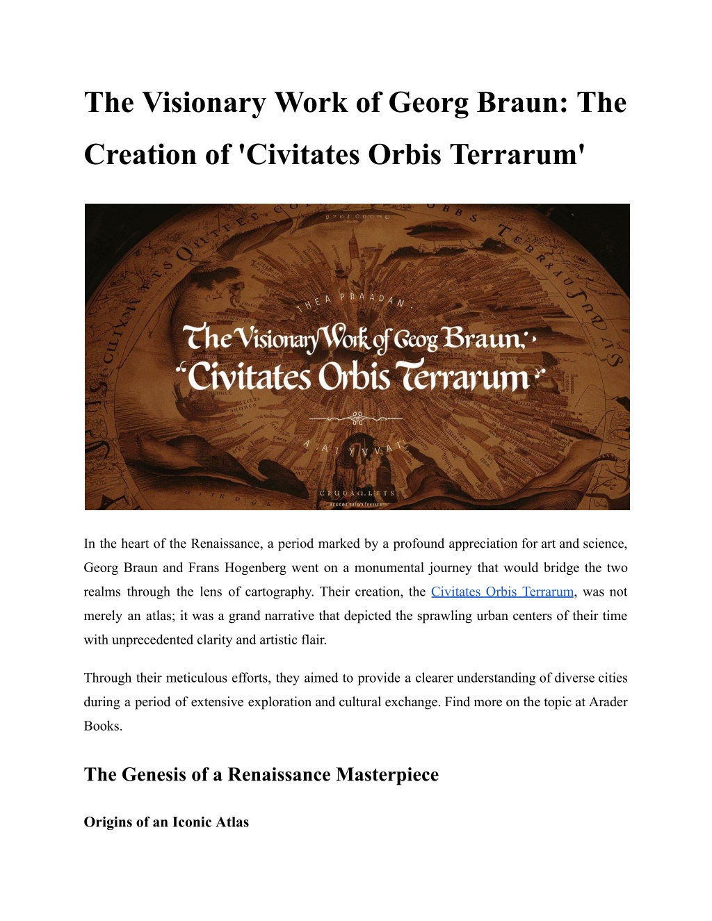
The Visionary Work of Georg Braun_ The Creation of 'Civitates Orbis Terrarum'
Discover how Georg Braun's vision led to the creation of 'Civitates Orbis Terrarum,' a groundbreaking city atlas.n

Download Presentation

Please find below an Image/Link to download the presentation.
The content on the website is provided AS IS for your information and personal use only. It may not be sold, licensed, or shared on other websites without obtaining consent from the author. Download presentation by click this link. If you encounter any issues during the download, it is possible that the publisher has removed the file from their server.
E N D
Presentation Transcript
The Visionary Work of Georg Braun: The Creation of 'Civitates Orbis Terrarum' In the heart of the Renaissance, a period marked by a profound appreciation for art and science, Georg Braun and Frans Hogenberg went on a monumental journey that would bridge the two realms through the lens of cartography. Their creation, the Civitates Orbis Terrarum, was not merely an atlas; it was a grand narrative that depicted the sprawling urban centers of their time with unprecedented clarity and artistic flair. Through their meticulous efforts, they aimed to provide a clearer understanding of diverse cities during a period of extensive exploration and cultural exchange. Find more on the topic at Arader Books. The Genesis of a Renaissance Masterpiece Origins of an Iconic Atlas
In 1572, Georg Braun and Frans Hogenberg embarked on a project that would redefine the standards of cartography with the release of the first volume. Inspired by earlier works like Sebastian M nster's Cosmographia, Braun aimed to create a companion piece to Abraham Ortelius's Theatrum Orbis Terrarum. Braun was profoundly influenced by his theological studies, which permeated the detailed descriptions accompanying each city map. Read More Article: The Making of 'The Birds of America': A Masterpiece of Ornithological Art Collaborative Genius Frans Hogenberg, a Flemish and German artist and engraver, played a crucial role as the chief engraver of the project. His artistic prowess, coupled with Braun's editorial direction, brought to life over 500 cities in exquisite detail. Hogenberg s background as a copper engraver and his collaborations with notable figures like Hieronymus Cock and Ortelius enriched the atlas, making it a product of the finest minds in cartography and art of the time. A Monumental Undertaking Creating the 6 volumes of Civitates Orbis Terrarum was an arduous process that spanned over 45 years. The effort required to coordinate over 100 artists and topographers illustrates the atlas' ambitious scope. Each city view was meticulously planned, incorporating not only geographical accuracy but also cultural elements that highlighted regional costumes and landmarks. Year Published Number of Plates Volume Notable Features First volume, includes cities like London and Paris; features bird's-eye views and detailed descriptions. Volume I 1572 59 Continues with more European cities; includes detailed engravings by Hogenberg. Volume II 1575 59
Expands to include cities from other continents; showcases cultural attire and landmarks. Volume III 1581 58 Features additional European cities; emphasizes the artistic style of the period. Volume IV 1588 59 Includes cities from Africa and Asia; introduces new engravers like Simon van den Neuwel. Volume V 1598 69 Final volume, completes the collection with a variety of global cities; reflects changes in urban landscapes over time. Volume VI 1617 58 Global and Cultural Richness Though centered on European cities, Braun Hogenberg Civitates Orbis Terrarum was pioneering in including places like Mexico City, Cuzco, and Calicut, presenting a broader view of the world than many contemporary maps. The detailed city plans were accompanied by rich descriptions in Latin, with subsequent editions translated into German and French, broadening their accessibility and impact. Artistic and Cartographic Mastery The artistic merit in this work is undeniable. Each plate is a work of art, showcasing not only the city's layout but also vignettes of daily life, making it a valuable source for both historians and art aficionados. The atlas stands out for its combination of technical cartography and engaging visual storytelling, a testament to the skills of Braun, Hogenberg, and their team. Read More Article: How to Replace a Stove Burner? Lasting Legacy Georg Braun's foresight in creating the Civitates Orbis Terrarum left an indelible mark on the field of cartography. This atlas is not merely a collection of maps; it is a comprehensive portrayal
of urban life in the Renaissance period, offering insights into the historical and cultural contexts of the time. Category Feature Description Bird's-Eye Panoramic Layouts Views and Comprehensive providing a detailed look at cities. views capture urban landscapes, Artistic Elements Detailed and decorative style typical of Dutch atlases, enhancing the aesthetic appeal. Flemish Engraving Style Rich Decorative Elements Detail and Includes heraldic arms, countryside depictions, and trade forms, offering a vivid picture of 16th-century life. Cultural and Daily Life Vignettes Showcases local customs, attire, and activities, offering insights into social and cultural aspects. Cultural Depictions Features traditional costumes, adding visual interest and preventing military use by the Turks due to Islamic prohibitions on human images. Inclusion Figures of Local Comprehensive Record Urban Oldest collection of cityscapes worldwide, mapping medieval cities before many were altered or destroyed. Historical Significance Set a new standard for urban depiction in cartography, influencing future atlases and remaining a key source for studying early modern landscapes. Influence and Legacy Combination Cartographic Detail and Artistry of Merges technical precision with engaging storytelling, making it both a technical achievement and an artistic masterpiece. Visual Storytelling A Cartographic Treasure This work remains a pivotal reference in historical and geographical studies. Its detailed illustrations and descriptions provide a vivid picture of 16th-century urban landscapes, bridging the gap between past and present. Georg Braun and Frans Hogenberg's collaborative work
continues to be celebrated for its artistic beauty and historical significance, a true masterpiece of Renaissance cartography. Georg Braun's visionary work - which you can find on Arader Books - not only advanced the science of map-making but also enriched our understanding of urban development and cultural diversity during a formative period in world history. As we leaf through the pages of this monumental atlas today, we are reminded of the enduring power of human curiosity and creativity. Site Article: The Visionary Work of Georg Braun: The Creation of 'Civitates Orbis Terrarum'