Unveiling Earth's Landform Patterns Through History

 
Understanding Landform
Patterns
 
 
Pop Quiz!
 
Anyone who can name 5 or more out of the 7
Physiographic Regions 
of Canada will get a
Prize!
You have 2 minutes
 
What Patterns have we already Scene?
 
Earthquakes
Tsunami
Volcanoes
 
Landform Patterns
 
Earthquakes and Volcanoes take place on or
near PLATE BOUNDARIES
Especially on the “Ring of Fire”


Landform Patterns
 
Everything on Earth exists there for a reason
Mountains
Rivers
Plateaus
Volcanoes
Plains
Different types of rock
We can examine these patterns in order to
understand WHY
 
Landform Patterns in History
 
During earth’s 4.6 Billion year history, pieces
of land have been built up and torn down
many times over
Scottish Geologist 
James Hutton
 first
advanced his idea in 1785.
Unfortunately, his theory was rejected, as
most scientists thought the earth was only
about 6000 years old.
Landform Patterns in History
 
In 1912, German Geographer 
Alfred Wegener
proposed that all of the continents were once
joined together in a huge land mass called…
Pangea
His theory was also criticized by scientists at
the time, but it led to the modern theory of
Plate Techtonics
Plate Techtonics
 
The theory that all 
Continents 
were once joined
together and are gradually drifting apart as the
Earth’s Plates 
move apart.
What are the 5 Continents?
North America
South America
Asia
Europe
Africa
Australia (Oceania)
Antarctica
 
Pangea 4.6 Billion Years Ago
 
 
Pangea 4.6 Billion Years Ago
 
 
Slowly Moves Apart
 
 
Modern Day 2019


Shields, Plains and LowLands
 
Change Over Time!
 
Pangea 
was built around “
Old Shield Regions
or “Old Plates”
The land was created from widespread
Volcano Eruptions Billions of years ago.
Therefore, originally, all of the 
Rock
 in Pangea
was this type of rock:
Igneous Rock (Volcanic Rock)
Solidified 
Magma 
from inside the Earth.
 
Igneous Rock
 
Change Over Time!
 
Later, over Millions of Years, heat and pressure
altered some part of these “Old Shield”
Regions
This formed this type of Rock:
Metamorphic Rock (Changed Rock)
Typically the 
Hardest 
types of rock
 
Metamorphic Rock


Shield Regions
 
As Pangea Broke apart over the years, the
Shield Regions 
were scattered across this
earth as the 
Core 
(Centre) of Continents
Today’s 
Shield 
regions are made up of a
combination of:
Igneous 
and 
Metamorphic 
rocks
This major “Physiographic Region” in Canada
is the:
Canadian Shield


Canadian Shield
 
Physiographic Regions
:  The process by which
regions with relatively homogeneous (
Similar)
physical geography are determined.
Today, shield regions are heavily worn, and
carved by the relentless forces of 
Erosion
through Water, Ice, and Wind
“Ancient Shield” such as the 
Canadian Shield
often have widespread areas of 
Bare Rock


Erosion
 
What is 
Erosion?
Erosion is the process by which the surface of
the Earth gets worn down.
Erosion can be caused by natural elements
such as wind and glacial ice.
But anyone who has ever seen a picture of the
Grand Canyon knows that nothing beats the
slow steady movement of water when it
comes to changing the Earth.
 
 
Change Over Time!
 
The 
Erosion 
 of the 
Shield 
regions created the
rest of the continent
Rivers 
and 
Glaciers 
carried eroded materials
called 
Sediment 
ancient seas
There, it accumulated into “thick, layered beds
which slowly solidified” to produce this type
of rock:
Sedimentary Rock (Layered Rock)
Sometimes you can even break the layers
apart with your bare hands!
 
Sedimentary Rock
 
Plains and Lowlands
 
New land emerged around the “Ancient
Shield” as the seas filled in
These are called 
Plains 
and 
Lowlands
They are underlaid by Horizontal layers of
Sedimentary 
rock
Plains 
are broad areas of level (flat) land
This major “Physiographic Region” in Canada
is called the:
Interior Plains
The Farmland there is called the:
Canadian Prairies


Interior Plains/ Canadian Prairies
 
 
Can see for km’s in the distance!
 
Lowlands
 
Lowlands 
are Plains that are located along
coastlines of seas, oceans, and lakes
For example, the major Canadian
Physiographic Region that we live in is called
the:
Saint Lawrence Lowlands
The other major Lowland Region is called the:
Hudson Bay Lowlands
They are both near large bodies of water!


Saint Lawrence Lowlands


Hudson Bay Lowlands


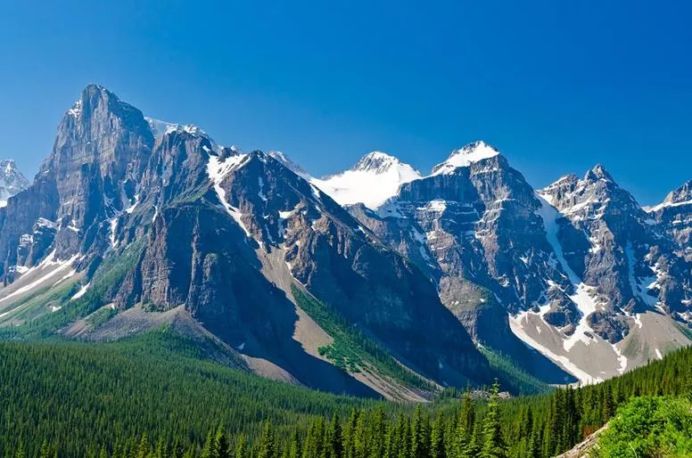
Fold Mountains
 
HUGE mountain chains cross continents in
bands
One chain runs the entire length of the West
Coast of North America and into South
America and Antarctica. This is called the:
Rocky Mountains
It is then called various different mountain
chains as it progresses into the U.S.A and
South America
It is however the exact same chain of
mountains all the way down!
 
Rocky Mountains
 
 
Fold Mountains
 
Massive mountain chains that spread
throughout the world
1. Runs down the 
West Coast 
of the Americas
from North to South
2. Crosses Europe and Asia from West to East
Fold Mountain Systems:
Huge crumpled ridges where plates collide
Built from think layers of 
Sedimentary Rock
deposited in ocean basins
Fold Mountain Regions
 
As currents in the 
Mantle 
drag plates
together, these layers are arched up in parallel
ridges; sort of like a 
Wrinkled Carpet
Rock cannot bend much, so the fold often
Snaps
, causing 
Earthquakes
 and movements
along cracks called 
Faults
 a famous fault is
called the:
San Andreas Fault in California
 
San Andreas Fault
 
 
Fold Mountain Regions
 
As a result of 
Earthquakes 
and 
Movement
Sedimentary 
rock layers have sometimes been
heaved up and stand on end
The pressure of the extreme folding has
created areas of 
Metamorphic 
rock in some
fold mountain regions
These mountains 
Divide the flow of Rivers
Elevation 
causes 
Climate Regions
, which in
turn create conditions for unique communities
of 
plants 
and 
animals
.


Fold Mountain Regions
 
 
Fold Mountains


Slide Note
Embed
Share

Explore the fascinating journey of Earth's landforms, from the formation of continents to the theory of Plate Tectonics. Delve into the rich history of geology, uncovering insights from notable scientists like James Hutton and Alfred Wegener. Witness the dynamic processes of earthquakes, volcanoes, and the shifting landscapes over billions of years. Experience the interconnected patterns of mountains, rivers, plateaus, and more that shape our planet's unique geography.

  • Earths Landforms
  • Geological History
  • Plate Tectonics
  • Geology Evolution
  • Continental Drift

Uploaded on Sep 16, 2024 | 0 Views


Download Presentation

Please find below an Image/Link to download the presentation.

The content on the website is provided AS IS for your information and personal use only. It may not be sold, licensed, or shared on other websites without obtaining consent from the author. Download presentation by click this link. If you encounter any issues during the download, it is possible that the publisher has removed the file from their server.

E N D

Presentation Transcript


  1. Understanding Landform Patterns

  2. Pop Quiz! Anyone who can name 5 or more out of the 7 Physiographic Regions of Canada will get a Prize! You have 2 minutes

  3. What Patterns have we already Scene? Earthquakes Tsunami Volcanoes

  4. Landform Patterns Earthquakes and Volcanoes take place on or near PLATE BOUNDARIES Especially on the Ring of Fire

  5. Landform Patterns Everything on Earth exists there for a reason Mountains Rivers Plateaus Volcanoes Plains Different types of rock We can examine these patterns in order to understand WHY

  6. Landform Patterns in History During earth s 4.6 Billion year history, pieces of land have been built up and torn down many times over Scottish Geologist James Hutton first advanced his idea in 1785. Unfortunately, his theory was rejected, as most scientists thought the earth was only about 6000 years old.

  7. Landform Patterns in History In 1912, German Geographer Alfred Wegener proposed that all of the continents were once joined together in a huge land mass called Pangea His theory was also criticized by scientists at the time, but it led to the modern theory of Plate Techtonics

  8. Plate Techtonics The theory that all Continents were once joined together and are gradually drifting apart as the Earth s Plates move apart. What are the 5 Continents? North America South America Asia Europe Africa Australia (Oceania) Antarctica

  9. Pangea 4.6 Billion Years Ago

  10. Pangea 4.6 Billion Years Ago

  11. Slowly Moves Apart

  12. Modern Day 2019

  13. Shields, Plains and LowLands

  14. Change Over Time! Pangea was built around Old Shield Regions or Old Plates The land was created from widespread Volcano Eruptions Billions of years ago. Therefore, originally, all of the Rock in Pangea was this type of rock: Igneous Rock (Volcanic Rock) Solidified Magma from inside the Earth.

  15. Igneous Rock

  16. Change Over Time! Later, over Millions of Years, heat and pressure altered some part of these Old Shield Regions This formed this type of Rock: Metamorphic Rock (Changed Rock) Typically the Hardest types of rock

  17. Metamorphic Rock

  18. Shield Regions As Pangea Broke apart over the years, the Shield Regions were scattered across this earth as the Core (Centre) of Continents Today s Shield regions are made up of a combination of: Igneous and Metamorphic rocks This major Physiographic Region in Canada is the: Canadian Shield

  19. Canadian Shield Physiographic Regions: The process by which regions with relatively homogeneous (Similar) physical geography are determined. Today, shield regions are heavily worn, and carved by the relentless forces of Erosion through Water, Ice, and Wind Ancient Shield such as the Canadian Shield often have widespread areas of Bare Rock

  20. Erosion What is Erosion? Erosion is the process by which the surface of the Earth gets worn down. Erosion can be caused by natural elements such as wind and glacial ice. But anyone who has ever seen a picture of the Grand Canyon knows that nothing beats the slow steady movement of water when it comes to changing the Earth.

  21. Change Over Time! The Erosion of the Shield regions created the rest of the continent Rivers and Glaciers carried eroded materials called Sediment ancient seas There, it accumulated into thick, layered beds which slowly solidified to produce this type of rock: Sedimentary Rock (Layered Rock) Sometimes you can even break the layers apart with your bare hands!

  22. Sedimentary Rock

  23. Plains and Lowlands New land emerged around the Ancient Shield as the seas filled in These are called Plains and Lowlands They are underlaid by Horizontal layers of Sedimentary rock Plains are broad areas of level (flat) land This major Physiographic Region in Canada is called the: Interior Plains The Farmland there is called the: Canadian Prairies

  24. Interior Plains/ Canadian Prairies

  25. Can see for kms in the distance!

  26. Lowlands Lowlands are Plains that are located along coastlines of seas, oceans, and lakes For example, the major Canadian Physiographic Region that we live in is called the: Saint Lawrence Lowlands The other major Lowland Region is called the: Hudson Bay Lowlands They are both near large bodies of water!

  27. Saint Lawrence Lowlands

  28. Hudson Bay Lowlands

  29. Fold Mountains HUGE mountain chains cross continents in bands One chain runs the entire length of the West Coast of North America and into South America and Antarctica. This is called the: Rocky Mountains It is then called various different mountain chains as it progresses into the U.S.A and South America It is however the exact same chain of mountains all the way down!

  30. Rocky Mountains

  31. Fold Mountains Massive mountain chains that spread throughout the world 1. Runs down the West Coast of the Americas from North to South 2. Crosses Europe and Asia from West to East Fold Mountain Systems: Huge crumpled ridges where plates collide Built from think layers of Sedimentary Rock deposited in ocean basins

  32. Fold Mountain Regions As currents in the Mantle drag plates together, these layers are arched up in parallel ridges; sort of like a Wrinkled Carpet Rock cannot bend much, so the fold often Snaps, causing Earthquakes and movements along cracks called Faults a famous fault is called the: San Andreas Fault in California

  33. San Andreas Fault

  34. Fold Mountain Regions As a result of Earthquakes and Movement Sedimentary rock layers have sometimes been heaved up and stand on end The pressure of the extreme folding has created areas of Metamorphic rock in some fold mountain regions These mountains Divide the flow of Rivers Elevation causes Climate Regions, which in turn create conditions for unique communities of plants and animals.

  35. Fold Mountain Regions

  36. Fold Mountains

More Related Content

giItT1WQy@!-/#giItT1WQy@!-/#giItT1WQy@!-/#