Understanding Applied Geomorphology for Sustainable Environmental Management

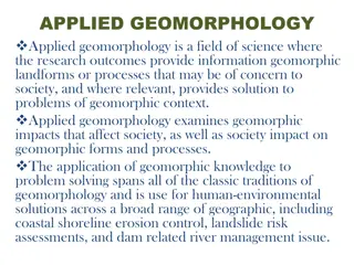
Applied geomorphology plays a crucial role in urban planning, natural hazard mapping, land use planning, and environmental management. By applying geomorphic knowledge, problems related to land occupancy, resource exploitation, and environmental planning can be analyzed and solved effectively. Geomorphologists study the impact of natural processes on human activities, manage resources, and suggest remedial measures for sustainable development.

Download Presentation

Please find below an Image/Link to download the presentation.
The content on the website is provided AS IS for your information and personal use only. It may not be sold, licensed, or shared on other websites without obtaining consent from the author. Download presentation by click this link. If you encounter any issues during the download, it is possible that the publisher has removed the file from their server.
E N D
Presentation Transcript
GOVERNMENT COLLEGE FOR WOMEN (AUTONOMOUS) KUMBAKONAM DEPARTMENT OF GEOGRAPHY I M.Sc - GEOGRAPHY APPLIED GEOMORPHOLOGY - UNIT:V APPLIED GMORPHOLGY MEANING AND APPLICATIONS
UNIT: V UNIT: V APPLIED GEOMORPHOLOGY APPLIED GEOMORPHOLOGY - - P18GC101 APPLIED GEOMORPHOLOGY APPLIED GEOMORPHOLOGY - - MEANING AND APPLICATIONS MEANING AND APPLICATIONS P18GC101 What is Applied Geomorphology? Applied geomorphology in this aspect can be of use in urban planning in different geomorphic environments and in preparation of natural hazard maps, morpho-agricultural regionalisation, land use planning, construction and management of roads. According to D.K.C. Jones, applied geomorphology could be defined as the application of geomorphic understanding to the analysis and solution of problems concerning land occupancy, resource exploitation, and environmental management and planning .
What is the Scope of Geomorphology? Our journal's scope includes geomorphic themes of: tectonics and regional structure; glacial processes... Geomorphology publishes peer-reviewed works across the full spectrum of the discipline from fundamental theory and science to applied research of relevance to sustainable management of the environment. An understanding of landforms may be of great use, directly or indirectly, to human beings who are influenced by and, in turn, influence the surface features of the earth which they inhabit. If landforms are properly interpreted, they throw light upon the geologic history, structure and litho logy of a region. According to D.K.C. Jones, applied geomorphology could be defined as the application of geomorphic understanding to the analysis and solution of problems concerning land occupancy, resource exploitation, and environmental management and planning .
Indeed, all geomorphological knowledge tends to be applied, according to R.G. Craig and J.L. Craft. As each advance in knowledge provides a clear view of how the earth works, geomorphologists can make use of the knowledge for evaluating resources, development projects, locating natural hazards and mitigating the effect of natural disasters. Geomorphic knowledge and techniques may be applied in the following areas: i. Studying the impact of geomorphic/ environmental processes on human society and activities and dealing with problems arising out of such impact; ii. Investigating the changes brought about in the geomorphic/environmental processes by human activities and dealing with the problems arising out of such interaction; iii. Managing resources and monitoring changes in the geomorphic system to suggest suitable remedial measures for maintaining development at a sustainable level.
Two Main Lines of Application: The application of Geomorphology, according to Charley, Schumn and Sugden, may be considered along two lines: (i) Geomorphology can be an aid to resource evaluation, engineering construction and planning. In this category we may put resource inventories, environmental management, soil and land evaluation, production of maps for hydrological, erosional and stability control, geomorphic mapping, mapping for land systems and evaluating terrain, classification and retrieval of information on terrain and other matters of use to earth scientists, engineers and planners. Applied geomorphology in this aspect can be of use in urban planning in different geomorphic environments and in preparation of natural hazard maps, morpho-agricultural regionalisation, land use planning, construction and management of roads.
(ii) Applied geomorphology is also concerned with human beings as geomorphic agents, in terms of their planned or inadvertent effects on geomorphic processes and forms. Human beings have over time tried to tame and modify geomorphic/environmental processes to suit their economic needs. Embankments have been built to check flooding of rivers; meandering courses of rivers have been straightened and channels diverted; coastal areas have been sought to be protected against wave erosion by building walls; there have been attempts to stabilise sandy areas through plantation, and check soil erosion through afforestation. These are some examples of planned activities by human beings that have an impact on geomorphic forms and processes.
The inadvertent effects of human activities on geomorphic forms and processes are many: forests are cleared and grasslands burnt for cultivating crops or for building settlements; mining activities and water extraction cause subsidence of land; building and mining activities result in modification of terrain; excessive, unplanned deforestation causes accelerated soil erosion and increase in sediment load leading, in turn, to recurrent floods and riparian decay. Pollution has been a major inadvertent effect of human economic activity. Dams cause changes in river load and accelerated erosion. High altitude construction has modified permafrost.
Specific Applications: We consider here some of the applications of geomorphology to the types of problems commonly encountered by geologists, engineers and planners. Geomorphology and Hydrology: Water used by human beings is available from different sources streams, lakes and rivers on the surface of the earth or groundwater. Different stratigraphic and lithological zones present different conditions of surface and groundwater. Limestone terrains vary widely and the ability to yield water depends on the type of rock. Permeability in limestones may be primary or secondary. Primary permeability depends upon the presence of initial interconnecting voids in the calcerous sediments from which the rock was formed. Secondary (or acquired) permeability occurs because of earth movements such as faulting, folding, warping, and due to solution or corrosion mechanism.
This secondary permeability varies notably with respect to the topography of a region, being greatest beneath and adjacent to topographic lows or valleys. Much of the groundwater in karst terrain is confined to solution channels. In early stages of karst evolution conditions are not too different from those of other types of landscapes with similar relief. But as the cycle advances, a large proportion of water is diverted to solutionally opened passageways, and surface water gets diminished. The main source of water in such regions then are karst springs. Such springs may supply water to meet moderate demands, but the quality of water may be affected by pollutants and bacteria. The sources of the spring water should be determined in such a case of pollution. The swallow holes and sinkholes feeding water to the underground drainage systems emerging as springs may be located. This can be done by putting some colouring material, such as fluorescein, into the water entering nearby swallow holes (or sinkholes) and testing the various spring waters to find out their source. A knowledge of the structural geology of the region is of use in this context, as groundwater moves down rather than up the regional dip.
The ease with which water may be obtained in a limestone region depends on the geomorphology of the area. If the limestones have enough permeability and are capped by sandstone layer, there may be no difficulty in obtaining wells of large yields. Moreover, the water would get naturally filtered as it passes through the sandstone beds. If, however, the limestone is dense and compact, with little mass permeability, movement of groundwater will be largely through secondary openings. In such circumstances, the yield of water may be low or, even if adequate, subject to contamination. Karst plains lack a filtering cover and sinkholes, swallow holes or karst valleys within an area of clastic rocks should cast doubt on the purity of the water from springs nearby. Groundwater potential in glaciated regions can be determined on the basis of understanding the geomorphic history of the area, characteristics of glacial deposits and landform. Outwash plains, valley trains and intertill gravels are likely to yield large volumes of water. Most tills are poor sources of water because of the clay in them, but they contain local strata of sand and gravel which may hold and supply enough water for domestic needs.
Groundwater potential in glaciated regions can be determined on the basis of understanding the geomorphic history of the area, characteristics of glacial deposits and landform. Outwash plains, valley trains and intertill gravels are likely to yield large volumes of water. Most tills are poor sources of water because of the clay in them, but they contain local strata of sand and gravel which may hold and supply enough water for domestic needs. Buried preglacial and interglacial valleys could be good sources of groundwater. Their presence (or absence) may be detected by studying the preglacial topography and geomorphic history of the area. Buried valleys are located by constructing bedrock topography maps of glaciated areas.
Geomorphology and Mineral Exploration Mineral deposits are associated with geological structure. Landscape characteristics of the specific localities could indicate such geological structures. Surface Expression of Ore Bodies: Some ore bodies have obvious surface expressions as topographic forms, as outcrops of ore, gossan, or residual minerals, or structural features such as faults, fractures and zones of breccia. Lead-zinc lodes could be marked by a conspicuous ridge as in the case of Broken Hill, Australia.
Quartz veins could stand out prominently as they are much more resistant to erosion than the unsilicified surroundings, as in Chihuahua, Mexico. Some veins (calcite, for instance) and mineralised areas may be indicated by depressions or subsidence features. Application of Geomorphology in Mineral Prospecting Geomorphic features may be helpful in locating mineral deposits in various ways. Mineral deposits are associated with geological structure. Landscape characteristics of the specific localities could indicate such geological structures. Geomorphology can play an important role for several important economic minerals which are essentially weathering residues of present or ancient geomorphic cycles. Apart from iron deposits, materials like clay minerals, caliche, bauxite and some manganese and nickel ores are of this nature.
Weathering Residues: Many economically important minerals are the weathering residues of present or ancient geomorphic cycles and geomorphology can be of use in searching for such minerals. Iron ore, clay minerals, caliche, bauxite and some ores of manganese and nickel may be such weathering residues. Weathering and erosion are constantly at work on the rocks of earth s surface, and the products of rock weathering may be of economical value. The surfaces on which residual weathering products commonly form are pleneplain or near-pleneplain surfaces. Such minerals are more commonly to be found upon remnants of Tertiary erosional surfaces above present base levels of erosion. Bauxite, for instance, is either the residue of a small amount of insoluble aluminous material in dolomites and limestones or it is the direct product of the weathering of aluminous minerals.
Placer Deposits: Placer deposits are mixtures of heavy metals which are aggregates of materials derived through chemical weathering or erosion of metallic formation. Placer concentration of minerals results from definite geomorphic processes and, found in specific topographical positions, may have a distinctive topographic expression. The type of rock forming the bedrock floor may influence the deposition of placers. Residual placers or seam diggings are residues from the weathering of quartz stringers or veins, are usually of limited amount, and grade down into lodes. Colluvial placers are produced by creep downslope of residual materials and are thus transitional between residual placers and alluvial placers.
Gold placers of this type have been found in California, Australia, New Zealand, and elsewhere. Part of the tin placers of Malaya is colluvial placers (the koelits) and parts are alluvial placers (the kaksas). About one-third of the world s platinum is obtained from alluvial placers in Russia, Colombia, and elsewhere. Gold, tin and diamonds are among the more important minerals obtained from alluvial placers. Diamonds in the Vaal and Orange River districts of South Africa, the Lichtenburg area of South Africa, the Belgian Congo, and Minas Geraes, Brazil, are obtained from alluvial placers. About 20 per cent of the world s diamonds comes from placer deposits. Aeolian placers have yielded gold in Australia and Lower California, Mexico. Bajada placers form in the gravel mantle of a pediment and in the confluent alluvial fans of a bajada.
They are more likely to be found near a mountain base than out on the more gentle slopes of a basin fill. Beach placers have yielded gold in California and Alaska, diamonds in the Namaqualand district of South Africa, zircon in India, Brazil, and Australia, and ilmenite and monazite in Travancore, India. Location of placers may be aided by drilling and geophysical testing. A magnetic survey will usually be helpful because magnetite is likely to be associated with gold. If the bedrock is a basic type with a higher magnetic intensity than the placer gravels, areas of magnetic lows may reflect the positions of the filled channels. Knowledge of the bedrock geology, application of geophysical surveying, test drilling and aerial- photograph interpretation all contribute their parts to exploration for these buried placers, but most fundamental to this search is a thorough understanding of the geomorphic history of the region, observes W.D. Thornbury.
Oil Exploration Many oil fields have been discovered because of their striking topographic expression. Mineral oil is considered to have been formed by the decay and decomposition of organic matter. After formation, this oil gets trapped in rocks under structural traps or stratigraphic traps. Sedimentary strata are folded into anticlines and synclines allowing the permeable and impermeable strata to get closer, and the mineral oil are well-preserved within the upper permeable and the lower impermeable beds. Generally mineral oil is found in the porous and permeable rock structures with lower layers of impermeable rocks. Sandstone and limestone provide ideal locations of mineral oil as they are porous and permeable. The shale below acts as the impermeable bed. In regions of heavy tropical forests, where topography cannot be seen through the forest, tonal differences may indicate an anticlinal or domal structure.
More subtle evidence of geologic structures favourable to oil accumulation is being made use of today in the search for oil. Drainage analysis of a terrain shown on aerial photography is one such technique. A sophisticated perception of drainage anomalies of an area is required, and a geomorphologist would most likely possess the requisite knowledge. Drainage analysis is particularly useful in regions where rocks have low dips and the topographic relief is slight. According to Leverson, many oil and gas sources are associated with unconformities ancient erosion surfaces; hence a petroleum geologist must deal with buried landscapes. Where ancient erosion surfaces shorten permeable beds and are later sealed over by deposits, the erosion surfaces become stratigraphic traps, most of which are along unconformities.
Thank you Thank you
 KUMBAKONAM")


 Applied geomorphology is also concerned with human")