South Carolina's Geography and Human Systems
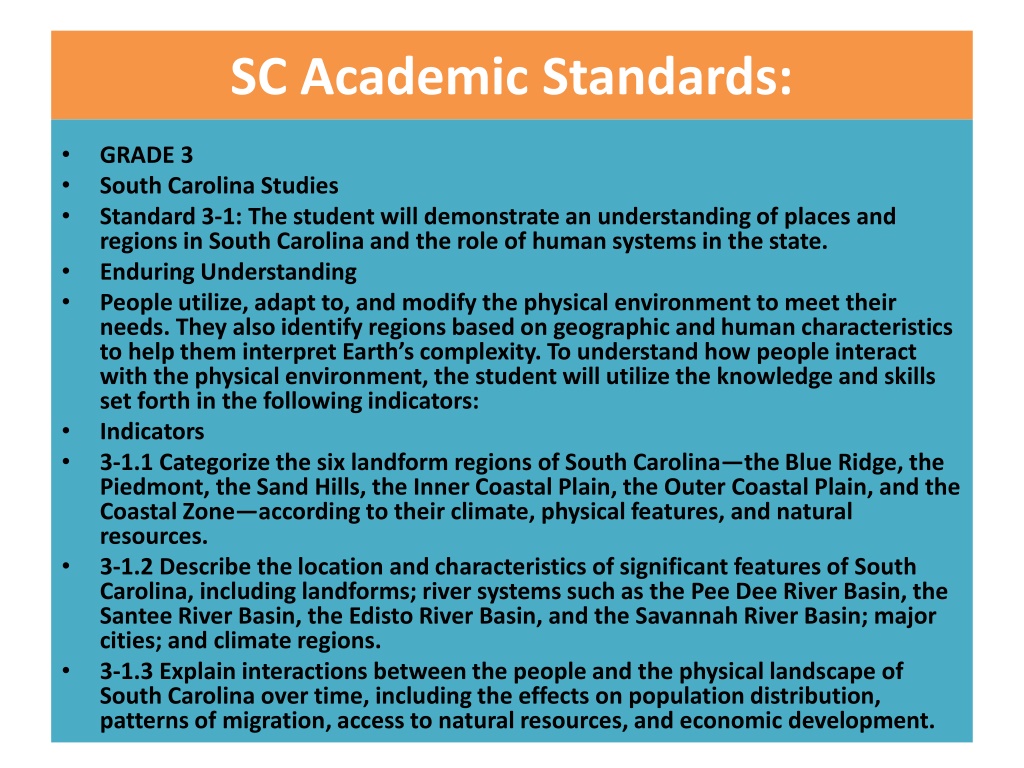
SC Academic Standards:
•
GRADE 3
•
South Carolina Studies
•
Standard 3-1: The student will demonstrate an understanding of places and
regions in South Carolina and the role of human systems in the state.
•
Enduring Understanding
•
People utilize, adapt to, and modify the physical environment to meet their
needs. They also identify regions based on geographic and human characteristics
to help them interpret Earth’s complexity. To understand how people interact
with the physical environment, the student will utilize the knowledge and skills
set forth in the following indicators:
•
Indicators
•
3-1.1 Categorize the six landform regions of South Carolina—the Blue Ridge, the
Piedmont, the Sand Hills, the Inner Coastal Plain, the Outer Coastal Plain, and the
Coastal Zone—according to their climate, physical features, and natural
resources.
•
3-1.2 Describe the location and characteristics of significant features of South
Carolina, including landforms; river systems such as the Pee Dee River Basin, the
Santee River Basin, the Edisto River Basin, and the Savannah River Basin; major
cities; and climate regions.
•
3-1.3 Explain interactions between the people and the physical landscape of
South Carolina over time, including the effects on population distribution,
patterns of migration, access to natural resources, and economic development.
Name and Label 4 River Cities
In South Carolina
Four Cities & Four Rivers
•
Columbia
Broad & Saluda
Rivers
•
Camden
Catawba River
•
Cheraw
Pee Dee River
•
North Augusta
Savannah River
Draw a line Connecting the Citie
s
Columbia *
Camden
*
Cheraw *
North
Augusta
*
What Is the Line Called?
Columbia *
Camden
*
Cheraw *
North
Augusta
*
Regions of South Carolina
Fa
llLine
Sand Hills
SC Fall Line River Cities
Fa
llLine
Cheraw
Camden
Columbia
North
Augusta
Sand Hills
Name and 2 more SC rivers.
Edisto
River
Santee
River
Explore South Carolina's diverse landform regions, river systems, major cities, and interactions between people and the physical landscape. Learn about the significance of Cheraw, Camden, Columbia, and North Augusta along the Fall Line and Sand Hills regions, as well as the Santee River and Edisto River. Discover how humans utilize, adapt to, and modify the environment to meet their needs in the state of South Carolina.

Download Presentation

Please find below an Image/Link to download the presentation.
The content on the website is provided AS IS for your information and personal use only. It may not be sold, licensed, or shared on other websites without obtaining consent from the author.If you encounter any issues during the download, it is possible that the publisher has removed the file from their server.
You are allowed to download the files provided on this website for personal or commercial use, subject to the condition that they are used lawfully. All files are the property of their respective owners.
The content on the website is provided AS IS for your information and personal use only. It may not be sold, licensed, or shared on other websites without obtaining consent from the author.
E N D
Presentation Transcript
SC Academic Standards: GRADE 3 South Carolina Studies Standard 3-1: The student will demonstrate an understanding of places and regions in South Carolina and the role of human systems in the state. Enduring Understanding People utilize, adapt to, and modify the physical environment to meet their needs. They also identify regions based on geographic and human characteristics to help them interpret Earth s complexity. To understand how people interact with the physical environment, the student will utilize the knowledge and skills set forth in the following indicators: Indicators 3-1.1 Categorize the six landform regions of South Carolina the Blue Ridge, the Piedmont, the Sand Hills, the Inner Coastal Plain, the Outer Coastal Plain, and the Coastal Zone according to their climate, physical features, and natural resources. 3-1.2 Describe the location and characteristics of significant features of South Carolina, including landforms; river systems such as the Pee Dee River Basin, the Santee River Basin, the Edisto River Basin, and the Savannah River Basin; major cities; and climate regions. 3-1.3 Explain interactions between the people and the physical landscape of South Carolina over time, including the effects on population distribution, patterns of migration, access to natural resources, and economic development.
Name and Label 4 River Cities In South Carolina
Four Cities & Four Rivers Columbia Broad & Saluda Rivers Camden Catawba River Cheraw Pee Dee River North Augusta Savannah River
Draw a line Connecting the Cities Cheraw * Camden * Columbia * North Augusta *
What Is the Line Called? Cheraw * Camden * North Augusta Columbia * *
Regions of South Carolina FallLine Sand Hills
SC Fall Line River Cities Cheraw Camden FallLine Columbia North Augusta Sand Hills
Name and 2 more SC rivers. Santee River Edisto River