Lithologic Units in Modern Basins & Landscape History
Mapping and analyzing the lithologic units in six modern basins in the research area, with a focus on the history of the landscape and geologic formations, including the composition and depositional environments of important formations such as Aldrich Station and Coal Valley. Structural information and rock ages provide a comprehensive view of the region's geological evolution.

Download Presentation

Please find below an Image/Link to download the presentation.
The content on the website is provided AS IS for your information and personal use only. It may not be sold, licensed, or shared on other websites without obtaining consent from the author.If you encounter any issues during the download, it is possible that the publisher has removed the file from their server.
You are allowed to download the files provided on this website for personal or commercial use, subject to the condition that they are used lawfully. All files are the property of their respective owners.
The content on the website is provided AS IS for your information and personal use only. It may not be sold, licensed, or shared on other websites without obtaining consent from the author.
E N D
Presentation Transcript
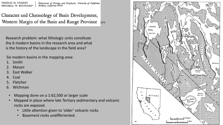
1973 Research problem: what lithologic units constitute the 6 modern basins in the research area and what is the history of the landscape in the field area? Six modern basins in the mapping area: 1. Smith 2. Mason 3. East Walker 4. Coal 5. Fletcher 6. Wichman Mapping done on a 1:62,500 or larger scale Mapped in place where late Tertiary sedimentary and volcanic rocks are exposed. Little attention given to older volcanic rocks Basement rocks undifferiented.
Important geologic context Regional basement consists of granitic, metavolcanic, and metasedimentary rocks of Mesozoic age. Older volcanic rocks: ~30-12 Ma rocks Ignimbrite flows, andesitic flows, breccia Upper Miocene and Pliocene Sedimentary formations (3 important units compose the Wassuk Group) Aldrich Station formation (12.5-11 Ma) Coal Valley formation (11-9 Ma) Morgan Ranch formation (estimated 9-7.5 Ma) Younger volcanic rocks- volcanic units seen within the Wassuk Group. (12.5- ~5.0 Ma) Youngest Sedimentary Deposits and erosional surfaces (<5 Ma)
Important formations: Wassuk Group Aldrich Station formation Composed of carbonaceous mudstone, siltstone, shale, and arenite (sand-sized grain) beds. Deposited in an alternating lacustrine and fluviatile environments. Unconformable contact with older andesite flows Uniform fine-grained rocks indicate nearly continuous deposition in a basin surrounded by low-relief Mapped margins indicate a basin with a northwest direction
Important formations: Wassuk Group Coal Valley formation Most widespread of Wassuk Group formations- outcrops in 5 separate basins Composed of andesitic sandstone, pebble and cobble conglomerates, mudstone, and siltstone Origin is lacustrine to fluvial Lies unconformably on older units Deposited in a basin, much larger than its present expanse. Basin margins are unknown Basin had an elongate northwest shape
Important formations: Wassuk Group Morgan Ranch formation Consists of coarse clastic sediments overlying the Coal Valley formation Relationship between Morgan Ranch and Coal Valley formations is variable and exposed contacts are usually faults, but the contact can also be seen in the field as conformable Depositional setting: colluvium deposited in front of a tectonically rising basement block. More distal areas, finer grained, are related to a subsiding fault block.
Pertinent Structural Information Faulting pre-7.5 Ma produced structurally low areas where Miocene- Pliocene formations are preserved. Structurally high areas are where older rocks are now exposed Pre-7.5 Ma faulting trends northeast, east, and northwest Miocene-Pliocene faulting has some low amplitude folding related to it Configuration of structural highs and lows reflects structural trends of earlier Basin-Range deformation Quaternary movement along normal faults creates steep escarpments and delineates ranges from valleys Interpreted to be very young, as they show little erosion Quaternary faulting trends north to northwest
Interpretation 1. Earliest Cenozoic rocks are ignimbrite flows and andesites 2. 12.5 Ma sedimentation in an expansive basin had begun. Given the strata mapped, the authors interpret all strata of the Wassuk Group were deposited in the basin. 3. Volcanism accompanied this sedimentation 4. Basin and Range faulting was contemporaneous with sediment deposition and by 7.5 Ma the original basin had been spread apart and divided into numerous fault blocks 5. Erosion surfaces indicate the area was tectonically inactive from 4-3 Ma 6. In the Quaternary faulting resumed, developing the topography we see today
Interpretation Authors recognize similar patterns of northwest trending faults that then verge east In the Area of Warping there is minimal Quaternary faulting and significant warping. The authors propose that the area of warping may represent a break at depth in the crust between a more stable block to the south and a block to the north deformed by horizonal shear at depth which results as normal faulting at surface.