Geography of Latin America
The content discusses locating various geographical features and countries of Latin America and the Caribbean regions on maps, including the Amazon River, Caribbean Sea, and more. It also explores the cultural diversity and physical geography of the area.

Download Presentation

Please find below an Image/Link to download the presentation.
The content on the website is provided AS IS for your information and personal use only. It may not be sold, licensed, or shared on other websites without obtaining consent from the author.If you encounter any issues during the download, it is possible that the publisher has removed the file from their server.
You are allowed to download the files provided on this website for personal or commercial use, subject to the condition that they are used lawfully. All files are the property of their respective owners.
The content on the website is provided AS IS for your information and personal use only. It may not be sold, licensed, or shared on other websites without obtaining consent from the author.
E N D
Presentation Transcript
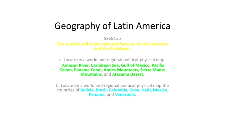
Geography of Latin America SS6G1ab The student will locate selected features of Latin America and the Caribbean. a. Locate on a world and regional political-physical map: Amazon River, Caribbean Sea, Gulf of Mexico, Pacific Ocean, Panama Canal, Andes Mountains, Sierra Madre Mountains, and Atacama Desert. b. Locate on a world and regional political-physical map the countries of Bolivia, Brazil, Colombia, Cuba, Haiti, Mexico, Panama, and Venezuela.
Opening 1/18: 1.) What areas of the world are included in the term Latin America? 2.) Do you think this is a suitable name? Why or Why not? 3.) What would be a better name? or possibility for another name that would make sense? 4.) Describe where in the world Latin America is without using any other country names?
Latin America Includes: Caribbean Mexico Central America South America
Map Song http://www.youtube.com/watch?v=keGRszDVyDk (Sung to the tune of a song from Robin Hood Disney version) Latin America Pacific Ocean, Mexico, Sierra Madre Mountains, the Gulf of Mexico is where the hurricanes blow! Panama has the canal, Colombia, Venezuela, Cuba, Haiti, share the Caribbean Sea. The Atacama desert, Andes Mountains, and Bolivia, the Amazon River runs across northern Brazil. And if you're ever on a boat and floating down the river, you'll go to the Atlantic where the Amazon ends!
ON YOUR MAP Locate & Label the COUNTRIES below and color them lightly in RED/ PIN/ YELLOW colored pencil: ON YOUR MAP Locate & Label the following PHYSICAL FEATURES (draw them on your map with the symbols and colors here): Latin America is located completely within the ________ hemisphere; and its lands spread through the _______ & ______ hemispheres as well. Latin America includes the areas of __________ (directly south of the _____), Central _________ (isthmus), __________ Islands, and __________ America. This area is known for its deep cultural values and traditions. It is also known for being the most diverse area in its physical geography, such as ___________________ _____________________ _____________________ _____________________ _____________________. 11) Equator line (bold black line) 12) Amazon River (trace in dark blue) 13) Caribbean Sea (lightly in blue) 1) Bolivia 14) Gulf of Mexico (lightly in blue) 2) Brazil 15) Pacific Ocean (lightly in blue) 3) Colombia 16) Atlantic Ocean (lightly in blue) 4) Cuba 17) Panama Canal (bold purple line) 5) Haiti 18) Sierra Madre Mtns. (brown 6) Mexico 19)Andes Mtns. (brown 7) Panama 20)Atacama Desert (dark orange) 8) Venezuela 21)Northern Chilean Range (brown 9) Peru 22)Amazon Rainforest (shaded green) 10) Chile
I am the largest country in Latin America. I was colonized by the Portuguese. I am located in eastern South America and west of the Atlantic Ocean.
Brazil Label the area red. See atlas pg. 78 for help.
I am the largest landlocked country in Latin America. I am located west of Brazil and east of the Atacama Desert.
Bolivia Label the area red. See atlas pg. 78 for help.
I am south of the USA, and am the northernmost Latin American Country.
Mexico Label the area red. See atlas pg. 16 for help.
I am the northernmost country in South America. I border the Central American country of Panama.
Colombia Label the area red. See atlas pg. 78 for help.
I am located east of Columbia and south of the Caribbean Sea. The oil industry supports my economy.
Venezuela Label the area red. See atlas pg. 78 for help.
I am an island only 90 miles south of the USA. My country has more of a command economy than any other one we study. I am the largest island in the Caribbean Sea.
Cuba Label the area red. See atlas pg. 16 for help.