Emergency Response SOP for Typhoon Watch and Warning Scenarios
This article outlines the standard operating procedures (SOP) to be followed by relevant agencies in response to typhoon watch and warning scenarios. It includes a flowchart depicting the steps to be taken at different stages of the situation, discussion questions for planning, and specific details on two distinct scenarios - a 72-hour typhoon watch and a 48-hour typhoon warning. The content covers actions, preparations, communication protocols, and critical considerations to ensure effective emergency response and public safety.

Download Presentation

Please find below an Image/Link to download the presentation.
The content on the website is provided AS IS for your information and personal use only. It may not be sold, licensed, or shared on other websites without obtaining consent from the author.If you encounter any issues during the download, it is possible that the publisher has removed the file from their server.
You are allowed to download the files provided on this website for personal or commercial use, subject to the condition that they are used lawfully. All files are the property of their respective owners.
The content on the website is provided AS IS for your information and personal use only. It may not be sold, licensed, or shared on other websites without obtaining consent from the author.
E N D
Presentation Transcript
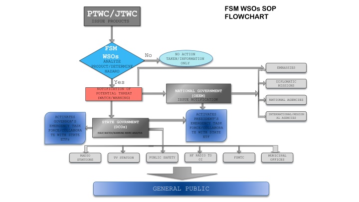
FSM WSOs SOP FLOWCHART PTWC/JTWC ISSUE PRODUCTS FSM WSOs ANALYZE No NO ACTION TAKEN/INFORMATION ONLY PRODUCT/DETERMINE HAZARD EMBASSIES Yes DIPLOMATIC MISSIONS NOTIFICATION OF POTENTIAL THREAT (WATCH/WARNING) NATIONAL GOVERNMENT (OEEM) ISSUE NOTIFICATION NATIONAL AGENCIES ACTIVATES PRESIDENT S EMERGENCY TASK FORCE/COLLABORA TE WITH STATE ETF INTERNATIONAL/REGION AL AGENCIES ACTIVATES GOVERNOR S EMERGENCY TASK FORCE/COLLABORA TE WITH STATE ETFs STATE GOVRNMENT (DCOs) ISSUE WATCH/WARNING MORE ANALYSIS HF RADIO TO OI MUNICIPAL OFFICES RADIO STATIONS PUBLIC SAFETY FSMTC TV STATION GENERAL PUBLIC
Scenario 72 hrs: Typhoon Watch TD 96W Tropical Depression 96W October 24, 2023 7pm Advisory 1 Current Location: just passing South of Majuro heading toward Kosrae Max Sustained Wind 20mph Current Movement 15mph West Advisory 1: A Tropical Depression (96W) has been developed south of Majuro. 96W is slowly developing and moving West including winds of 20mph are possible within 48 72 hrs of Kosrae. At 7pm Kosrae LST .. 96W is currently moving at 15mph. Maximum sustained winds are estimated to be 20mph, intensification is expected in the next 48 to 72 hours. Next advisory will be issued in 12 hours or sooner if there is any sudden changes in forecast.
Discussion Questions: 72 hours 1.Based on your Department s SOP what steps will your agency undertake to respond to the information received? 2. What preparations need to be done?
Scenario 48hrs: Typhoon Warning TS 16W Tropical Storm (16W) October 25, 2023 7am Advisory 2 Current Location: just passing Southeast of Jaluit heading toward Kosrae Max Sustained Wind 37mph Current Movement 15mph West Advisory 2 : Tropical Storm (16W) is now developed around RMI and moving towards the State of Kosrae. Tropical Storm watch is now in effect for the State of Kosrae. 16W is still developing and expected to intensify within the next 12 hours. Please be advised that the forecasted track puts 16W right south of Kosrae within the next 48 hours. Next advisory will be issued in 12 hours or sooner if any changes are made to forecast.
Discussion Questions: 48 hours 1.What information should be communicated to the public at this time? 2. Course of action you think is very critical/important at this point of time but is not listed in your SOP.
Scenario 12hrs: Typhoon Warning TS Sinlaku Tropical Storm Sinlaku October 25, 2023 7pm Advisory 3 Current Location: East of Kosrae Max Sustained Wind 44mph Current Movement 15mph West Northwest Advisory 3: Tropical Storm 16W has now been upgraded to Tropical Storm Sinlaku and a tropical storm WARNING is now in effect for the State of Kosrae. Tropical Storm Sinlaku is now located 150 miles East and continuing its forward movement towards Kosrae. Tropical Storm Sinlaku is expected to make landfall on Kosrae within the next 12-24hrs Maximum sustained winds are still estimated at 44mph. Next immediate update and advisory will be issued in 8 hours or sooner if any changed are made to forecast.
Discussion Questions: 12 hours 1.Landfall is expected within 12 hours. What are the immediate priorities your agency will undertake based on your SOP. 2. If applicable, what are the things that should be done differently.
Scenario update: Hit TS Sinlaku Tropical Storm Sinlaku October 26, 2023 7am Advisory 4 Current Location: 150 miles East of Kosrae Max Sustained Wind 69mph Current Movement 5mph West Northwest Advisory 4: Tropical Storm Sinlaku is rapidly moving West. Tropical Storm Sinlaku is now located10 miles South of Kosrae. Tropical Storm Sinlaku is now moving slowly at 5mph with sustaining winds of 69mph and is expected to get stronger within the next 12 hours. All residents of Kosrae are strongly advised to please remain indoors and in the designated shelters.
TY Sinlaku Typhoon Sinlaku October 26, 2023 7pm Advisory 5 Current Location: 75 miles West of Kosrae Max Sustained Wind 75mph Current Movement 10 mph West Northwest Typhoon Sinlaku is West of Kosrae and SE of Sapwuafik. All residents of Kosrae are encouraged to remain indoors and in safe shelters, strong tropical storm winds are still within our vicinity until notified conditions are updated by Kosrae DCO.
Scenario: ALL CLEAR! Outside the 300mile radius. TY Sinlaku Typhoon Sinlaku October 26, 2023 7pm Advisory 6 Current Location: 300 miles West of Kosrae Max Sustained Wind 85mph Current Movement 10 mph West Northwest All Clear issued from DCO. PRAY for Kosrae!
Discussion Questions: All Clear 1.What resources does your agency have available to respond to the situation and how quickly can they be deployed? 2.Are mutual aid agreements in effect?
New Challenges: DCO It was reported that Lelu and Malem municipalities have a shortage of critical supplies such as food, fuel and water. How will your agency prioritize its resource allocation to ensure that the most critical needs are met first?
New Challenges: Kosrae Utilities Authority The typhoon has caused widespread power outages in the area, affecting several communities. Discuss the necessary steps to be undertaken to ensure that power will be restored the soonest time possible.
New Challenges: FSM Telecom The typhoon has damaged the communication infrastructure resulting in partial / complete loss of phone lines, mobile networks and internet connectivity. Discuss the necessary steps to be undertaken to ensure that communication will be restored the soonest time possible.
New Challenges: Health It was reported that Tafunsak and Utwe are experiencing a diarrhea outbreak, with many residents affected. Discuss ways to manage the health situation.
New Challenges: DCO Due to continuous heavy rain _________ municipality with steep areas experienced landslides, displacing 5 families. Discuss ways for their relocation and recovery assistance.
Wrap up Questions: We hope that this exercise has highlighted the strengths, weaknesses and gaps in your department s SOP on disaster response. Considering the outcomes of this exercise, how can we better prepare for unexpected events in the future?