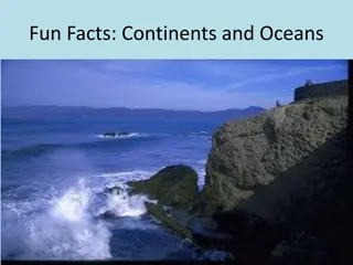
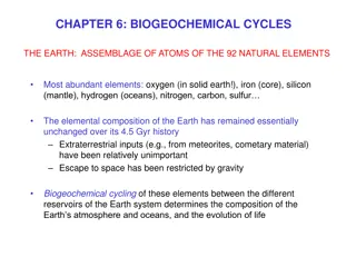
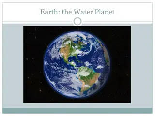
Earth's Oceans: From Formation to Technology


OCEANS
Ch 16 p. 562


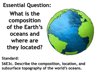
16.1 Earth’s Oceans
All natural waters on Earth are connected. Names are given just to specify
location.
Four main oceans: Pacific (largest & deepest), Atlantic, Indian, Southern/Antarctic
(frozen) & Arctic (frozen; smallest & shallowest)
About 70% Earth is covered by water and 97% of that water is salt water/oceans
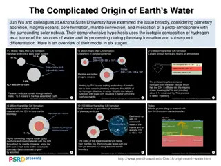
Formation of Oceans
Theories suggest:
Volcanoes on Earth spewed gas & water vapor which condensed in clouds and
later precipitated for years forming oceans
Icy comets & asteroids collided with Earth and melted to form oceans
Tectonic plates cause oceans to change over time. Ocean floor is formed or
disappeared with the volume of the oceans remaining constant
Compostion
Launch Lab p. 563 or 565
Salinity is a measure of the mass of dissolved solids in a mass of water. Ex: Salt
Seawater is from a sea/ocean that has an average salinity of 35 parts per
thousand (ppt).
Where rivers enter the ocean, estuaries are created using brackish water (mix
fresh & salt).
There are several theories as to where the salt came from. See pic graph p. 565
The Seafloor
Continental shelf- shallowest part near the shore
Continental slope-decline of seafloor from shelf to deep water
Continental rise-base of the slope
Abyssal plain-extends across deepest parts of basin (bottom)
Mid-ocean ridge-plates pull apart Trenches- plates push together
Ridges & Trenches
Tallest and longest mountain range is in Atlanta Ocean
Ridge-as seafloor separates, lava erupts from mantle and cools forming new land
Mariana Trench-deepest part of ocean - extends taller than Everest under water -
located in Pacific near Philippines
Technology used to explore the oceans
Manned submersibles-underwater vessel that can withstand extreme pressure
DSV Alvin set a record diving to the bottom of the Mariana Trench
ROVs are unmanned submersibles controlled remotely on a ship-provides more
detailed data & is cheaper & safer - sends video images
Sonar-measuring echo returns similar to dolphins and bats
Seafloor Resources
Two categories:
1)
Energy Resources: oil, natural gas, methane, hydrates are below ocean floor
on continental margins
2)
Minerals: manganese nodules, gold, zinc are located at mid-ocean ridges
Ocean Zones
Surface zone-shallow water that receives the most sunlight and has the most life.
About 650 feet deep
Middle zone-most solar energy has been absorbed, only receives some blue green
light; bottom of this zone is where military subs travel. Over 3000 feet deep
Deep zone-no light or growth; some deep sea animals create their own light using
bioluminescence. Down to 20,000 feet deep
Salinity, temperature, and density vary with depth
16.2 Ocean Wave Parts
All waves have the same basic parts even though there are different kinds & sizes.
Crest-highest part of a wave Trough-lowest part of a wave
Wave height is the vertical distance from trough to crest
Wavelength is the horizontal distance from crest to crest
Pic p. 573
Surface waves
Caused by wind and friction between the wave and seafloor causes a ripple
Range in size but all have same 3 factors: wind speed, time, & distance
Water particles move in a circle and the circle decreases in size with increased
depth See pic p. 574
As the wave moves to shallow water, it changes until it meets the seafloor where
it breaks and surges onto the shore.
Tsunamis
A wave that forms when an ocean disturbance suddenly moves a large
volume/amount of water. It can be caused by earthquake, volcano, landslide, of
glacier breaking.
Some measure close to 100 feet high wave-very dangerous
Ocean Tides
Sea level is the average level of the ocean’s surface at any given time. Tides are
the periodic rise and fall of the ocean’s surface caused by the gravitational force
between Earth, the Moon, and the Sun.
Largest tide pull is between Earth and Moon-producing 2 bulges in ocean
surfaces (high tides). Low tide occurs between these 2 bulges
Size, shape, and depth of oceans affect tides.
Tidal range-difference in water level between high and low tide-varies too
Spring & Neap Tides p. 577
Spring tide is when the tidal range is greatest. It occurs when the Earth, Moon,
and Sun are in a straight line. Gravitational pull from Sun and Moon act together
to make the high tides higher and low tides lower than usual. It is during new and
full moons.
Neap tide is when the tidal range is lowest. It occurs when the Earth, Moon, and
Sun form a right angle. Gravitational pull from Sun and Moon act against one
another to make high tides lower and low tides higher than usual. It is during first
and last quarter moons.
Mini Lab p. 577
16.3 Ocean Currents
Inquiry Discussion p. 580
An ocean current is a large volume/amount of water flowing in a certain direction.
Friction from the wind blowing over an ocean causes
surface currents.
They carry
water horizontally across the surface of the ocean.
Gyres are circles of currents around the globe. Northern hemisphere spins
clockwise Southern hemisphere spins counter clockwise. Differs due to coriolis
effect-movement of wind & water due to Earth’s rotation.
Ocean Currents
The topography (shape) of the land around the ocean affects direction and speed
of currents.
Upwelling currents
are vertical currents created when wind pushes water away
from an area; deep cold water is forced to the surface; brings nutrients to the top
for the aquatic life.
Density currents also are vertical currents that move water down due to density
changes. As water freezes/evaporates, salinity increases causing density to
increase. (Dead Sea) This circulates thermal energy, nutrients, and gases.
How do currents impact climate & weather?
Climate is temperature and moisture of an area for a long period of time-helps
defines seasons. Weather is temperature and moisture of an area daily.
Warm currents like the Gulf Stream produce warm and humid days due to lots of
thermal energy being transferred. Cold currents like the California Current
produce cool and dry days due to less thermal energy being released.
Great Ocean Conveyor Belt
Describes how ocean currents circulate thermal energy around the globe.
Ex: Density currents in N Atlantic and Southern ocean sink and travel on bottom
of the ocean. It goes through Upwelling in the Pacific and Indian ocean and
repeats. Estimated time: 1000 years
If there is a cargo spill in the ocean, the currents move the contents spilled (oil)
which helps scientist study current speed and direction.
Pic p. 585
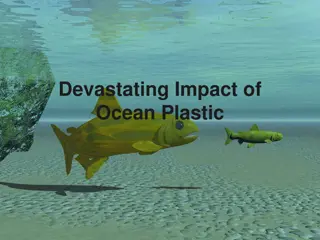
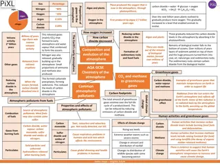
16.4 Environmental Impacts
Pollution is harming the physical, chemical, or biological health of the ocean
ecosystem. Comes from point sources and non-point sources.
Most ocean pollution is caused by humans. Other is comes from the land or air.
Pie graph p. 589 Runoff from land by humans 44%, airborne 33%, spills 10%,
Mining & drilling 1%
Effects of Ocean Pollution
Damages marine life (fish) which kills them or travels to the human food chain.
Solid waste: trash and plastic entangles marine life and birds, not biodegradable
Sediments: land erodes putting sediment which clogs marine life and blocks
sunlight which marine life needs for photosynthesis
Extra Nutrients: marine life depend on healthy algae but extra nutrients causes
harmful algae blooms which kill marine life that eat it; also uses oxygen (O2) in
water killing large amounts of marine life
Effects of Increasing Temp
Coral reefs provide habitats for marine life. One degree temp change causes coral
to begin dieing which is referred to as coral bleaching. Pic p. 592
As glaciers melt the ocean level increases threatening coastal communities and
marine habitats.
Marine life need O2 but the warmer the water, the less oxygen. Global warming?
O2 and CO2 in atmosphere get in seawater making the oceans acidic. This
causes marine life to weaken shells and skeletons. Algae, beginning of ocean food
chain, cannot live in acidic oceans.
Tourism: Whale Watching
Many coastal communities depend on the ocean to help their economy.
Swimming, boating, fishing, scuba diving, whale watching, gas stations,
restaurants, hotels, water parks, amusement parks, etc….. Provide many tax
dollars to coastal communities.
Scientist study upwelling currents to predict where whales could be seen-major
tourist attraction.
What can we do?
Keeping oceans healthy is important for the well-being of humans and other
organisms on Earth.
What can you do to keep the oceans clean?
TEST TIME
Review main ideas p. 598
Study notes from Power Point
Know vocab p. 599
Chapter Review p. 600-601
You got this! Make an A!
Earth's oceans are interconnected bodies of water covering about 70% of the planet. This chapter delves into the formation of oceans, the composition of seawater, the structure of the seafloor, and the technology used to explore the depths. Learn about the theories behind ocean formation, the different ocean basins, salinity levels, and the fascinating ridges and trenches underwater. Discover the advanced tools like manned submersibles, ROVs, and Sonar that aid in ocean exploration and research.

Download Presentation

Please find below an Image/Link to download the presentation.
The content on the website is provided AS IS for your information and personal use only. It may not be sold, licensed, or shared on other websites without obtaining consent from the author.If you encounter any issues during the download, it is possible that the publisher has removed the file from their server.
You are allowed to download the files provided on this website for personal or commercial use, subject to the condition that they are used lawfully. All files are the property of their respective owners.
The content on the website is provided AS IS for your information and personal use only. It may not be sold, licensed, or shared on other websites without obtaining consent from the author.
E N D
Presentation Transcript
OCEANS Ch 16 p. 562
16.1 Earths Oceans All natural waters on Earth are connected. Names are given just to specify location. Four main oceans: Pacific (largest & deepest), Atlantic, Indian, Southern/Antarctic (frozen) & Arctic (frozen; smallest & shallowest) About 70% Earth is covered by water and 97% of that water is salt water/oceans
Formation of Oceans Theories suggest: Volcanoes on Earth spewed gas & water vapor which condensed in clouds and later precipitated for years forming oceans Icy comets & asteroids collided with Earth and melted to form oceans Tectonic plates cause oceans to change over time. Ocean floor is formed or disappeared with the volume of the oceans remaining constant
Compostion Launch Lab p. 563 or 565 Salinity is a measure of the mass of dissolved solids in a mass of water. Ex: Salt Seawater is from a sea/ocean that has an average salinity of 35 parts per thousand (ppt). Where rivers enter the ocean, estuaries are created using brackish water (mix fresh & salt). There are several theories as to where the salt came from. See pic graph p. 565
The Seafloor Continental shelf-shallowest part near the shore Continental slope-decline of seafloor from shelf to deep water Continental rise-base of the slope Abyssal plain-extends across deepest parts of basin (bottom) Mid-ocean ridge-plates pull apart Trenches-plates push together
Ridges & Trenches Tallest and longest mountain range is in Atlanta Ocean Ridge-as seafloor separates, lava erupts from mantle and cools forming new land Mariana Trench-deepest part of ocean -extends taller than Everest under water - located in Pacific near Philippines
Technology used to explore the oceans Manned submersibles-underwater vessel that can withstand extreme pressure DSV Alvin set a record diving to the bottom of the Mariana Trench ROVs are unmanned submersibles controlled remotely on a ship-provides more detailed data & is cheaper & safer -sends video images Sonar-measuring echo returns similar to dolphins and bats
Seafloor Resources Two categories: 1)Energy Resources: oil, natural gas, methane, hydrates are below ocean floor on continental margins 2)Minerals: manganese nodules, gold, zinc are located at mid-ocean ridges
Ocean Zones Surface zone-shallow water that receives the most sunlight and has the most life. About 650 feet deep Middle zone-most solar energy has been absorbed, only receives some blue green light; bottom of this zone is where military subs travel. Over 3000 feet deep Deep zone-no light or growth; some deep sea animals create their own light using bioluminescence. Down to 20,000 feet deep Salinity, temperature, and density vary with depth
16.2 Ocean Wave Parts All waves have the same basic parts even though there are different kinds & sizes. Crest-highest part of a wave Trough-lowest part of a wave Wave height is the vertical distance from trough to crest Wavelength is the horizontal distance from crest to crest Pic p. 573
Surface waves Caused by wind and friction between the wave and seafloor causes a ripple Range in size but all have same 3 factors: wind speed, time, & distance Water particles move in a circle and the circle decreases in size with increased depth See pic p. 574 As the wave moves to shallow water, it changes until it meets the seafloor where it breaks and surges onto the shore.
Tsunamis A wave that forms when an ocean disturbance suddenly moves a large volume/amount of water. It can be caused by earthquake, volcano, landslide, of glacier breaking. Some measure close to 100 feet high wave-very dangerous
Ocean Tides Sea level is the average level of the ocean s surface at any given time. Tides are the periodic rise and fall of the ocean s surface caused by the gravitational force between Earth, the Moon, and the Sun. Largest tide pull is between Earth and Moon-producing 2 bulges in ocean surfaces (high tides). Low tide occurs between these 2 bulges Size, shape, and depth of oceans affect tides. Tidal range-difference in water level between high and low tide-varies too
Spring & Neap Tides p. 577 Spring tide is when the tidal range is greatest. It occurs when the Earth, Moon, and Sun are in a straight line. Gravitational pull from Sun and Moon act together to make the high tides higher and low tides lower than usual. It is during new and full moons. Neap tide is when the tidal range is lowest. It occurs when the Earth, Moon, and Sun form a right angle. Gravitational pull from Sun and Moon act against one another to make high tides lower and low tides higher than usual. It is during first and last quarter moons. Mini Lab p. 577
16.3 Ocean Currents Inquiry Discussion p. 580 An ocean current is a large volume/amount of water flowing in a certain direction. Friction from the wind blowing over an ocean causes surface currents.They carry water horizontally across the surface of the ocean. Gyres are circles of currents around the globe. Northern hemisphere spins clockwise Southern hemisphere spins counter clockwise. Differs due to coriolis effect-movement of wind & water due to Earth s rotation.
Ocean Currents The topography (shape) of the land around the ocean affects direction and speed of currents. Upwelling currents are vertical currents created when wind pushes water away from an area; deep cold water is forced to the surface; brings nutrients to the top for the aquatic life. Density currents also are vertical currents that move water down due to density changes. As water freezes/evaporates, salinity increases causing density to increase. (Dead Sea) This circulates thermal energy, nutrients, and gases.
How do currents impact climate & weather? Climate is temperature and moisture of an area for a long period of time-helps defines seasons. Weather is temperature and moisture of an area daily. Warm currents like the Gulf Stream produce warm and humid days due to lots of thermal energy being transferred. Cold currents like the California Current produce cool and dry days due to less thermal energy being released.
Great Ocean Conveyor Belt Describes how ocean currents circulate thermal energy around the globe. Ex: Density currents in N Atlantic and Southern ocean sink and travel on bottom of the ocean. It goes through Upwelling in the Pacific and Indian ocean and repeats. Estimated time: 1000 years If there is a cargo spill in the ocean, the currents move the contents spilled (oil) which helps scientist study current speed and direction. Pic p. 585
16.4 Environmental Impacts Pollution is harming the physical, chemical, or biological health of the ocean ecosystem. Comes from point sources and non-point sources. Most ocean pollution is caused by humans. Other is comes from the land or air. Pie graph p. 589 Runoff from land by humans 44%, airborne 33%, spills 10%, Mining & drilling 1%
Effects of Ocean Pollution Damages marine life (fish) which kills them or travels to the human food chain. Solid waste: trash and plastic entangles marine life and birds, not biodegradable Sediments: land erodes putting sediment which clogs marine life and blocks sunlight which marine life needs for photosynthesis Extra Nutrients: marine life depend on healthy algae but extra nutrients causes harmful algae blooms which kill marine life that eat it; also uses oxygen (O2) in water killing large amounts of marine life
Effects of Increasing Temp Coral reefs provide habitats for marine life. One degree temp change causes coral to begin dieing which is referred to as coral bleaching. Pic p. 592 As glaciers melt the ocean level increases threatening coastal communities and marine habitats. Marine life need O2 but the warmer the water, the less oxygen. Global warming? O2 and CO2 in atmosphere get in seawater making the oceans acidic. This causes marine life to weaken shells and skeletons. Algae, beginning of ocean food chain, cannot live in acidic oceans.
Tourism: Whale Watching Many coastal communities depend on the ocean to help their economy. Swimming, boating, fishing, scuba diving, whale watching, gas stations, restaurants, hotels, water parks, amusement parks, etc .. Provide many tax dollars to coastal communities. Scientist study upwelling currents to predict where whales could be seen-major tourist attraction.
What can we do? Keeping oceans healthy is important for the well-being of humans and other organisms on Earth. What can you do to keep the oceans clean?
TEST TIME Review main ideas p. 598 Study notes from Power Point Know vocab p. 599 Chapter Review p. 600-601 You got this! Make an A!