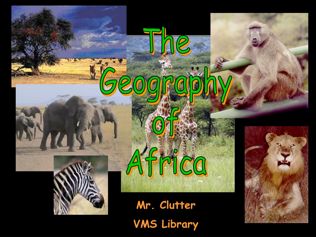
Discovering the Diverse Landscapes of Africa


A Satellite View

Africa’s Size
#
Second largest continent
11,700,000 sq. mi.
#
10% of the world’s population.
#
2 ½ times the size of the U. S.
5
0
0
0
M
I
L
E
S
4
6
0
0
M
I
L
E
S
Bodies
Of
Water
N
i
l
e
R
i
v
e
r
C
o
n
g
o
R
i
v
e
r
Z
a
m
b
e
z
i
R
i
v
e
r
N
i
g
e
r
R
i
v
e
r
O
r
a
n
g
e
R
i
v
e
r
L
i
m
p
o
p
o
R
i
v
e
r
M
e
d
i
t
e
r
r
a
n
e
a
n
S
e
a
A
t
l
a
n
t
i
c
O
c
e
a
n
P
a
c
i
f
i
c
O
c
e
a
n
I
n
d
i
a
n
O
c
e
a
n
R
e
d
S
e
a
L
.
V
i
c
t
o
r
i
a
L
.
A
l
b
e
r
t
-
-
>
L
.
C
h
a
d
-
-
>
L
.
T
a
n
g
a
n
y
i
k
a
-
>
<
-
-
G
u
l
f
o
f
A
d
e
n
The Mighty Nile River:
“Longest River in the World”
The Congo River Basin
#
Covers 12% of the
continent.
#
Extends over 9
countries.
#
2,720 miles long.
#
99% of the country
of Zaire is in the
Congo River basin.
The Niger River Basin
#
Covers 7.5% of the continent.
#
Extends over 10 countries.
#
2,600 miles long.
Hydroelectric Power
D
r
a
j
e
n
s
b
u
r
g
M
t
s
.
R
u
w
e
n
z
o
r
i
M
t
s
.
Δ
M
t
.
K
e
n
y
a
Δ
M
t
.
K
i
l
i
m
a
n
j
a
r
o
Mountains
&
Peaks
A
t
l
a
s
M
t
s
.
The African Plateau
Deserts
S
a
h
a
r
a
D
e
s
e
r
t
S
a
h
e
l
K
a
l
a
h
a
r
i
D
e
s
e
r
t
N
a
m
i
b
D
e
s
e
r
t
L
i
b
y
a
n
D
e
s
e
r
t
The Sahara Desert
Desertification
The Sahel
Valleys
&
Plains
G
r
e
a
t
R
i
f
t
V
a
l
l
e
y
Great Rift Valley
3,000 miles long
Seismic Activity in Africa
Africa:
The
“Tropical”
Continent
T
r
o
p
i
c
o
f
C
a
n
c
e
r
2
0
°
N
T
r
o
p
i
c
o
f
C
a
p
r
i
c
o
r
n
2
0
°
S
E
q
u
a
t
o
r
0
°
African Trade Winds
West Africa:
Home of our Hurricanes
Vegetation Zones
The African Savannah:
13 million sq. mi.
African Rain Forest
#
Annual rainfall of up to 17 ft.
#
Rapid decomposition (very humid).
#
Covers 37 countries.
#
15% of the land surface of Africa.
Mt. Kilimanjaro:
Snow on the Equator
?
The
Complete
Topography
Of
AFRICA
N
i
l
e
R
i
v
e
r
C
o
n
g
o
R
i
v
e
r
Z
a
m
b
e
z
i
R
i
v
e
r
N
i
g
e
r
R
i
v
e
r
O
r
a
n
g
e
R
i
v
e
r
L
i
m
p
o
p
o
R
i
v
e
r
M
e
d
i
t
e
r
r
a
n
e
a
n
S
e
a
A
t
l
a
n
t
i
c
O
c
e
a
n
P
a
c
i
f
i
c
O
c
e
a
n
I
n
d
i
a
n
O
c
e
a
n
R
e
d
S
e
a
L
.
V
i
c
t
o
r
i
a
L
.
A
l
b
e
r
t
-
-
>
L
.
C
h
a
d
-
-
>
L
.
T
a
n
g
a
n
y
i
k
a
-
>
<
-
-
G
u
l
f
o
f
A
d
e
n
D
r
a
j
e
n
s
b
u
r
g
M
t
s
.
R
u
w
e
n
z
o
r
i
M
t
s
.
Δ
M
t
.
K
e
n
y
a
Δ
M
t
.
K
i
l
i
m
a
n
j
a
r
o
S
a
h
a
r
a
D
e
s
e
r
t
S
a
h
e
l
K
a
l
a
h
a
r
i
D
e
s
e
r
t
N
a
m
i
b
D
e
s
e
r
t
L
i
b
y
a
n
D
e
s
e
r
t
G
r
e
a
t
R
i
f
t
V
a
l
l
e
y
A
t
l
a
s
M
t
s
.
T
r
o
p
i
c
o
f
C
a
n
c
e
r
2
0
°
N
T
r
o
p
i
c
o
f
C
a
p
r
i
c
o
r
n
2
0
°
S
E
q
u
a
t
o
r
0
°
Natural Resources
This powerpoint was kindly donated to
www.worldofteaching.com
http://www.worldofteaching.com
is home to over a
thousand powerpoints submitted by teachers. This is a
completely free site and requires no registration. Please
visit and I hope it will help in your teaching.
Embark on a visual journey through Africa's breathtaking geography, from the vast Sahara Desert to the mighty Congo River Basin. Explore the continent's stunning landmarks, including the Nile River, the African Plateau, and the Great Rift Valley. Learn about its diverse ecosystems, water bodies, and iconic mountains like Mt. Kilimanjaro. Witness the beauty and majesty of Africa's natural wonders captured in striking images.

Download Presentation

Please find below an Image/Link to download the presentation.
The content on the website is provided AS IS for your information and personal use only. It may not be sold, licensed, or shared on other websites without obtaining consent from the author.If you encounter any issues during the download, it is possible that the publisher has removed the file from their server.
You are allowed to download the files provided on this website for personal or commercial use, subject to the condition that they are used lawfully. All files are the property of their respective owners.
The content on the website is provided AS IS for your information and personal use only. It may not be sold, licensed, or shared on other websites without obtaining consent from the author.
E N D
Presentation Transcript
The Geography Mr. Clutter VMS Library
Africas Size 4 6 0 0 M I L E S 5 0 0 0 M I L E S # Second largest continent #10% of the world s population. # 2 times the size of the U. S. 11,700,000 sq. mi.
Mediterranean Sea Bodies Of Water NileRiver L. Chad--> L. Albert--> L. Victoria L. Tanganyika-> Indian Ocean Atlantic Ocean Zambezi River LimpopoRiver OrangeRiver Pacific Ocean
The Mighty Nile River: Longest River in the World
The Congo River Basin # Covers 12% of the continent. # Extends over 9 countries. # 2,720 miles long. # 99% of the country of Zaire is in the Congo River basin.
The Niger River Basin # Covers 7.5% of the continent. # Extends over 10 countries. # 2,600 miles long.
Mountains & Peaks Mt. Kenya Mt. Kilimanjaro
Libyan Desert Deserts Sahara Desert Sahel
Valleys & Plains
Great Rift Valley 3,000 miles long
Tropic of Cancer 20 N Africa: The Tropical Continent Equator 0 Tropic of Capricorn 20 S
West Africa: Home of our Hurricanes
The African Savannah: 13 million sq. mi.
African Rain Forest # Annual rainfall of up to 17 ft. # Rapid decomposition (very humid). # Covers 37 countries. # 15% of the land surface of Africa.
Mt. Kilimanjaro: Snow on the Equator?
Mediterranean Sea Libyan Desert The Tropic of Cancer 20 N Sahara Desert Complete Topography Of AFRICA Sahel NileRiver L. Chad--> L. Albert--> Mt. Kenya Equator 0 L. Victoria Mt. Kilimanjaro L. Tanganyika-> Indian Ocean Atlantic Ocean Zambezi River LimpopoRiver Tropic of Capricorn 20 S OrangeRiver Pacific Ocean
This powerpoint was kindly donated to www.worldofteaching.com http://www.worldofteaching.com is home to over a thousand powerpoints submitted by teachers. This is a completely free site and requires no registration. Please visit and I hope it will help in your teaching.