Discover the Geography of Latin America and the Caribbean
Explore the unique features of Latin America and the Caribbean through maps locating key landmarks like the Amazon River, Andes Mountains, and countries including Brazil, Mexico, and Venezuela. Learn about significant locations such as the Atacama Desert and the Panama Canal, along with interesting facts about countries like Cuba and Haiti.

Download Presentation

Please find below an Image/Link to download the presentation.
The content on the website is provided AS IS for your information and personal use only. It may not be sold, licensed, or shared on other websites without obtaining consent from the author. Download presentation by click this link. If you encounter any issues during the download, it is possible that the publisher has removed the file from their server.
E N D
Presentation Transcript
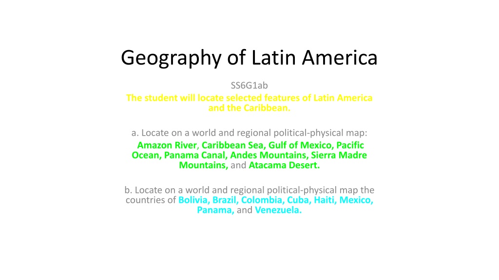
Geography of Latin America SS6G1ab The student will locate selected features of Latin America and the Caribbean. a. Locate on a world and regional political-physical map: Amazon River, Caribbean Sea, Gulf of Mexico, Pacific Ocean, Panama Canal, Andes Mountains, Sierra Madre Mountains, and Atacama Desert. b. Locate on a world and regional political-physical map the countries of Bolivia, Brazil, Colombia, Cuba, Haiti, Mexico, Panama, and Venezuela.
Latin America Includes: Caribbean Mexico Central America South America
Map Song http://www.youtube.com/watch?v=keGRszDVyDk (Sung to the tune of a song from Robin Hood Disney version) Latin America Pacific Ocean, Mexico, Sierra Madre Mountains, the Gulf of Mexico is where the hurricanes blow! Panama has the canal, Colombia, Venezuela, Cuba, Haiti, share the Caribbean Sea. The Atacama desert, Andes Mountains, and Bolivia, the Amazon River runs across northern Brazil. And if you're ever on a boat and floating down the river, you'll go to the Atlantic where the Amazon ends!
Feature Location Significance Amazon River Caribbean Sea Gulf of Mexico Pacific Ocean Panama Canal Andes Mtns. Sierra Madre Mtns. Atacama Desert
Country Location Description Interesting Fact Bolivia Brazil Columbia Cuba Haiti Mexico Panama Venezuela
Atacama Desert Color in yellow or orange. See atlas pg. 79 for help.
Atacama Desert Located between the Pacific Ocean and the Andes Mountains in northern Chile. It is the driest place on earth! (Has never rained in some places!) Largest supply of nitrates on earth. (the sand mummifies/ concrete-like.) = 2nd largest salt flats area in world. http://www.youtube.com/watch?v=uyKKlO50hMA *** http://www.youtube.com/watch?v=WLN5uz42oos
Andes Mountains Color in brown. See atlas pg. 79 for help.
Andes Mountains The longest mountain range in South America. Backbone .2nd driest place on earth. Shields S. Am. From weather. Amazon River begins from glaciers here. Located in the western part of the continent, the mountains extend through the countries of Colombia, Venezuela, Ecuador, Peru, Bolivia, Chile, and Argentina. http://www.youtube.com/watch?v=XePpHMaIAOQ