Temperature Distribution and Differences in Heat
Explore the distribution of temperature across latitudes and elevations, and learn about the difference between heat and temperature. From horizontal to vertical variations, discover how factors like latitude influence temperature distribution patterns globally. Gain insights into the fundamental co
11 views • 19 slides
Sediment Provenance in Geology
Sediment provenance in geology involves reconstructing the origin of sediments through compositional analyses to determine erosion history and geographical origins. It helps characterize the journey of sediments from source to sink, providing insights into tectonic and paleoclimatic histories. Prove
2 views • 11 slides
Differential Leveling in Surveying
Differential leveling is a crucial aspect of surveying that involves determining the elevation of points with respect to a reference datum. This process includes various key elements such as benchmark, back sight, fore sight, and change points. By utilizing methods like the Height of Instrument and
2 views • 12 slides
Bench Marks in Surveying
Bench Marks (B.M) serve as fixed reference points with known elevations, essential for starting any leveling work. They can be categorized into GTS, Permanent, Temporary, and Arbitrary types, each serving specific purposes in surveying projects.
1 views • 8 slides
Louisiana Coastal Flooding Litigation Overview
The content discusses various aspects related to the Katrina Canal breaches consolidated litigation in Louisiana, focusing on the legal implications, failures in flood control measures, geology of coastal Louisiana, coastal elevations, and the impact of canal breaches on flooding in the region. It a
1 views • 30 slides
Multiple Storms Bring Heavy Rainfall and Snowfall to Southern California
Multiple storms impacted Southern California in late December 2019, bringing heavy rainfall and significant snowfall to the region. The two separate systems on December 22-23 and December 25-27 resulted in over 3 inches of total rainfall in some parts of Southern California. The second storm brought
0 views • 8 slides
Heights and Rivers in Nebraska
Discover the diverse elevations across Nebraska, from the soaring peaks of Scottsbluff and Harrison to the river landscapes of Missouri, Republican, and Platte. Explore the varying altitudes of cities like Omaha, Lincoln, and Grand Island, offering unique perspectives from 1,175 to 4,865 feet above
0 views • 34 slides
Building Drawings in Graphic Communication
Building drawings play a crucial role in the construction industry, providing detailed plans for architects, builders, plumbers, electricians, and joiners. These drawings include location plans, floor plans, sectional views, elevations, and schematic diagrams, each serving a specific purpose in the
0 views • 11 slides
The Giant Panda: Ambassador for Endangered Animals
The Giant Panda is a symbol of conservation efforts, with distinctive black and white fur. They primarily eat bamboo and are known for their solitary nature. Despite their bear classification, they do not hibernate and can adapt to various elevations. Learn more about their behavior, diet, and uniqu
1 views • 7 slides
Analysis of Temperature Differences and Inversions at Various Elevations
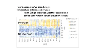
This analysis examines temperature differences and inversions between high-elevation weather stations and lower-elevation stations in a mountainous region. It explores how daytime inversions at lake levels could impact smoke concentrations in the valley, particularly focusing on the effects on air q
0 views • 6 slides
Microclimates and Their Impact on Climate
Microclimates are small areas with distinct climate conditions influenced by factors like landscape, water bodies, and soil. These unique environments can be experienced in urban parks, mountainous regions, and coastal areas. Factors such as high land elevations, proximity to water bodies, and soil
0 views • 20 slides
Non-Temperature Results From CIRS Research Symposium
Rings around Icy Moons are studied through detailed observations and analyses by a team of researchers from various institutions. The study focuses on the IR emissivity results, occultation observations, and beta factor analysis carried out using the CIRS instrument. The rings are noted to emit in a
0 views • 34 slides
Terrain Raw Files in Second Life for Mountain Creation
Delve into the world of terrain.raw files in Second Life to craft a mesh model of a mountain, uncovering insights from forums, tutorials, and helpful tools like Blender and scripts for terrain conversion. Discover techniques to manipulate RGB channels, adjust elevations, and convert files for creati
0 views • 6 slides
Vertical Alignment in Railway Track Geometric Design by Dr. Walied A. Elsaigh
Explore the vertical alignment of railway tracks through Dr. Walied A. Elsaigh's insights on curve length formulas, types of crest and sag vertical curves, properties of typical vertical curves, and a detailed example with solutions for calculating elevations at various stations along the curve. Lea
0 views • 10 slides
Investigating Temperature Variations at Similar Latitudes
In this lesson, students explore why locations at the same latitude can experience different temperature patterns. By analyzing data and considering factors such as proximity to oceans and mountains, students develop an understanding of why latitude alone does not determine temperatures on Earth. Th
0 views • 12 slides
Math Lessons Overview for Year 8 - Summer Term 1 Geometry
Explore the structured math lessons for Year 8 students focusing on 3D geometry. Tasks include drawing shapes, completing multiplications, and understanding plans and elevations. Engage with the content through online resources and practical exercises to enhance mathematical skills.
0 views • 14 slides
