Understanding Distance Indicators and Travel Time Estimation

Map distance indicators

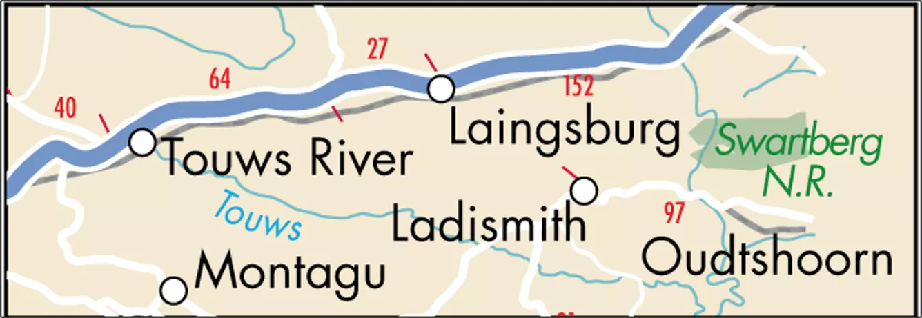
Distance Indicators and distance
•
Some maps use numbers to indicate distances on
the routes that link cities and town.
•
These are known as
distance indicators
may
appear as either
red or black number on the road
shown on the map.
•
These indicators are useful to plan a journey
effectively.
•
Nowadays, Google Maps and other Apps can give
this information instantly on electronic devices.

3 Distance indicators
•
Distance indicators on a map show the
distances between places on the routes
connecting towns.
•
Usually used on tourist maps, then they can
calculate the distances between destinations.
Rules for working out the travel time
•
Travel average 100km/h
•
Travel 200km or 2 hours can be around 10-15
minutes per stop
•
Bad weather, toll gates, stop-and-go can take
extra time
DISTANCE TABLES
•
One of questions tourists most frequently ask is the distance to various
cities and attractions.
•
In order to help them with this information, a
distance table
can be used
to determine distances between destinations.
•
Use the
THREE STEPS
below to determine the distance between two
destinations:
•
Step one:
•
Identify the departure city
•
Step two:
•
Identify the destination city
•
Step three:
•
Read the distance between departure city and the destination city.
Example:
Determine the distance between Johannesburg and Durban
Distance indicators are used on maps to show distances between locations, aiding in journey planning. Travel time estimation rules help calculate journey durations based on average speeds and external factors. Distance tables assist tourists in determining distances between cities. Learn how to use these tools effectively for trip planning.

Download Presentation

Please find below an Image/Link to download the presentation.
The content on the website is provided AS IS for your information and personal use only. It may not be sold, licensed, or shared on other websites without obtaining consent from the author. Download presentation by click this link. If you encounter any issues during the download, it is possible that the publisher has removed the file from their server.
E N D
Presentation Transcript
Distance Indicators and distance Some maps use numbers to indicate distances on the routes that link cities and town. These are known as distance indicators may appear as either red or black number on the road shown on the map. These indicators are useful to plan a journey effectively. Nowadays, Google Maps and other Apps can give this information instantly on electronic devices.
3 Distance indicators Distance indicators on a map show the distances between places on the routes connecting towns. Usually used on tourist maps, then they can calculate the distances between destinations.
Rules for working out the travel time Travel average 100km/h Travel 200km or 2 hours can be around 10-15 minutes per stop Bad weather, toll gates, stop-and-go can take extra time
DISTANCE TABLES One of questions tourists most frequently ask is the distance to various cities and attractions. In order to help them with this information, a distance table can be used to determine distances between destinations. Use the THREE STEPS below to determine the distance between two destinations: Step one: Identify the departure city Step two: Identify the destination city Step three: Read the distance between departure city and the destination city.
Example: Determine the distance between Johannesburg and Durban 2 3 1