Understanding the Hydrological Cycle in Advanced Agro-Hydro-Meteorology
The hydrological cycle involves the continuous movement of water on, above, and below the Earth's surface, encompassing various realms such as the biosphere, atmosphere, cryosphere, lithosphere, and hydrosphere. This cycle describes the storage and movement of water within different Earth systems and is crucial for understanding water distribution and processes like evaporation, transpiration, condensation, and infiltration. Energy exchange between the atmosphere and oceans further influences this cycle, highlighting the interconnectedness of Earth's water systems.

Download Presentation

Please find below an Image/Link to download the presentation.
The content on the website is provided AS IS for your information and personal use only. It may not be sold, licensed, or shared on other websites without obtaining consent from the author. Download presentation by click this link. If you encounter any issues during the download, it is possible that the publisher has removed the file from their server.
E N D
Presentation Transcript
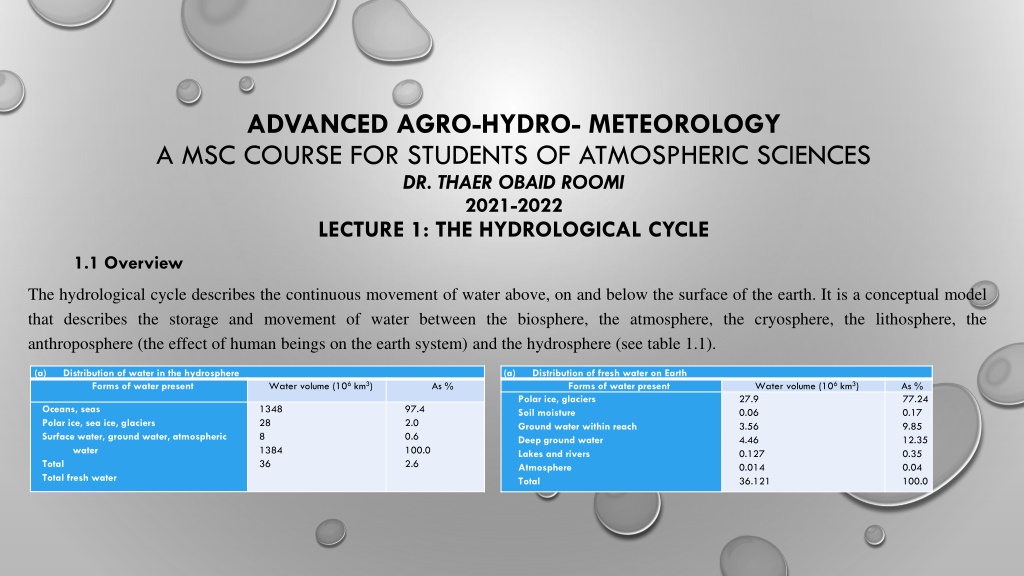
ADVANCED AGRO-HYDRO- METEOROLOGY A MSC COURSE FOR STUDENTS OF ATMOSPHERIC SCIENCES DR. THAER OBAID ROOMI 2021-2022 LECTURE 1: THE HYDROLOGICAL CYCLE 1.1 Overview The hydrological cycle describes the continuous movement of water above, on and below the surface of the earth. It is a conceptual model that describes the storage and movement of water between the biosphere, the atmosphere, the cryosphere, the lithosphere, the anthroposphere (the effect of human beings on the earth system) and the hydrosphere (see table 1.1). (a) Distribution of water in the hydrosphere Forms of water present (a) Distribution of fresh water on Earth Forms of water present Polar ice, glaciers Soil moisture Ground water within reach Deep ground water Lakes and rivers Atmosphere Total Water volume (106 km3) Water volume (106 km3) 27.9 0.06 3.56 4.46 0.127 0.014 36.121 As % As % 77.24 0.17 9.85 12.35 0.35 0.04 100.0 Oceans, seas Polar ice, sea ice, glaciers Surface water, ground water, atmospheric water Total Total fresh water 1348 28 8 1384 36 97.4 2.0 0.6 100.0 2.6
The water on the earths surface: streams, lakes and wetlands in addition to the sea. Surface water also includes the solid forms of precipitation, namely snow and ice. The water below the surface of the earth is ground water. Most of the energy leaves the ocean surface in the form of latent heat in water vapour, but this is not necessarily the case for land surfaces. Hence maritime air masses are different to continental air masses. The atmosphere and oceans are strongly coupled by the exchange of energy, water vapour, momentum at their interface, and precipitation. The oceans represent an enormous reservoir for stored energy and are denser than the atmosphere. The atmosphere is heated from below by the sun s energy intercepted by the underlying surface, whereas the oceans are heated from above.
The hydrological cycle is represented by the simplified diagram in figure 1.1.
1.2 Processes comprising the hydrological cycle There are many processes involved in the hydrological cycle, the most important of which are as follows: Evaporation is the change of state from liquid water to vapour. The energy to achieve this may come from the Sun, the atmosphere itself, the Earth or human activity. Transpiration is the evaporation of water from plants through the small openings found on the underside of leaves (known as stomata). In most plants, transpiration is a passive process largely controlled by the humidity of the atmosphere and the moisture content of the soil. Only 1% of the transpired water passing through a plant is used by the plant to grow, with the rest of the water being passed into the atmosphere.
Condensation is the process whereby water vapour in the atmosphere is changed into liquid water as clouds and dew. This depends upon the air temperature and the dew point temperature. When the air temperature and the dew point temperature are equal, mist and fog occur. Since water vapour has a higher energy level than liquid water, when condensation occurs the excess energy is released in the form of heat. Infiltration of water into the land surface occurs if the ground is not saturated, or contains cracks or fissures. The residence time of water in parts of the hydrological cycle is the average time a water molecule will spend in a particular area. These times are given in Table 1.2. Note that ground water can spend over 10,000 years beneath the surface of the Earth before leaving, whereas water stored in the soil remains there very briefly.
Table 1.2 Average residence times for specific stores Reservoir Average residence time 20,000 years 3,200 years 20 to 100 years 2 to 6 months 1 to 2 months 100 to 200 years 10,000 years 50 to 100 years 2 to 6 months 9 days Antarctica Oceans Glaciers Seasonal snow cover Soil moisture Ground water shallow Ground water deep Lakes Rivers Atmosphere
1.3 Global influences on the hydrological cycle Differential heating by the Sun is the primary cause of the general circulation of the atmosphere. There are a number of regional differences which influence the hydrological cycle in addition to the relative position of the Sun and the Earth. 1. There are latitudinal differences in solar input brought about by the rotation of the Earth. These cause seasonal changes in the circulation patterns, and produce a regular diurnal cycle in the longitude. 2. The fluxes of surface latent and sensible heat are different between continental and oceanic surfaces. 3. Also continental topography varies in ways which significantly impact the atmosphere. 4. Changes in land cover, atmospheric composition and sea surface temperature alter the hydrological cycle both persistently and on a temporary basis. 5. Clouds transport substantial amounts of water around the atmosphere. Consequently they have a major impact on the absorption of solar radiation and modify surface energy balance. Some tall clouds tend to shade and inhibit solar radiation reaching the ground, whereas high clouds inhibit the loss of long wave radiation.
The peak zonal mean precipitable water is situated at 10N for the overall mean (Figure 1.2a) and for the mean over sea (Figure 1.2c). Figure 1.2 Meridional distribution of zonal mean precipitable water (mm): (a) over land and sea, (b) mean over land only, and (c) mean over sea only. Annual mean, December January February (DJF) mean, and June July August (JJA) mean, for 4 years from 1989 to 1992.
1.4 Water balance Water balance at the land surface has generally been estimated using ground observations such as precipitation, water storage in lakes and ground water. This is described by: ?? ??= ??.?? ??.?? ? ? (1.1) where ? represents the water storage within the area, ?? is surface runoff, ?? is the ground water movement, ? is evapotranspiration and ? is precipitation; ?? is horizontal divergence. ? includes snow accumulation in addition to soil moisture, ground water and surface water storage, including retention water. The atmospheric water balance is described by ?? ??+??? = ??.? ??.??+ ? ? (1.2) ?? where ? represents precipitable water in vapour in a column, ?? is the column storage of liquid and solid water, ? is the vertically integrated two dimensional water vapour flux, and ?? is the vertically integrated two dimensional water flux in the liquid and solid phases.
Both the land surface and the atmospheric water balances are summarized in Figure 1.3. Figure 1.3 Illustrating (a) terrestrial water balance, (b) atmospheric water balance and (c) combined atmospheric terrestrial water balance
1.5 Impact of aerosols on the hydrological cycle Aerosol particles (liquid and solid particles, usually other than natural water droplets) are an important part of the water cycle as they serve as condensation nuclei for the formation of cloud droplets as well as scattering and absorbing solar radiation. Atmospheric aerosols range in size from hundredths of a micrometer to many tens of micrometers. They derive from many sources, namely the Earth s surface, oceans, volcanoes and the biosphere. Many aerosols derive from human activity. Large amounts of dust from major deserts, such as the Sahara, produce massive amounts of aerosol. Sea salt produced by bursting air bubbles. Volcanoes can inject large amounts of particles and gases into the atmosphere, and if they reach the stratosphere they are removed more slowly than if they reside only in the troposphere. Increases in aerosols generally greater in size than a few hundredths of a micrometers, referred to as cloud condensation nuclei (CCN), increase the droplet number concentration in clouds, which increases cloud extent and leads to global cooling.
1.6 Coupled models for the hydrological cycle Studies of the hydrological cycle usually involve feedbacks between atmospheric, ecological and hydrological systems, as well as human society. Often the feedbacks between systems produce unanticipated responses. Hence the coupling of different compartments of the Earth system is a challenge to the numerical modelling community. Imposing a boundary between components of the modelled hydro geo biosphere system is not feasible. Observations of two or more state variables that are coupled cannot be modelled simultaneously without the processes that couple them also being included in the model. Over the past two decades advances have been made in interfacing different Earth system components within hydrological models. It is apparent that there is a need for hydrology to interact not only with atmospheric sciences but also with soil sciences, geochemistry, biology and even sociology.
1.7 Global Energy and Water Cycle Exchanges Project (GEWEX) GEWEX is an integrated programme of research, observations and science activities that focuses on the atmospheric, terrestrial, radiative, hydrological, and coupled processes and interactions that determine the global and regional hydrological cycle, radiation and energy transitions and their involvement in climate change. It is the core project in the World Climate Research Programme (WCRP) which is concerned with studying the dynamics and thermodynamics of the atmosphere, its interactions with the Earth s surface, and its effects on the global energy and water cycle. The goal of GEWEX is to reproduce and predict, by means of suitable numerical models, the variations of the global hydrological cycle, its impact on atmospheric and surface dynamics, and variations in regional hydrological processes and water resources and their response to changes in the environment, such as the increase in greenhouse gases.
1.8 Flooding Where land not normally covered by water becomes covered by water, a flood occurs. There are many sources of flooding as follows: River (fluvial) flooding: this occurs when a river cannot cope with the amount of water entering it. Coastal flooding: weather and tidal conditions can increase sea levels. The frequency and severity of this type of flooding are predicted to increase. Surface water (pluvial) flooding: this happens when there is heavy rainfall on ground that is already saturated, or on paved areas where drainage is poor. Ground water flooding: when rainfall causes the water that is naturally stored underground to rise to the surface it can flood low lying areas. Drain and sewer (urban) flooding: this can occur during heavy rain when drains have become blocked or full.


")