Strategies for Fielding a U.S. Winds Mission by 2030
Explore insights from an industry perspective on the strategies needed to launch a U.S. winds mission by 2030, focusing on key goals, investments, and collaborative efforts between public and private sectors. Discover actionable recommendations for agency leaders and the importance of a synergistic science-focused mission.

Download Presentation

Please find below an Image/Link to download the presentation.
The content on the website is provided AS IS for your information and personal use only. It may not be sold, licensed, or shared on other websites without obtaining consent from the author. If you encounter any issues during the download, it is possible that the publisher has removed the file from their server.
You are allowed to download the files provided on this website for personal or commercial use, subject to the condition that they are used lawfully. All files are the property of their respective owners.
The content on the website is provided AS IS for your information and personal use only. It may not be sold, licensed, or shared on other websites without obtaining consent from the author.
E N D
Presentation Transcript
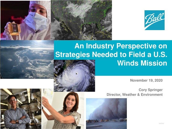
An Industry Perspective on Strategies Needed to Field a U.S. Winds Mission November 19, 2020 Cory Springer Director, Weather & Environment 4/4/2025
BLUF (Bottom Line Up Front) NOAA stated goal, via the NSOSA, is to field an operational 3D winds mission by 2030 (a high priority ); AEOLUS has demonstrated that the impact of a wind lidar system is profound; Through significant NASA and private sector technology investments, the U.S. is ready to go to space; Such a system will not require a $1B investment; The private sector should be part of the solution; This WG can play a leading role in fielding a space- based U.S. wind lidar system by 2030
Agenda Observations & Assessment What can be done Where to start Recommendations
Observations & Assessment A more focused, common WG goal could be valuable to the agencies as they develop programs and budgets; There seems to be a subconscious, self-inflicted constraint within the WG that any U.S. wind lidar system must meet both operational WX and NASA science (PBL, small-scale processes) needs; One possible near-term goal: provide technical and programmatic recommendations for fielding an operational U.S. wind lidar mission by 2030; Developing an operational wind lidar mission will be a team sport between public and private sectors;
What Can Be Done Provide actionable recommendations to agency leaders to support programmatic planning activities; Initial priority: come to a consensus on technical approach recommend focus on a system or set of systems that can be fielded by 2030 to meet NOAA s operational requirements; Leverage investments made to date and provide recommendations for future agency investments supporting a 2030 mission; Follow-on priority: recommend technical approach for a synergistic/complimentary science-focused mission for a future NASA Explorer mission to support NASA Atmospheric Winds/PBL science needs;
Where to Start We are in a great place! What do we know? 1) Technology is mature/ready to go to space (AEOLUS, OAWL); 2) It s not a $1B mission (AEOLUS, ATHENA OAWL); 3) It builds on previous work (CALIPSO, AEOLUS, OAWLs, DLR Falcon lidars, DAWN); We know the technology is ready to go to space thanks ESA for leading the way! Ball s space-based OAWL design continues to advance and has been deemed acceptable risk & selectable by NASA Technical, Management, Cost, and Other (TMCO); CALIPSO is still operating after 14 years and > 8 billion lasers shots!
Recommendations for WG Come to consensus on a common goal; Near-term priority should be supporting NOAA since they are in the middle of defining their nextgen architecture; Develop a roadmap to a 2030 operational system launch; Recommend technical solution (optimized for performance and cost) to provide maximum bang-for-the- buck; Solution should recognize complimentary contributions of partner nations, passive AMVs and airborne obs how would one design a combined wind lidar, passive IR sounder mission, augmented by and airborne obs? Solution should also recognize boundary conditions (i.e., budgetary realism - thus NOAA s desire for smallsat solutions - 2030 on-orbit goal, etc.);
Questions / Comments or better yet, group discussion

")


![[PDF⚡READ❤ONLINE] Black Hole Astrophysics: The Engine Paradigm (Springer Praxis](/thumb/21503/pdf-read-online-black-hole-astrophysics-the-engine-paradigm-springer-praxis.jpg)
![❤[PDF]⚡ Planetary Ring Systems (Springer Praxis Books)](/thumb/21506/pdf-planetary-ring-systems-springer-praxis-books.jpg)
![READ⚡[PDF]✔ The Earth in Context: A Guide to the Solar System (Springer-Praxis S](/thumb/21508/read-pdf-the-earth-in-context-a-guide-to-the-solar-system-springer-praxis-s.jpg)
![❤[READ]❤ Deep Space Craft: An Overview of Interplanetary Flight (Springer Praxis](/thumb/21511/read-deep-space-craft-an-overview-of-interplanetary-flight-springer-praxis.jpg)
![get⚡[PDF]❤ The Hubble Space Telescope: From Concept to Success (Springer Praxis](/thumb/21514/get-pdf-the-hubble-space-telescope-from-concept-to-success-springer-praxis.jpg)
![❤Book⚡[PDF]✔ Spaceplane HERMES: Europe's Dream of Independent Manned Spaceflight](/thumb/21517/book-pdf-spaceplane-hermes-europe-s-dream-of-independent-manned-spaceflight.jpg)
![Read⚡ebook✔[PDF] Linking the Space Shuttle and Space Stations: Early Docking Te](/thumb/21519/read-ebook-pdf-linking-the-space-shuttle-and-space-stations-early-docking-te.jpg)

![[PDF⚡READ❤ONLINE] Solar Surveyors: Observing the Sun from Space (Springer Praxis](/thumb/21536/pdf-read-online-solar-surveyors-observing-the-sun-from-space-springer-praxis.jpg)

![[PDF⚡READ❤ONLINE] Planet Mercury: From Pale Pink Dot to Dynamic World (Springer](/thumb/21549/pdf-read-online-planet-mercury-from-pale-pink-dot-to-dynamic-world-springer.jpg)
![❤[PDF]⚡ Apollo Mission Control: The Making of a National Historic Landmark (Spr](/thumb/21551/pdf-apollo-mission-control-the-making-of-a-national-historic-landmark-spr.jpg)
![READ⚡[PDF]✔ Emerging Space Powers: The New Space Programs of Asia, the Middle Ea](/thumb/21554/read-pdf-emerging-space-powers-the-new-space-programs-of-asia-the-middle-ea.jpg)
![❤[READ]❤ Cosmic Biology: How Life Could Evolve on Other Worlds (Springer Praxis](/thumb/21556/read-cosmic-biology-how-life-could-evolve-on-other-worlds-springer-praxis.jpg)
![❤[PDF]⚡ Space Exploration 2007 (Springer Praxis Books)](/thumb/21607/pdf-space-exploration-2007-springer-praxis-books.jpg)
![READ⚡[PDF]✔ Space Exploration 2008 (Springer Praxis Books)](/thumb/21608/read-pdf-space-exploration-2008-springer-praxis-books.jpg)
![get⚡[PDF]❤ Space 2.0 (Springer Praxis Books)](/thumb/21609/get-pdf-space-2-0-springer-praxis-books.jpg)