Soil and Water Conservation Techniques in Rainfed Agriculture by Mr. Anil Swami
Explore soil erosion and various conservation techniques discussed by Mr. Anil Swami, an Assistant Professor specializing in Rainfed Agriculture and Watershed Management. Learn about prevalent soil and climatic conditions in rainfed areas, water harvesting techniques, contingent crop planning, seasonal rainfall patterns, types of erosion, and more to combat soil loss in agricultural practices.

Download Presentation

Please find below an Image/Link to download the presentation.
The content on the website is provided AS IS for your information and personal use only. It may not be sold, licensed, or shared on other websites without obtaining consent from the author.If you encounter any issues during the download, it is possible that the publisher has removed the file from their server.
You are allowed to download the files provided on this website for personal or commercial use, subject to the condition that they are used lawfully. All files are the property of their respective owners.
The content on the website is provided AS IS for your information and personal use only. It may not be sold, licensed, or shared on other websites without obtaining consent from the author.
E N D
Presentation Transcript
SOIL AND WATER CONSERVATION TECHNIQUES Delivered by Mr. ANIL SWAMI Asst. Professor 1 Mr. ANIL SWAMI Mr. ANIL SWAMI Rainfed Agriculture & Watershed Management Rainfed Agriculture & Watershed Management
Objective:- Tell the soil and climatic conditions prevalent in rainfed areas. Interpret various water harvesting techniques and their efficient utilization. Apply contingent crop planning for aberrant weather conditions. Examine the seasonal rainfall and different types of watershed and its components. Select soil and water conservation techniques to avoid their losses. 2 Mr. ANIL SWAMI Rainfed Agriculture & Watershed Management
Soil Erosion: Soil and Water Conservation Techniques Soil erosion: Soil erosion is the process of detachment of soil particles from the top soil and transportation of the detached soil particles by wind and / or water. The agents causing erosion are wind and water. The detaching agents are falling raindrop, channel flow and wind. The transporting agents are flowing water, rain splash and wind. 3 Mr. ANIL SWAMI Rainfed Agriculture & Watershed Management
Nature and extent of erosion The problem of soil erosion exists all over the country. Out of the 329 m. ha of India s geographical area about 175 m. ha (53.3%) is subjected to soil erosion and some kind of land degradation. About 150 m. ha is subjected to wind and water erosion. It is estimated that about 5333 Mt of soil is detached annually. Out of this 29 % is carried away by rivers to seas and about 10% is deposited in reservoirs resulting in 1-2 % of loss of storage capacity annually. The estimated annual soil loss is 16.35 tones /ha/year. 4 Mr. ANIL SWAMI Rainfed Agriculture & Watershed Management
5 Mr. ANIL SWAMI Rainfed Agriculture & Watershed Management
Types of erosion: There are two major types of soil erosion a) Geological erosion (Natural or normal erosion): is said to be in equilibrium with soil forming process. It takes place under natural vegetative cover completely undisturbed by biotic factors. This is very slow process. b) Accelerated erosion: is due to disturbance in natural equilibrium by the activities of man and animals through land mismanagement, destructing of forests over grazing etc., Soil loss through erosion is more than the soil formed due to soil forming process. 6 Mr. ANIL SWAMI Rainfed Agriculture & Watershed Management
Based on the agents causing erosion, erosion is divided into a. Water erosion b. Wind erosion c. Wave erosion 7 Mr. ANIL SWAMI Rainfed Agriculture & Watershed Management
A.Water erosion Loss of soil from land surface by water including run off from melted snow and ice is usually referred to as water erosion. Major erosive agents in water erosion are impacting/ falling raindrops and runoff water flowing over soil surface. Process of water erosion Detachment of soil particles is by either raindrop impact or flowing water. Individual raindrops strike the soil surface at velocities up to 9 m/s creating very intensive hydrodynamic force at the point of impact leading to soil particle detachment. 8 Mr. ANIL SWAMI Rainfed Agriculture & Watershed Management
Over land flow detaches soil particles when their erosive hydrodynamic force exceeds the resistance of soil to erosion. Detached soil particles are transported by raindrop splash and runoff. The amount of soil transported by runoff is more than due to raindrop splash. Thus the falling raindrops break the soil aggregates and detach soil particles from each other. The finer particles (silt and clay) block the soil pores and increase the rate of runoff and hence loss of water and soil. 9 Mr. ANIL SWAMI Rainfed Agriculture & Watershed Management
Forms/Types of water erosion Water erosion occurs in stages identified as sheet erosion, rills, gullies, ravines, landslides and stream bank erosion. a) Sheet erosion: It is the uniform removal of surface soil in thin layers by rainfall and runoff water. The breaking action of raindrop combined with surface flow is the major cause of sheet erosion. It is the first stage of erosion and is least conspicuous, but the most extensive. 10 Mr. ANIL SWAMI Rainfed Agriculture & Watershed Management
B . Rill erosion: When runoff starts, channelization begins and erosion is no longer uniform. Raindrop impact does not directly detach any particles below flow line in rills but increases the detachment and transportation capacity of the flow. Rill erosion starts when the runoff exceeds 0.3 to 0.7 mm/s. Incisions are formed on the ground due to runoff and erosion is more apparent than sheet erosion. This is the second stage of erosion. Rills are small channels, which can be removed by timely normal tillage operations. 11 Mr. ANIL SWAMI Rainfed Agriculture & Watershed Management
c. Gully erosion: It is the advanced stage of water erosion. Size of the unchecked rills increases due to runoff. Gullies are formed when channelized runoff form vast sloping land is sufficient in volume and velocity to cut deep and wide channels. Gullies are the spectacular symptoms of erosion. If unchecked in time no scope for arable crop production. 12 Mr. ANIL SWAMI Rainfed Agriculture & Watershed Management
d. Ravines: They are the manifestations of a prolonged process of gully erosion. They are typically found in deep alluvial soils. They are deep and wide gullies indicating advanced stage of gully erosion. e. Landslides: Landslides occur in mountain slopes, when the slope exceeds 20% and width is 6 m. Generally, landslides cause blockage of traffic in ghat roads. 13 Mr. ANIL SWAMI Rainfed Agriculture & Watershed Management
f. Stream bank erosion: Small streams, rivulets, torrents (hill streams) are subjected to stream bank erosion due to obstruction of their flow. Vegetation sprouts when streams dry up and obstructs the flow causing cutting of bank or changing of flow course. 14 Mr. ANIL SWAMI Rainfed Agriculture & Watershed Management
Factors affecting water erosion a)Climate: Water erosion is directly a function of rainfall and runoff. Amount, duration and distribution of rainfall influences runoff and erosion. High intensity rains of longer duration causes severe erosion. Greater the intensity, larger the size of the raindrop. Rainfall intensity more than 5 cm/hr is considered as severe. 15 Mr. ANIL SWAMI Rainfed Agriculture & Watershed Management
Total energy of raindrops falling over a hectare land with rainfall intensity of 5 cm /hr is equal to 625 H.P. This energy can lift 89 times the surface 17.5 cm of soil from one ha to a height of 3 ft. Two- thirds of the above energy is used for sealing soil pores. Runoff may occur without erosion but there is no water erosion without runoff. The raindrop thus breaks down soil aggregates, detaches soil particles and leads the rainwater with the fine particles. These fine particles seal the pores of the surface soil and increases runoff causing erosion. 16 Mr. ANIL SWAMI Rainfed Agriculture & Watershed Management
b. Topography: The degree, length and curvature of slope determine the amount of runoff and extent of erosion. Water flows slowly over a gentle slope where as at a faster rate over a steeper one. As water flows down the slope, it accelerates under the forces of gravity. When runoff attains a velocity of about 1 m/s it is capable of eroding the soil. If the percent of slope is increased by 4 times the velocity of water flowing down is doubled. Doubling the velocity quadruples the erosive power and increases the quantity of soil that can be transported by about 32 times and size of the particles that can be transported by about 64 times. 17 Mr. ANIL SWAMI Rainfed Agriculture & Watershed Management
c. Vegetation: Vegetation intercepts the rainfall and reduces the impact of raindrops. It also decreases the velocity of runoff by obstructing the flow of water. The fibrous roots are also effective in forming stable soil aggregates, which increases infiltration and reduces erosion. 18 Mr. ANIL SWAMI Rainfed Agriculture & Watershed Management
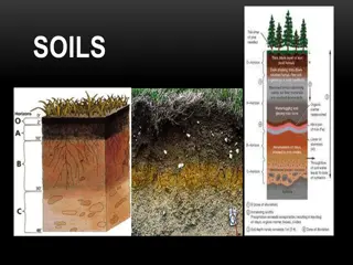
d. Soil Properties: Soil properties that influence soil erodibility by water may be grouped into two types. i. Those properties that influence the infiltration rate and permeability ii. Those properties that resist the dispersion, splashing, abrasion and transporting forces of rainfall and runoff. The structure, texture, organic matter and moisture content of upper layers determine the extent of erosion. Sandy soils are readily detachable but not readily transportable. Soils of medium to high clay content have low infiltration capacities and they are readily transported by water after they are dispersed, but their detachability is generally low. 19 Mr. ANIL SWAMI Rainfed Agriculture & Watershed Management
e. Man and beast Man and beast accelerates erosion by extensive farming and excessive grazing. Faulty practices like cultivation on steep slopes, cultivation up and down the slope, felling and burning of forests etc., leads to heavy erosion. Excessive grazing destroys all vegetation and increases the erosion 20 Mr. ANIL SWAMI Rainfed Agriculture & Watershed Management
Estimation of soil loss by water erosion Based on the mechanism and factors influencing soil erosion, a universal soil loss equation (USLE) developed by Wischmeier (1959) is most useful for predicting soil loss due to water erosion. It is an empirical equation and estimates average annual soil loss per unit area as a function of major factors affecting sheet and rill erosion. It enables determination of land management erosion rate relationships for a wide range of rainfall, soil slope and crop and management conditions and to select alternative cropping and management combinations that limit erosion rates to acceptable limits. 21 Mr. ANIL SWAMI Rainfed Agriculture & Watershed Management
? = ? ? ? ? ? ? ? ? ? ? ? where, A= predicted soil loss in t/ha/year R= rainfall erosivity factor or index K= soil erodibility factor L= length of slope factor S= slope steepness factor C= soil cover and management factor and P= erosion control factor 22 Mr. ANIL SWAMI Rainfed Agriculture & Watershed Management
B. Wind erosion Erosion of soil by the action of wind is known as wind erosion. It is a serious problem on lands devoid of vegetation. It is more common in arid and semi-arid regions. It is essentially a dry weather phenomenon stimulated by the soil moisture deficiency. The process of wind erosion consists of three phases: a. initiation of movement b. transportation and c. deposition. About 33 m.ha in India is affected by wind erosion. This includes 23.49 m.ha of desert and about 6.5 m.ha of coastal sands. The Thar Desert is formed mainly by blow in sand. 23 Mr. ANIL SWAMI Rainfed Agriculture & Watershed Management
Mechanism of wind erosion Lifting and abrasive action of wind results in detachment of tiny soil particles from the granules or clods. The impact of these rapidly moving particles dislodge other particles from clods and aggregates. These dislodged particles are ready for movement. Movement of soil particles in wind erosion is initiated when the pressure by the wind against the surface soil grains overcomes the force of gravity on the grains. 24 Mr. ANIL SWAMI Rainfed Agriculture & Watershed Management
Minimum wind velocity necessary for initiating the movement of most erodable soil particles (about 0.1 mm diameter) is about 16 km /hr at a height of 30.5 cm. Most practical limit under field conditions, where a mixture of sizes of single grained material present is about 21 km/hr at a height of 30.5 cm. In general movement of soil particles by wind takes place in three stages: saltation, surface creep and suspension. 25 Mr. ANIL SWAMI Rainfed Agriculture & Watershed Management
a. Saltation: It is the first stage of movement of soil particles in a short series of bounces or jumps along the ground surface. After being rolled by the wind, soil particles suddenly leap almost vertically to form the initial stage of movement in saltation. The size of soil particles moved by saltation is between 0.1 to 0.5 mm in diameter. This process may account for 50 to 70% of the total movement by wind erosion 26 Mr. ANIL SWAMI Rainfed Agriculture & Watershed Management
b. Surface creep: Rolling and sliding of soil particles along the ground surface due to impact of particles descending and hitting during saltation is called surface creep. Movement of particles by surface creep causes an abrasive action of soil surface leading to break down of non-erodable soil aggregates. Coarse particles longer than 0.5 to 2.0 mm diameter are moved by surface creep. This process may account for 5 to 25% of the total movement. 27 Mr. ANIL SWAMI Rainfed Agriculture & Watershed Management
c. Suspension: Movement of fine dust particles smaller than 0.1 mm diameter by floating in the air is known as suspension. Soil particles carried in suspension are deposited when the sedimentation force is greater than the force holding the particles in suspension. This occurs with decrease in wind velocity. Suspension usually may not account for more than 15% of total movement. 28 Mr. ANIL SWAMI Rainfed Agriculture & Watershed Management
Soil & Water Conservation Techniques Definition of soil conservation Soil conservation is using and managing the land based on the capabilities of the land itself involving application of the best management practices leading to profitable crop production without land degradation. 29 Mr. ANIL SWAMI Rainfed Agriculture & Watershed Management
Control of water erosion Water erosion occurs simultaneously in two steps: detachment of soil particles by falling raindrops and transportation of detached particles by flowing water. Hence preventing the detachment of soil particles and their transportation can minimize water erosion. 30 Mr. ANIL SWAMI Rainfed Agriculture & Watershed Management
Principles of water erosion control are. Maintenance of soil infiltration capacity Soil protection from rainfall Control of surface runoff and Safe disposal of surface runoff For a sound soil conservation program every piece of land must be used in accordance with the land capability classification. 31 Mr. ANIL SWAMI Rainfed Agriculture & Watershed Management
Measures of water erosion control 1. Agronomic measures 2. Mechanical measures (Engineering measures) 3. Agrostological measures 32 Mr. ANIL SWAMI Rainfed Agriculture & Watershed Management
AGRONOMIC MEASURES OF SOIL CONSERVATION In soil and water conservation programs agronomic measures have to be considered in co-ordination with others for their effectiveness. These measures are effective in low rainfall areas particularly in fairly erosion resistant soils having gentle slope (< 2 %). 33 Mr. ANIL SWAMI Rainfed Agriculture & Watershed Management
The different agronomic measures include e)Crop rotation / cropping systems a)Land preparation f)Cover crops b)Contour cultivation g)Mulching c)Choice of crops h)Application of manures and fertilizers d)Strip cropping i) Application of chemicals 34 Mr. ANIL SWAMI Rainfed Agriculture & Watershed Management
Land preparation: Land preparation including post-harvest tillage influence intake of water, obstruction to surface flow and consequently the rate of erosion. Deep ploughing or chiseling has been found effective in reducing erosion. Rough cloddy surface is also effective in reducing erosion. 35 Mr. ANIL SWAMI Rainfed Agriculture & Watershed Management
Contour cultivation (Contour farming): A line joining the points of equal elevation is called contour. All the cultural practices such as ploughing, sowing, inter-cultivation etc. done across the slope reduce soil and water loss. By ploughing and sowing across the slope, each ridge of plough furrow and each row of the crop act as obstruction to the runoff and provide more time for water to enter into the soil leading to reduced soil and water loss. 36 Mr. ANIL SWAMI Rainfed Agriculture & Watershed Management
Choice of crops: Row crops or tall growing crops such as sorghum, maize, pearl millet etc. are not effective in conserving soil as they expose majority of the soil and hence they are known as erosion permitting crops. Whereas close growing crops such as cowpea, groundnut, green gram, black gram etc., which protect soil are known as erosion resisting crops as they are very effective in reducing soil loss by minimizing the impact of rain drop and acting as obstruction to runoff. 37 Mr. ANIL SWAMI Rainfed Agriculture & Watershed Management
Strip cropping: It is a system of growing of few rows of erosion resisting crops and erosion permitting crops in alternate strips on contour (across the slope) with the objective of breaking long slopes to prevent soil loss and runoff. Close growing erosion resisting crops reduce the transporting and eroding power of water by obstructing runoff and filtering sediment from runoff to retain in the field. The width of the erosion permitting and erosion resisting crops vary as per the slope of the field. The strip cropping resembles the intercropping. 38 Mr. ANIL SWAMI Rainfed Agriculture & Watershed Management
With increase in per cent slope of the soil, the width of erosion permitting and erosion resisting crops decreases. The normal ratio between the erosion resisting crops and erosion permitting crops is 1: 3. 39 Mr. ANIL SWAMI Rainfed Agriculture & Watershed Management
The strip cropping is divided into four types as follows i) Contour strip cropping: The erosion permitting crops and erosion resisting crops are grown in alternate strips along the contours. ii) Field strip cropping: Alternate strips of erosion permitting crops and erosion resisting crops are raised across the general slope not necessarily on exact contour iii)Wind strip cropping: Strip cropping of erosion permitting and erosion resisting crops across the direction of the most prevailing wind irrespective of the contour. iv)Buffer strip cropping: this type of strip cropping is practiced in areas having steep slopes and badly eroded soils where strips of permanent cover crops or perennial legumes or grasses or shrubs are alternated with field crops. The strip cropping is simple, cheap and effective soil conservation practice and can be adopted by the farmers. 40 Mr. ANIL SWAMI Rainfed Agriculture & Watershed Management
Crop rotation / cropping system: Mono-cropping of erosion permitting crops accelerates soil and water loss year after year. Intercropping of erosion permitting crops and erosion resisting crops or their rotation has been found effective for reducing soil and water loss. Inclusion of legumes like lucerne in crop rotation reduces soil loss even in soils having 13% slopes. 41 Mr. ANIL SWAMI Rainfed Agriculture & Watershed Management
Cover crops: Good grounds cover by canopy gives the protection to the land like an umbrella and minimize soil erosion. Besides conserving soil and moisture, the cover crops hold those soluble nutrients, which are lost by leaching. The third advantage of the cover crops is the addition of organic matter. The legumes provide better cover and better protection. Among the legumes cowpea has been found to produce maximum canopy followed by horsegram, green gram, black gram and dhaincha. 42 Mr. ANIL SWAMI Rainfed Agriculture & Watershed Management
Mulching: Mulching of soil with available plant residues reduce soil loss considerably by protecting the soil from direct impact of raindrop and reducing the sediment carried with runoff. A minimum plant residue cover of 30 per cent is necessary to keep runoff and soil loss within the acceptable limits. Vertical mulching also reduce soil loss particularly in vertisols by increasing infiltration. 43 Mr. ANIL SWAMI Rainfed Agriculture & Watershed Management
Application of manures and fertilizers : Organic manures besides supplying nutrients improve soil physical conditions thereby reduce soil loss. Fertilizers improve vegetative canopy, which aid in erosion control. 44 Mr. ANIL SWAMI Rainfed Agriculture & Watershed Management
Use of chemicals: Breakdown of aggregates by the falling raindrops is the main cause of detachment of soil particles. Soils with stable aggregates resist breakdown and thus resist erosion. Aggregate stability can be increased by spraying chemicals like poly vinyl alcohol @ 480 kg/ha (rate will depend on the type of soil). Soils treated with bitumen increase water stable aggregates and infiltration capacity of the soil. 45 Mr. ANIL SWAMI Rainfed Agriculture & Watershed Management
MECHANICAL MEASURES (ENGINEERING MEASURES) The basic principle are: (i)shaping the land surface manually or with implements in such a way as to reduce the velocity of runoff, (ii)to allow more time for rainfall to stand on soil surface, and (iii)to facilitate more infiltration of rainfall into soil layers. 46 Mr. ANIL SWAMI Rainfed Agriculture & Watershed Management
Choice of any particular method under a given situation is influenced by rainfall characters, soil type, crops, sowing methods and slope of land. (i)Basin listing: Formation of small depressions (basins) of 10 15 cm depth and 10 15 cm width at regular intervals using an implement called basin lister. The small basins collect rainfall and improve its storage. It is usually done before sowing. It is suitable for all soil types and crops. 47 Mr. ANIL SWAMI Rainfed Agriculture & Watershed Management
Basin Lister 48 Mr. ANIL SWAMI Rainfed Agriculture & Watershed Management
Bunding: Formation of narrow based or broad-based bunds across slope at suitable intervals depending on slope of field. The bunds check the free flow of runoff water, impound the rainwater in the inter-bund space, increase its infiltration and improve soil moisture storage. Leveling of inter-bund space is essential to ensure uniform spread of water and avoid water stagnation in patches. It can be classified into three types: 49 Mr. ANIL SWAMI Rainfed Agriculture & Watershed Management
(a) Contour bunding: Bunds of 1 m basal width, 0.5 m top width and 0.5 m height are formed along the contour. The distance between two contour bunds depends on slope. The inter-bund surface is leveled and used for cropping. It is suitable for deep red soils with slope less than 1%. It is not suitable for heavy black soils with low infiltration where bunds tend to develop cracks on drying. Contour bunds are permanent structures and require technical assistance and heavy investment. 50 Mr. ANIL SWAMI Rainfed Agriculture & Watershed Management


:")


 Contour bunding:")