Exploring the Rich Ecosystem of Equatorial Forests

The Equatorial Forests are a vital region between the Tropics of Cancer and Capricorn, abundant in dense vegetation, diverse wildlife including gorillas and elephants, and a unique climate characterized by hot temperatures and convectional rainfall. This biodiverse area is also rich in economic resources such as farming, forestry, and fishing, making it a significant region with a fascinating landscape and resourceful inhabitants.

Download Presentation

Please find below an Image/Link to download the presentation.
The content on the website is provided AS IS for your information and personal use only. It may not be sold, licensed, or shared on other websites without obtaining consent from the author.If you encounter any issues during the download, it is possible that the publisher has removed the file from their server.
You are allowed to download the files provided on this website for personal or commercial use, subject to the condition that they are used lawfully. All files are the property of their respective owners.
The content on the website is provided AS IS for your information and personal use only. It may not be sold, licensed, or shared on other websites without obtaining consent from the author.
E N D
Presentation Transcript
6.THE LAND OF DENSE FORESTS CONTENTS: 1.LOCATION /LAND 2. CLIMATE 3.VEGETATION PLANT LIFE ANIMAL LIFE 4.ECONOMIC RESOURCES 5.LIFE OF THE PEOPLE 6.TRANSPORT 2 7.CITIES
LOCATION/LAND THE REGION BETWEEN TROPIC OF CANCER AND THE TROPIC OF CAPRICORN IS EQUATORIAL REGION 4
LOCATION OF DRC THE DRC IS THE SECOND LARGEST IN AFRICA. THE EQUATOR PASSES THROUGH THE NORTHERN PART OF THE COUNTRY. THE COUNTRY IS LOCATED IN CENTRAL AFRICA. IT IS SURROUNDED BY NINE COUNTRIES. 5 CHAPTER 6/KARUNAMBIGAI/SOCIAL DEPT/SNS ACADEMY
Land RIVER CONGO IS THE SECOND LONGEST RIVER IN AFRICA. IT IS KNOWN AS THE HIGHWAY OF CENTRAL AFRICA. IT IS SURROUNDED BY MOUNTAINS AND PLATEAUS. RUWENZORI MOUNTAIN IN THE NORTH-EAST. MOUNT MARGHERITA- HIGHEST PEAK. MAJOR LAKES ARE- ALBERT,EDWARD.KIVU AND TANGANYIKA. 6 Chapter 6/social/karunambigai/Sns Academy
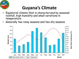
CLIMATE EQUATORIAL CLIMATE. VERY HOT AND RAINY THROUGHOUT THE YEAR. CONVECTIONAL RAINFALL The convectional rainfall is prevalent in equatorial regions. In these, the warm air rises up and expands then, reaches at a cooler layer and saturates, then condenses mainly in the form of cumulus or cumulonimbus clouds. In the equatorial regions, the precipitation due to convectional rainfall occurs in the afternoon Chapter 6/social/karunambigai/Sns Academy 7
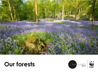
VEGETATION PLANT LIFE CANOPY A MASS OF LEAVES AND BRANCHES THAT SPREAD OVER AN AREA TO FORM A ROOF. EVERGREEN FOREST THE FOREST REMAIN GREEN THROUGHOUT THE YEAR. THE FOREST IS SO DENSE,IT IS DIFFICULT TO PASS THROUGH THEM. 8
WILDLIFE RICH IN WILDLIFE. GORILLAS,CHIMPANZEES,MONKEYS,BONOBOS AND BABOONS. HIPPOPOTAMUS.RHINOCEROS AND ELEPHANT. CROCODILES,ALLIGATORS AND FISH . OKAPIS AND ANTELOPES ARE FOUND IN ITURI FOREST. PELICANS,DUCKS.OWLS AND EAGLES. 9
ECONOMIC RESOURCES FARMING ,FORESTRY,FISHING AND LIVESTOCK REARING MAIN OCCUPATIONS. FOOD CROPS RICE,MAIZE AND CASSAVA. CASH CROPS COCOA,COFFEE,TOBACCO,COTTON,RUBBER AND OIL PALM. MINERALS GOLD,COBALT,COPPER,CADMIUM,PETROLEM,DIAMOND,SILVER,ZINC,MANGANESE,TIN,URA NIUM,IRON ORE,BAUXITE AND COAL. 10
LIFE OF THE PEOPLE THE COUNTRY IS THINLY POPULATED. CASSAVA ROOT STAPLE FOOD BANTU TRIBAL PEOPLE,THEY FOLLOW TRADITIONAL LIFESTYLES. PYGMIES INHABITANTS,THEY ARE ALSO KNOWNS AS BAMBUTI. THEY ARE VERY SHORT LESS THAN 150 CM TALL. THEY LIVE IN ITURI FOREST. THEY LEAD A PRIMITIVE LIFE. 11
TRANSPORT POOR LAND TRANSPORT. DENSE OF THE FOREST MADE DIFFICULT FOR BUILDING RAILWAYS AND ROADWAYS. THE COUNTRY HAS A NETWORK OF RIVERS. WATER TRANSPORT HAS BECOME THE CHIEF MEANS OF TRAVEL. AIR TRANSPORT IS VERY EFFECTIVE WAY TO TRAVEL. THE COUNTRY HAS MORE THAN 200 AIRPORTS. 12
CITIES 30 % OF THE TOTAL POPULATION LIVES IN TOWNS AND CITIES. KINSHASA IS THE CAPITAL AND LARGEST CITY. LUBUMBASHI IS THE MAIN CITY & MINERAL RICH REGION. BIG CITIES KANANGA,KISANGANI, LIKASI,KIKWIT. MATADI PORT CITY. 13
. 14