Earth's Geography: Location, Coordinates, and Hemispheres

Explore the concepts of absolute and relative locations, lines of latitude and longitude, GPS coordinates, and hemispheres in geography. Learn how to create a compass rose and label continents and oceans on a map. Understand how to describe locations using landmarks, direction, time, and distance.

Download Presentation

Please find below an Image/Link to download the presentation.
The content on the website is provided AS IS for your information and personal use only. It may not be sold, licensed, or shared on other websites without obtaining consent from the author.If you encounter any issues during the download, it is possible that the publisher has removed the file from their server.
You are allowed to download the files provided on this website for personal or commercial use, subject to the condition that they are used lawfully. All files are the property of their respective owners.
The content on the website is provided AS IS for your information and personal use only. It may not be sold, licensed, or shared on other websites without obtaining consent from the author.
E N D
Presentation Transcript
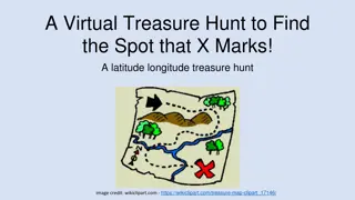
Location Annotated Map Activity
On Your Blank Map Label 7 continents 4 oceans Create a compass rose in the upper right hand corner of your paper.
Relative Location Described by landmarks, time, direction, or distance from one place to another. Examples: Ms. Rains class is down the 6thgrade hall on the left. AMS is about a mile from Kroger on Ridge Road. Arbor Place Mall is off I-20 in Douglasville.
Absolute Location Describes the location of a fixed point on the earth. Normally expressed using coordinates such as latitude and longitude. Examples: Eiffel Tower is 48.8584 N, 2.2945 E Arbor Place Mall is 33.7279 N, 84.7440 W The White House is 38.8977 N, 77.0365 W
Absolute Location Cont. Absolute Location is based off the Global Positioning System (GPS).
Hemispheres Half of the Earth. The Equator creates the Northern and Southern hemispheres. The Prime Meridian creates the Eastern and Western hemispheres.
Lines of LATITUDE (parallels) Imaginary lines on the Earth that run parallel to the equator.
Lines of LONGITUDE (meridians) Imaginary lines that run between North and South Poles
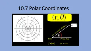
Finding GPS Latitude (North or South) always comes first. Longitude (East or West) always comes second. 0 degrees doesn t have direction but you should know that it s the equator or prime meridian. Examples: (35.9550 N , 83.9250 W)


")
")