
Midterm Review Mission: Data processing
The responsibilities, history, devices, apps, and techniques involved in data processing, covering tasks like developing apps, training, technical support, and integrating GIS. Learn about the evolution from paper-based data collection to handheld devices and modern applications. Discover how the Ge
2 views • 15 slides

Oklahoma Transportation GIS Cabinet Overview
Oklahoma's Transportation Cabinet consists of three agencies responsible for managing federal aid highways, county roadway data aggregation, Turnpike infrastructure, and aeronautics. The GIS infrastructure includes 18 full-time staff primarily using Esri Enterprise GIS tools for data integration and
1 views • 10 slides
Overview of Data Science: Uncovering Insights from Data
Data science is a multi-disciplinary field that utilizes scientific methods to extract knowledge from various types of data. Data scientists play a crucial role in uncovering valuable insights for organizations by mastering the full data science life cycle and possessing key skills such as curiosity
4 views • 46 slides

GIS Data Management in Hydrologic Engineering Center (HEC) Software
Efficiently manage GIS data in HEC software by organizing background shapefiles, saving files in relevant directories, and utilizing relative pathnames. Understand the contents of basin files, GIS directories, and the step-by-step process involved in the delineation of elements within a project.
9 views • 5 slides

Applications of GIS in Urban Planning and Spatial Operations
This presentation explores the wide range of applications of Geographic Information Systems (GIS) in urban planning, transportation management, utility management, environmental sciences, political science, civil engineering, business, education, real estate, healthcare, and more. GIS facilitates ta
1 views • 19 slides
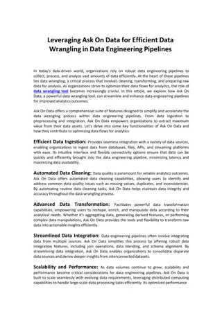
Ask On Data for Efficient Data Wrangling in Data Engineering
In today's data-driven world, organizations rely on robust data engineering pipelines to collect, process, and analyze vast amounts of data efficiently. At the heart of these pipelines lies data wrangling, a critical process that involves cleaning, transforming, and preparing raw data for analysis.
2 views • 2 slides

Introduction to Enterprise Databases for GIS Professionals
Explore the world of enterprise databases through a GIS perspective with a focus on concurrent clients, database administration, creating databases/tables, checking service names, unique features, numeric data types, data type parameters in ArcGIS, and character data types. Gain insights into managi
0 views • 52 slides
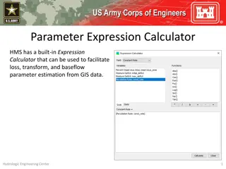
Parameter Expression Calculator for Efficient Parameter Estimation from GIS Data
Parameter Expression Calculator within HEC-HMS offers a convenient tool to estimate loss, transform, and baseflow parameters using GIS data. It includes various options such as Deficit and Constant Loss, Green and Ampt Transform, Mod Clark Transform, Clark Transform, S-Graph, and Linear Reservoir. U
1 views • 5 slides

Evolution of Data Processing Systems in Geographic Information Science
Data processing systems in Geographic Information Science have evolved from manual, analogue methods to advanced software and hardware components. The incorporation of Geographic Information Systems (GIS) has revolutionized the handling and analysis of geo-referenced data, making tasks like data cap
0 views • 20 slides

Understanding Geographic Objects in GIS
Geographic objects play a crucial role in GIS by being easily distinguished and named based on parameters like location, shape, size, and orientation. These objects are studied collectively to understand their interactions and relationships, aiding in tasks such as navigation systems and route optim
4 views • 13 slides

Geographic Information System in Sud Nouvelle Calédonie
The province of Sud Nouvelle Calédonie utilizes an open-source-based Geographic Information System (GIS) to serve its territorial administration, with a focus on applications such as land administration, environment, agriculture, and urban planning. The system is supported by a team of engineers, g
0 views • 15 slides
GIS Application for EPC Asset Damage Assessment post-2009 Tsunami
Utilizing Geographic Information Systems (GIS) for assessing damage to EPC assets after the 2009 Tsunami event. Explore worst-hit and affected areas, query assets, evaluate damage, and derive secondary results for the National Emergency Operations Center (NEOC).
0 views • 8 slides

Understanding Spatial Analysis in GIS for Effective Decision-Making
Spatial analysis in GIS involves modeling geographic problems, processing data, and exploring results to understand spatial relationships, patterns, and suitability for various purposes. GIS tools offer unique capabilities for handling geographically referenced data, data entry, storage, manipulatio
1 views • 21 slides
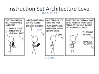
Understanding Instruction Set Architecture and Data Types in Computer Systems
In computer architecture, the Instruction Set Architecture (ISA) level is crucial in defining how a processor executes instructions. This includes the formal defining documents, memory models, registers, and various data types that can be supported. The ISA level specifies the capabilities of a proc
2 views • 13 slides

Foundations of Image Sensing and Acquisition in GIS
Understanding the process of image acquisition is crucial for digital image processing in GIS. It involves using physical devices sensitive to different energy bands to convert images into digital form through digitizers. Various methods such as single sensors, sensor strips, and sensor arrays are u
2 views • 16 slides

Understanding the Components of GIS for Spatial Planning
A geographic information system (GIS) is a powerful tool for capturing, storing, analyzing, and presenting spatial data. This training program explores the fundamentals of GIS, including software and hardware components, data considerations, and the importance of people and policies in utilizing GIS
4 views • 16 slides

Enhancing Fiji Police Operations with GIS Implementation
The Fiji Police Force is integrating Geographic Information Systems (GIS) to enhance policing operations through improved situational awareness, crime trend analysis, resource deployment, and cost savings. By investing in GIS technology, the force aims to optimize efficiency, decision-making, and ov
1 views • 17 slides

GIS Data Models for Spatial Planning Training in Maputo, Mozambique
Explore the concepts of GIS data models including vector vs. raster, spatial relationships, spatial operations, and representation of real-world entities in a spatial database. Understand how spatial data models are used to manipulate spatially-referenced information and define the spatial location
1 views • 32 slides

Pacific Climate Change Centre Seminar on GIS and FOSS4G
The Pacific Climate Change Centre in Apia organized a seminar focusing on the importance of GIS and FOSS4G technology. The event included discussions on open GIS data, user group meetings, and keynote speakers. Various local hubs from the Pacific region were involved in the event, showcasing the gro
0 views • 5 slides

Future Directions for GIS in Samoa
Enhancing GIS practices in Samoa involves establishing a Samoa GIS User Group, improving spatial data management, developing a national spatial data infrastructure framework, and implementing GIS applications in various sectors like emergency response, public access, and natural resource management.
1 views • 12 slides
Complete Guide to GIS Professional Certification Portfolio Application
Step-by-step guide on completing the GIS professional certification application process, including submission of a portfolio and passing the Geospatial Core Technical Knowledge Exam. Key components include education, experience, and contributions to the profession. Tips on documentation, requesting
3 views • 30 slides

GIS and Remote Sensing for Overlay Analysis Training Program
This training program focuses on GIS and remote sensing techniques for overlay analysis, covering topics such as data processing, suitability mapping, sensitivity analysis, and introduction to Python. The program includes practical sessions on QGIS, lithology, land use, recharge, TWI, and more. Part
2 views • 24 slides

Wetland Prediction Model Assessment in GIS Pilot Study for Kinston Bypass
Wetland Prediction Model Assessment was conducted in a GIS pilot study for the Kinston Bypass project in Lenoir County. The goal was to streamline project delivery through GIS resources. The study focused on Corridor 36, assessing various wetland types over a vast area using statistical and spatial
0 views • 16 slides

Colorado Broadband Data Collection Update and Infrastructure Enhancements
Updating the Colorado broadband data collection process with legislature funding for staff and GIS data coordination. Focus on nuanced data collection for various potential uses such as DOLA grants, broadband planning, and provider marketing. Statewide broadband mapping shows improved speeds for hou
1 views • 26 slides

Understanding Land Records and Surveying Practices
Explore topics such as re-locating section corners, working with corner data in GIS, and the importance of accurate survey control in managing GIS systems. Learn about the challenges surveyors face in maintaining section corners and the significance of finding original markers. Discover educational
0 views • 17 slides
GIS Emergency Handbook for DeWitt County Chemical Facilities
The GIS Emergency Handbook project addresses the risks posed by storing Extremely Hazardous Substances (EHS) in DeWitt County by providing vital information to first responders in an easily accessible format. The handbook includes details on chemicals, contacts, and facility information to aid in em
0 views • 18 slides
Oil Pollution GIS for the Wider Caribbean Region by RAC-REMPEITC
Utilizing GIS technology, RAC-REMPEITC focuses on preparedness and response to oil pollution in the Caribbean region. The initiative involves early warning systems, detection, decision-making, coordination, equipment location, remote sensing, modeling, and international support to protect the marine
0 views • 15 slides

Linking BIM and GIS Standard Ontologies with Linked Data
Introduction to the need for seamless data interpretation between Building Information Model (BIM) and Geographic Information System (GIS), focusing on aligning BIM and GIS standard ontologies for semantic interoperability. Addressing the challenges of data interoperability layers and the characteri
0 views • 15 slides

Understanding GIS Data Collection and Sources
Exploring various data sources for GIS projects, this information discusses the importance of data collection, different types of data (primary, secondary, administrative records), formats (digital, hardcopy), and the value of spatial data. Emphasizing the significance of in-house data and major GIS
0 views • 35 slides

GIS Data Preparation and Joining in ArcGIS
Learn the step-by-step process of preparing and joining data in ArcGIS for mapping projects. From eliminating unnecessary fields in Excel to loading and joining data in GIS, this guide provides detailed instructions to ensure accurate data representation. Exporting the finalized data allows users to
0 views • 9 slides
Geographic Information Systems: GIS in Statistics and INSPIRE Reporting Obligations
This document outlines the agenda and practical details for a GIS workshop focusing on statistical production and data processing related to geographic information systems. It includes sessions on population gridded data production, automation processes, and practical exercises. Participants from va
0 views • 5 slides

Bathymetry Trackline Fitting Techniques at ACM SIGSPATIAL GIS 2009
Tsz-Yam Lau, You Li, Zhongyi Xie, and W. Randolph Franklin presented various ship trackline fitting techniques at the ACM SIGSPATIAL GIS 2009 conference in Seattle. The study explored methods such as Inverse Distance Weighting, Kriging, Voronoi, Linear Spline, Quadratic Spline, and more for bathymet
0 views • 12 slides
Georeferencing in GIS: Understanding the Essential Concepts
Georeferencing is crucial in GIS for linking information to the Earth's surface. It involves assigning locations to data points using various measurements such as placenames, postal addresses, and coordinates. By understanding georeferencing systems, including metric references and linear referencin
0 views • 20 slides
Understanding Java Data Types and Variable Declaration
Dive into the world of Java data types and variable declaration with this comprehensive guide. Learn about primitive data types, declaring variables, integer types, floating-point data types, character data type, and boolean data type. Master the art of assigning names and data types to efficiently
0 views • 31 slides

Regional GIS User Group Meeting & Cooperative Purchase Agreement
Join the Regional GIS User Group Meeting on September 9th to discuss GIS initiatives and attend the Cooperative Purchase Agreement meeting thereafter to delve into project specifics. Learn about GIS training opportunities at ARC and stay updated on important announcements.
0 views • 6 slides
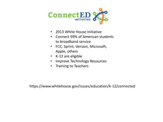
Transforming Education with Technology: Connecting American Students to Broadband and GIS Resources
In 2013, the White House initiated a program to connect 99% of American students to broadband service, supported by companies like FCC, Sprint, Verizon, Microsoft, Apple, and others. Additionally, Esri is offering $1 billion worth of ArcGIS access for K-12 schools, enhancing students' mapping and da
0 views • 4 slides
Understanding Coordinate Systems, Map Projections, and GIS Applications
Explore the intricacies of Geographic Coordinate Systems, Projected Coordinate Systems, and different types of map projections as part of the Remote Sensing and GIS Application course taught by Lecturer Ruba Yousif Hussain in the third year. Dive into the properties of map projections like conforman
0 views • 13 slides
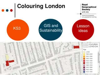
GIS and Sustainability Lesson Ideas for KS3 on Colouring London
Explore how Colouring London aims to make the city more sustainable by collecting information on every building. Engage students in discussions about sustainability, data collection, and use of GIS for mapping sustainability. Encourage hands-on fieldwork and online research to gather primary and sec
0 views • 24 slides
Stormwater Asset Management System (SAMS) Proof of Concept Overview
This project focuses on developing a Statewide Stormwater Asset Database and a GIS-based Stormwater Asset Management System (SAMS) for efficient inspection and reporting. It involves creating methodologies for database development, utilizing existing district data, implementing inspection protocols,
0 views • 27 slides

Interactive Data Visualization Tools and Techniques Quiz
This quiz tests knowledge on data visualization tools, techniques, and concepts. Questions cover topics such as the use of EDA in data visualization, interactive graph outputs, historical figures in data visualization, GIS data types in SAS/JMP, outlier detection in 3D scatterplots, and limitations
0 views • 11 slides